Whether you are looking to hike to arethusa falls, ripley falls, or both, this post will help you with all of the information you need.These stunning waterfall hikes are located only a couple miles apart, making it possible for hikers to do them separately, or combine them into a loop. Here, we will cover all of the hiking options.
Arethusa Falls: 2.6 miles (4.1km) Round Trip | 1,000 Feet (304.8 m) Elevation Gain
Ripley Falls: 1.2 mile (1.93 km) Round Trip | 348 Feet (106.07 m) Elevation Gain
Arethusa & Ripley Falls Loop: 6.5 miles (10.46 km) round trip
Quick Navigation:
Arethusa Falls | Ripley Falls | Hiking Both | Pictures | Directions
Hiking To Ripley Falls | 1.2 mile (1.93 km) Round Trip | 348 Feet (106.07 m) Elevation Gain
Ripley falls is a 100 foot waterfall in Hart’s Location of Crawford Notch New Hampshire. Gorgeous in all seasons, the short hike can be completed by individuals of all fitness levels.
Ripley Falls Trail
 This trail is 1.2 miles out and back (.6 each way) from the parking lot of 302 in Crawford Notch (directions below). It doesn’t gain too much elevation, so the hike to Ripley Falls can be done by almost anyone who is willing to work a little bit for an awesome waterfall. This is a well traveled trail.
How long does it take to hike to Ripley Falls?
Hiking to Ripley Falls is only a 10-20 minute hike to the falls, for a roundtrip total of 20-40 minutes for the average hiker. (The 100 foot waterfall is spectacular)
Trail Map
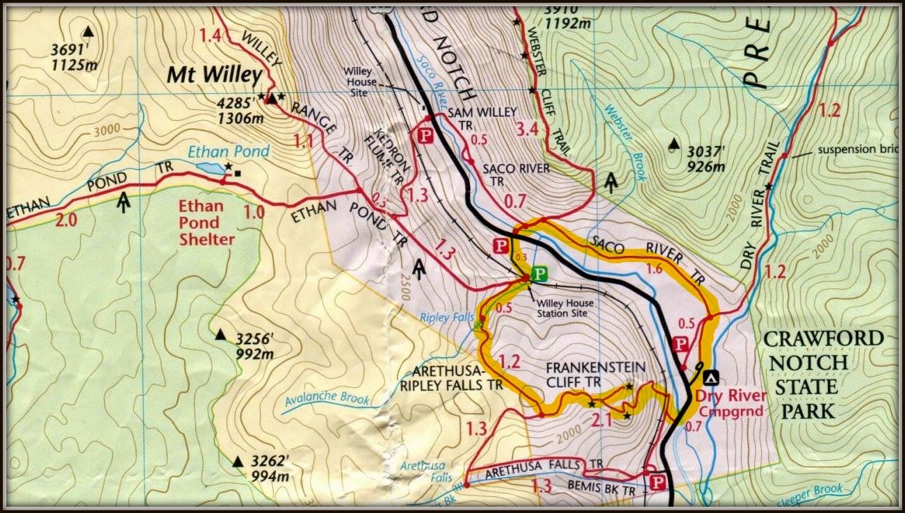
This map includes both Arethusa and Ripley Falls.
Hiking To Arethusa Falls | 2.6 miles (4.1km) Round Trip | 1,000 Feet (304.8 m) Elevation Gain
This is a 140 foot waterfall, from the Bemis Brook in Crawford Notch State Park. It is the second largest waterfall in the state, making it a must see for waterfall lovers. It can flow heavy during certain periods, but can also have low flow in certain months. In the winter, the falls freeze over, making for an incredibly beautiful ice wall.
Arethusa Falls Trail
This Trail is a 2.6 mile out and back trail (1.3 each way) from 302 in Crawford Notch. It is a relatively gradual elevation gain all the way to the falls. This is a well traveled trail.
How long does it take to hike to Arethusa Falls?
This should take 25-35 minutes each way for the average hiker.
Trails to the Arethusa
Hikers can choose to take the Bemis Brook Trail, or the Arethusa Falls Trail. Both are almost equal in length and difficulty. The Bemis Brook trail stays closer to Bemis Brook for a short period of time, so if you like rivers, definitely check out this path.
Combining Both Falls: Arethusa-Ripley Falls Trail
The hike from Ripley Falls to Arethusa Falls via the Arethusa-Ripley Falls Trail is not only gorgeous, but is relatively easy. It is doable for all experience levels, and there is plenty of parking right off of route 302 in Crawford Notch. Hiking just Ripley Falls is the easiest route. Arethusa is a little longer distance, but if you want your moneys worth, we recommend doing them both.
There is a 1.2 mile trail between Arethusa and Ripley Falls. It can be accessed right from Ripley Falls and only about .1 miles from Arethusa Falls. This trail is far less traveled than Ripley Falls Trail or Arethusa Falls Trail. It features a relatively thin path most of the way with a few quick elevation gain and loss sections between the two falls. This trail can be pretty muddy during wet times.
The entire loop will turn out to be 6.5 miles and will involve walking along 302 to get back to your car, taking the railroad tracks back to the other trailhead (my personal favorite) or you can trace your steps back the same way you came.
Elevation
Arethusa falls is at around 2,150 feet, and the trailhead is at an elevation of 1,350 feet. This results in an elevation gain of around 800 feet.
Ripley falls is at around 1,800 feet and the trailhead is at an elevation of 1,450 feet. This results in an elevation gain of around 350 feet.
You may also like some of the best short hikes in NH: Mount Willard and Mount Crawford
Directions and Parking
Both parking lots are conveniently located off of 302 in Crawford Notch. The lots can get busy, but you can always find a spot on the side of the road if necessary.
Directions
Arethusa Falls Trailhead Address:
The Trailhead is located off of 302 (Crawford Notch Road). The parking area is marked clearly by a large sign.
Ripley Falls Trailhead:
The trailhead is located off of 302 only a couple of miles away from the AMC Highland Center.
Great swimming holes on the Saco are nearby as well as tons of waterfalls, some 4,000 foot hikes and even incredibly gorgeous short day hikes like Mount Willard. Frankenstein Cliff is another short hike option which can be combined with either waterfall, or hiked as a separate trip.
Trail Map
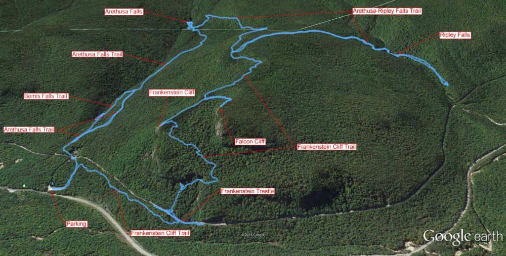
Image Source: Hopsonrocks.com
Source: http://hopsonrocks.com/hikes/2015/arethusa.html
Weather Forecast
Bartlett, NH
Overnight
Scattered rain showers. Mostly cloudy, with a low around 36. Southeast wind around 0 mph.
Friday
Mostly cloudy, with a high near 51. Southeast wind 5 to 10 mph.
Friday Night
A chance of rain showers between midnight and 2am, then a chance of rain. Cloudy, with a low around 38. South wind 5 to 15 mph, with gusts as high as 25 mph. Chance of precipitation is 50%. New rainfall amounts less than a tenth of an inch possible.
Saturday
A chance of rain before 10am, then a chance of rain showers. Mostly cloudy, with a high near 51. Northwest wind 5 to 15 mph, with gusts as high as 30 mph. Chance of precipitation is 40%.
Saturday Night
A chance of rain showers before 7pm. Partly cloudy, with a low around 32. West wind 10 to 15 mph, with gusts as high as 30 mph. Chance of precipitation is 30%.
Sunday
Mostly sunny, with a high near 48.
Sunday Night
Mostly clear, with a low around 30.
Pictures of Ripley Falls and Arethusa Falls:
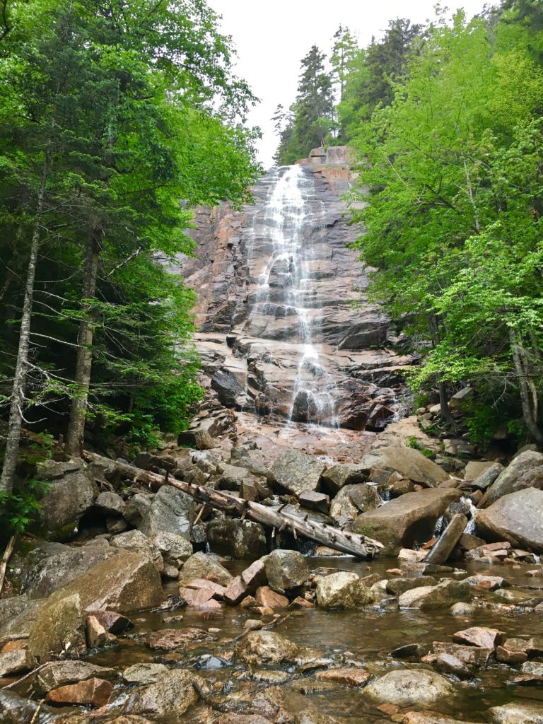
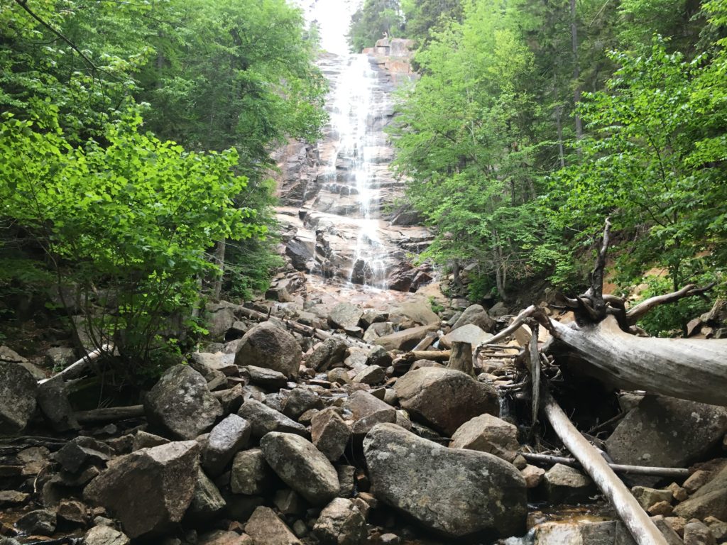
Picture from Base of Arethusa Falls
Arethusa is a 300 foot gorgeous waterfall on Bemis Brook. Bemis Brook eventually flows into the Saco River.
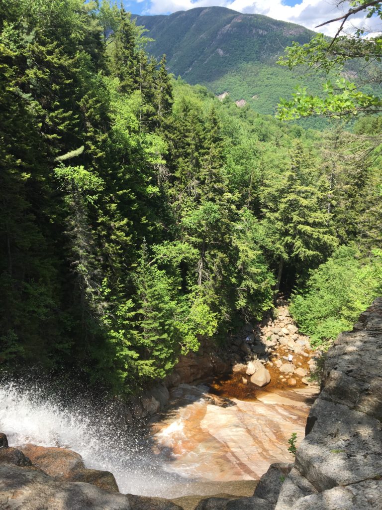
From the Top of Ripley Falls
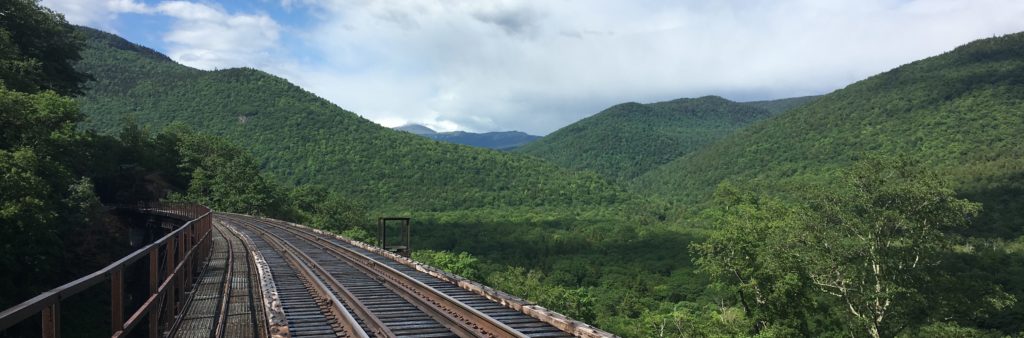
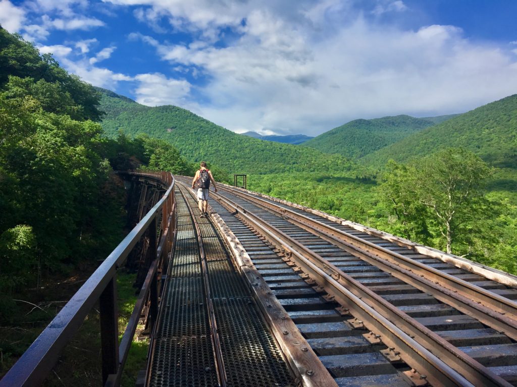
Railroad Connecting Arethusa and Ripley Falls Trailhead
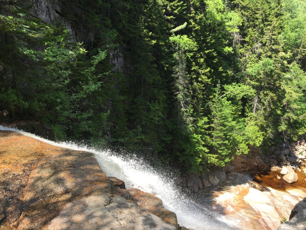
Top of Ripley Falls

Max DesMarais is the founder of hikingandfishing.com. He has a passion for the outdoors and making outdoor education and adventure more accessible. Max is a published author for various outdoor adventure, travel, and marketing websites. He is an experienced hiker, backpacker, fly fisherman, backcountry skier, trail runner, and spends his free time in the outdoors. These adventures allow him to test gear, learn new skills, and experience new places so that he can educate others. Max grew up hiking all around New Hampshire and New England. He became obsessed with the New Hampshire mountains, and the NH 48, where he guided hikes and trail runs in the White Mountains. Since moving out west, Max has continued climbed all of the Colorado 14ers, is always testing gear, learning skills, gaining experience, and building his endurance for outdoor sports. You can read more about his experience here: hikingandfishing/about
Very Rainy - but waterfall huge!
We had to pivot our plans because of the rain in the forecast. We pivoted to see waterfalls hoping they would have some extra water. Didn’t disappoint!!