If you’re a hiker, backpacker, or really anyone that spends time in the backcountry, you need more safety equipment for navigation. Handheld GPS devices are used for navigation purposes, sending emergency requests to rescue services, as well as communicating with friends, family, and rescue services. These devices come with different features, from simple personal locator beacons (just SOS devices), to full blown handheld mapping and texting devices, and hybrid devices in between. In this article, we are going to highlight our choices for the best GPS devices for hiking, as well as some devices we may recommend against and why.
What Is GPS?
GPS (Global Positioning System) is a satellite-based navigation system that allows users to determine their precise location and track their movements anywhere on Earth. A GPS unit for hiking is a handheld device that uses GPS technology to help you navigate while exploring the outdoors. These devices are typically rugged and durable, with features designed specifically for outdoor use, such as water resistance, durable casings, and long battery life.
Types Of Handheld GPS Devices
We wanted to break down the types of GPS devices you’ll come across, the pros and cons of each to help you identify which is best for your needs.
Personal Locator Beacons
Personal locator beacons are one way communication devices that simply allow for the communication of an SOS signal, and the sending of a location repeatedly. This is the simplest type of device.
Pros:
- Personal locator beacons usually do not require
- Ultra durable, waterproof, and great battery life
- Small in size and lightweight
- Usually do not need any paid subscription plan to be functional
Cons:
- No two-way communication
Handheld GPS Navigators
Handheld GPS navigators have the ability to two way message, the ability to display a map on the screen, and the ability to send an SOS emergency signal with location information. These are the ultimate tools as they are great for navigation, communication, and emergency situations.
Pros:
- Two way messaging without the need of a phone
- Mapping on devices
- Easy emergency communication
Cons:
- Need a subscription to operate
- Generally more bulky and heavier.
Hybrid Devices
Hybrid devices are devices that function primarily as personal locator beacons, but they can connect with your phone via bluetooth for two way messaging via satellite connection. These devices usually don’t have a screen.
Pros:
- Often very small and lightweight
- Allow for two way messaging with your phone
Cons:
- Requires a subscription to operate
- No mapping functionality
- Two way messaging is only possible while connected via Bluetooth to your phone.
Key Features of GPS Units
There are several features to consider when choosing a GPS for hiking. These include, but are not limited to the following:
- Satellite connectivity: The device needs to have a strong connection to a GPS satellite network to accurately determine the user’s location. Many devices can connect to several satellite systems around the globe.
- Maps: Many handheld GPS devices come with preloaded topographic maps or allow users to upload their own maps to help them navigate in the wilderness.
- Waypoint creation: Waypoints are specific locations that hikers may want to visit or navigate to. Handheld GPS devices allow users to create and store waypoints for future reference.
- Tracking: GPS devices can track the user’s movements and create a trail, which can be saved for future reference or shared with others.
- Battery life: Handheld GPS devices typically use AA or rechargeable batteries, and battery life can vary widely depending on the device and usage.
- Satellite two-way messaging: Satellite messengers differ from personal locator beacons as they allow for two way messaging with rescue authorities or with family and friends via GPS as well. All of the devices we list here allow for two way messaging on your device, and many also connect to your phone via bluetooth for even easier messaging. We avoided devices on this list that didn’t allow for two way messaging without the need for your phone.
Additionally, many GPS units feature ABC. This stands for “altimeter, barometer, compass.”
- Altimeter: Measures the user’s altitude above sea level, which can be useful for navigating in mountainous terrain.
- Barometer: Measures atmospheric pressure and can help indicate when weather changes are on their way.
- Compass: Helps you orient yourself and navigate in areas where GPS signals are weak.
Another feature of many modern GPS units is satellite messaging. These devices can transmit rescue messages or SOS alerts via satellite, and may even have text messaging capabilities for communication with loved ones. GPS units with this capability will allow you to connect in areas without cell service.
Sometimes this is done directly on the device; smaller devices will connect to your phone with Bluetooth and allow you to connect from there. Choosing a unit with this connectivity feature means that you won’t need to carry a separate satellite messenger, which can be great if you want to cut down on the amount of items you carry.
GPS Subscriptions
Nearly all GPS devices with messaging require a subscription to use. You do not need a subscription to access the GPS satellites; those are owned by the US government, not a private network. However, certain maps and satellite communication features do require a subscription. If your GPS has any kind of two-way satellite communication, it will require a subscription. You may also need to subscribe to map updates.
Using Your Phone As A GPS
While GPS units have been a standard part of safe hiking for the past two decades or so, many hikers have found that they prefer using their phone as a GPS. Apps like OnX or FatMaps can provide you with excellent navigation tools. These apps are great for trip planning and understand what your route will look like ahead of time. You can even download maps ahead of time if you want to use them in the field and not worry about reception. There are several reasons why people like using their phones as a GPS, including:
- Phones are convenient– you likely already carry your phone everywhere with you.
- Phone GPS apps update frequently.
- Most phones already have integrated GPS apps, and there are lots of standalone apps available.
- Phones don’t need cell service to access GPS data.
But there are numerous drawbacks to using your phone as a GPS:
- Phones are less durable and typically less water-resistant than a dedicated GPS unit. If your phone is your only GPS unit and it breaks or gets wet, you could have a serious problem.
- Phone battery life is not as long as a GPS unit’s battery life. You can get around this to an extent with an external battery pack, but GPS units can have battery life in the hundreds of hours.
- Phones still do not have two way communication capabilities through satellites. Messaging features are extremely important in emergencies.
Ultimately, it’s up to you whether or not you want a dedicated GPS unit. But if you’re on unknown terrain, challenging terrain, or planning a hike that’s more than just a few hours, a GPS unit is likely going to be more useful than just your phone.
Using A Smartwatch As GPS
Another GPS option that is becoming increasingly popular is the smartwatch. Garmin makes a number of GPS watch models, with the Fenix 7 held in particularly high regard as a great watch to take into the backcountry. Even the newer Apple watch models can be used as a GPS! In addition to how convenient these watches are, there are other reasons that people enjoy using a watch as a GPS:
- You wear your watch, so it’s always at hand and doesn’t add to the carry weight in your pack. This makes these watches particularly good for trail runners and ultralight hikers.
- GPS watches offer real-time location updates, making it easy to navigate.
- Smartwatches have features like step counting, weather updates, and heart rate monitoring, which can help you make decisions about when to take breaks, make camp, and more.
However, there are some drawbacks to using your watch as your sole GPS unit.
- Battery life can be an issue; using GPS drains these watches’ batteries, which means that you’ll need to have a charging cord and power bank if you’re going out for more than a day hike (with many watches).
- Watch screens are small, so it can be hard to see the map or read directions. Additionally they aren’t always very bright, which can make them hard to read in the sun.
- Smartwatch storage is limited, so you might not be able to have access to all the maps you want.
- Some watches don’t have map capabilities, so they only function as trackers, or can tell you direction, not give you a position on a map.
The Best GPS Units for Hiking
When choosing a GPS for hiking, there are many factors to consider, such as battery life, durability, features, and ease of use. By understanding the key features of GPS devices, you can make an informed decision and choose the one that will enhance your hiking experience and work with your hiking needs.
When you’re looking for a GPS to take hiking, you will see one name come up over and over: Garmin. Garmin has dominated the GPS market for years, and for good reason. Garmin has been the market leader for GPS essentially since the technology was developed. Founded in 1989 and adopted by the US military in 1991, Garmin’s equipment is known for being durable, reliable, and accurate. There’s a reason that Garmin dominates the list of the best GPS for hiking!
Garmin inReach Mini 2
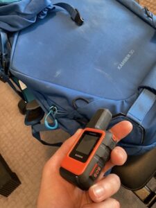
Garmin InReach Mini on our backpack
The Garmin inReach Mini2 is an incredibly useful device. It’s a fully capable satellite communicator with GPS features, making it the perfect safety companion for your hiking and camping adventures. It has a built-in compass, TracBack routing for wayfinding, ability to upload routes and waypoints, and connects to your phone for easy satellite messaging (including two-way and group messaging) and map viewing. Most importantly, it allows for messaging directly on the device in case of emergency, while also being extremely small and lightweight. In our opinion, this makes it one of the best devices on the market as it covers all of the needs while maintaining a small profile.
- Pros: Reliable, wide-ranging connectivity, easy read LCD screen, long battery life, extremely small and lightweight
- Cons: Requires a smartphone connection and app for topo map access and most communication features, small screen
Garmin inReach Mini2 Infobox
| Satellite Communication/SOS | Yes |
| Battery Life | 14 days in 10-minute tracking mode |
| Water Resistance | Yes, IPX7 |
| Screen Size | 2.5 inch diagonal |
| Touchscreen | No |
| Weight | 3.5 ounces |
| Cost to Buy | $400 |
| Cost for GPS Subscription | $14.95 monthly for the Consumer: Safety Plan |
Garmin inReach Explorer+
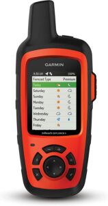 The inReach Explorer+ is far more than just a GPS– it’s an incredibly reliable satellite communicator that allows you to stay in touch via satellite messaging. It also has fully featured GPS functionality, weather forecasting, and an SOS button.
- Pros: Impressively reliable connectivity, ABC sensors, easy to use tracking features
- Cons: Requires a smartphone app for easy messaging
Garmin inReach Explorer+ Infobox
| Satellite Communication/SOS | Yes |
| Battery Life | 100 hours, or 30 days in power saving mode |
| Water Resistance | Yes, IPX7 |
| Screen Size | 2.3 inches |
| Touchscreen | No |
| Weight | 8 ounces |
| Cost to Buy | $449 |
| Cost for GPS Subscription | $14.95 monthly for the Consumer: Safety Plan |
Buy on Amazon | Buy at Garmin | Buy at Walmart
Spot X
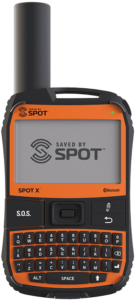
The Spot X is a device designed for easy messaging. It has a full keyboard with backlit keys, an easy to use interface, easy SOS button, and still maintains a relatively small profile and size. This is a great all around too.
Spot X Infobox
| Satellite Communication/SOS | Yes |
| Battery Life | 240 hours |
| Water Resistance | Yes, IPX7 |
| Screen Size | 2.9 inches |
| Touchscreen | No |
| Weight | 7 ounces |
| Cost to Buy | $249.95 |
| Cost for GPS Subscription | Starting at $11.95 per month |
Buy On Amazon | Buy On Spot | Buy On REI
Garmin eTrex 32x
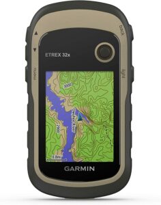
Garmin eTrex 32x
Garmin’s eTrex model is a great affordable GPS unit with lots of features that you’d expect in a more expensive unit. It comes preloaded with topo maps and is very durable and water resistant. It is also very small and lightweight, making it perfect for ultralight backpackers.
- Pros: Lightweight, affordable, ABC sensors at a very low price point
- Cons: Joystick and user interface take some getting used to, slower connectivity than other Garmin models, no SOS or satellite communication capabilities
Garmin eTrex 32x Infobox
| Satellite Communication/SOS | No |
| Battery Life | 25 hours in GPS mode |
| Water Resistance | Yes, IPX7 |
| Screen Size | 2.2” |
| Touchscreen | No |
| Weight | 4.96 ounces |
| Cost to Buy | $299.99 |
| Cost for GPS Subscription | $14.95 monthly for the Consumer: Safety Plan |
Buy on Amazon | Buy at Garmin | Buy on REI
Garmin Montana 700
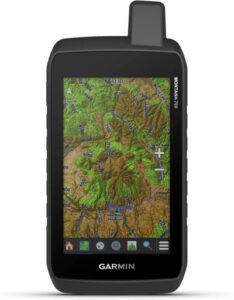 The Garmin Montana 700 (and closely related 700i and 750 models) is a virtually indestructible system that comes with 16 gbs of internal storage preloaded with US Federal Public Lands layers stacked on Garmin’s TopoActive regional maps. Buying this GPS includes an unlimited subscription to Garmin’s BirdsEye Satellite Imagery; when combined with Garmin’s Maps+ GPS subscription, there’s nowhere the Montana 700 series can’t show you. We do want to note that this is a larger device, making it recommended when mapping is essential on the device you are looking for, and not ideal if you are looking to slip down your gear.
- Pros: Versatile, fast, easy to use, touch screen is glove compatible, ABC sensors
- Cons: Heavy and large, almost too big to comfortably be a handheld system
Garmin Montana 700 Infobox
| Satellite Communication/SOS | Yes; the 700i has two-way satellite communication |
| Battery Life | 18 hours GPS mode, 330 in expedition mode |
| Water Resistance | Yes, IPX7 |
| Screen Size | 5 inches |
| Touchscreen | Yes |
| Weight | 23 ounces |
| Cost to Buy | $599.99 |
| Cost for GPS Subscription | $14.95 monthly for the Consumer: Safety Plan |
Garmin Oregon 750T
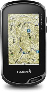 The most user-friendly of Garmin’s many offerings, the Oregon 750T is a very handy device that’s loaded with features. It comes with a built-in camera that geotags your pictures, expanded wifi capabilities, and a dual battery system that lets you use standard batteries or a rechargeable power pack. It is a lightweight, compact model that will fit perfectly into your hiking kit. It’s especially good for backcountry skiing, since the touchscreen is easy to use with gloves.
- Pros: Dual orientation touch screen (like most smartphones), easy to see in sunny conditions, adjustable touch sensitivity for gloves, ABC sensors
- Cons: Shorter battery life, touch screen is a con for certain situations as well.
Garmin Oregon 750T Infobox
| Satellite Communication/SOS | No |
| Battery Life | 16 hours |
| Water Resistance | Yes, IPX7 |
| Screen Size | 3” |
| Touchscreen | Yes |
| Weight | 7 ounces |
| Cost to Buy | $549.99 |
| Cost for GPS Subscription | $14.95 monthly for the Consumer: Safety Plan |
Garmin GPSMAP 66ST
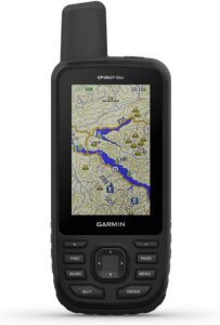
The Garmin GPSMAP 66ST is an award-winning device beloved by hikers for its speed, great connectivity, and free preloaded topo maps. This device’s powerful antenna can transmit even under thick tree cover, and when you’re in an area with cell service, it can connect to your phone for instant overlays of local weather data. If you want two-way satellite communication, you can upgrade to the 66I, which gives you access to the Garmin inReach technology. It comes with 32 gigs of internal memory, so you can load as many maps and waypoints as you could ever want.
- Pros: Fast, powerful, rugged, extremely strong connectivity
- Cons: Menus are complicated, device is a little bulky
Garmin GPSMAP 66ST Infobox
| Satellite Communication/SOS | No |
| Battery Life | 16 hours; 170 hours in expedition mode |
| Water Resistance | Yes, IPX7 |
| Screen Size | 3” |
| Touchscreen | No |
| Weight | 8.1 ounces |
| Cost to Buy | $450 |
| Cost for GPS Subscription | $14.95 monthly for the Consumer: Safety Plan |
Magellan eXplorist 310
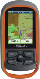 The Magellan eXplorist 310 is an easy to use entry-level GPS. While it is a pretty basic model (which the price tag reflects), it is durable and sturdy, with a screen that is easy to see in sunlight. The buttons are a little small, but the user interface and menu system are very easy to use, which helps make up for any shortcomings in the design. This unit is particularly loved by geocachers and comes with several features preinstalled for paperless geocaching.
Pros: Inexpensive, good screen
Cons: Slower map drawing speed, cramped button interface
Magellan eXplorist 310 Infobox
| Satellite Communication/SOS | No |
| Battery Life | 18 hours |
| Water Resistance | Yes, IPX7 |
| Screen Size | 2.2” |
| Touchscreen | No |
| Weight | 5.2 ounces |
| Cost to Buy | $199.99 |
| Cost for GPS Subscription | N/A |
Best GPS For Hiking Comparison Chart
Want to see how the GPS units compare head to head in key features? Here’s a handy comparison chart to see how their features stack up against each other.
| System | Price | Two-Way Satellite Communication | Battery Life | Extra Features |
| Garmin Montana 700 | $599.99 | Yes (700i model) | 18 hours | Huge internal storage, ABC sensors |
| Garmin InReach Mini 2 | $400.00 | Yes | 14 days | Very small, very lightweight, great battery life |
| Spot X | $249.99 | Yes | 10 days | Full keyboard for easy messaging |
| Garmin inReach Explorer+ | $449 | Yes | 100 hours | ABC sensors, automatic battery saving features for huge battery life |
| Garmin eTrex 32x | $299.99 | No | 25 hours | ABC sensors, extremely lightweight (about 5 ounces) |
| Garmin Oregon 750T | $549.99 | No | 16 Hours | ABC sensors, lightweight, glove-friendly touchscreen |
| Garmin GPSMAP 66ST | $450 | Yes (66i model) | 16 hours | ABC sensors, huge internal memory |
| Magellan eXplorist 310 | $199.99 | No | 18 hours | Inexpensive, durable |
Best Hybrid GPS Devices
ZOLEO Satellite Communicator: See On BlueCosmo | See On Amazon | See On REI
ACR Bivy Stick: See On ACR | See On Amazon
SPOT Gen 4: See On Spot | See On Amazon | See On REI
All three of these devices are personal locator beacon devices that allow for two way messaging. These are awesome devices, but they have a few drawbacks:
- In order to message, you must have access to your phone as the device connects to your phone via bluetooth in order to send messages.
- If your phone is broken or does not have battery, the device is only a personal locator beacon, and therefore it can only send an SOS.
- These devices still require subscriptions to utilize that are comparable to Garmin’s pricing. the SPOT series cheapest plan is cheaper than Garmin by a few dollars a month.
That being said, these devices are pretty awesome for a few reason:
- They are small and lightweight.
- As long as your phone is not broken, and has battery, it can connect to these devices for two way messaging.
We believe if you are going to invest in a device, that you should elect in one that can have two way messaging without your phone. Doing so often means you need a larger device size, but the Garmin Inreach Mini 2 as a device in the middle where it is ultra small, but still allows for two way messaging without your phone (but easier messaging is still possible on your phone). That being said, these hybrid devices give fantastic functionality, and an added layer of safety that is a fantastic option for hikers and backpackers.
A good GPS can make your outdoor adventures safer and more fun. We hope that your questions about GPS features have been answered and that our list makes your next GPS purchase easier!

Max DesMarais is the founder of hikingandfishing.com. He has a passion for the outdoors and making outdoor education and adventure more accessible. Max is a published author for various outdoor adventure, travel, and marketing websites. He is an experienced hiker, backpacker, fly fisherman, backcountry skier, trail runner, and spends his free time in the outdoors. These adventures allow him to test gear, learn new skills, and experience new places so that he can educate others. Max grew up hiking all around New Hampshire and New England. He became obsessed with the New Hampshire mountains, and the NH 48, where he guided hikes and trail runs in the White Mountains. Since moving out west, Max has continued climbed all of the Colorado 14ers, is always testing gear, learning skills, gaining experience, and building his endurance for outdoor sports. You can read more about his experience here: hikingandfishing/about