
Rocky Mountain National Park is one of the most beautiful places in the United States. Millions of visitors come each year to see incredible mountain scenery, waterfalls, elk, frozen lakes, go rock climbing, or to simply drive over one of the most stunning roads in the country. Living in Colorado has enabled our team to test out a larger portion of the hikes in the park. Here is our list of top hikes organized by difficulty. For each hike, we also have a link to our article with all the info you need to head out on the trails for that spot.
Quick Navigation:
Best Easy Hikes | Best Intermediate Hikes | Best Difficult Hikes
Need To Know Information
- During a large portion of the year, Rocky Mountain National Park requires permits. Permits can be purchased here along with all other relevant info: https://www.recreation.gov/timed-entry/10086910
- Other permit info (You should read this information): https://www.nps.gov/romo/planyourvisit/timed-entry-permit-system.htm
- Dogs are not allowed in Rocky Mountain National Park
- Parking fills up, so the shuttle system in the park can be used when it does.
- Some of these hikes don’t require a national park pass due to where they are located (info for each hike below).
Best Easy Hikes In Rocky Mountain National Park
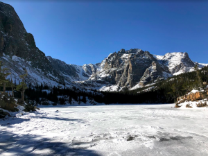
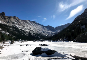
Dream Lake – Elevation: 9,905 Feet (3,019 M)
Dream Lake is simply stunning. It features incredible views of Hallett Peak, stunning trees, wildlife can often be found, and even great fishing. The trail features a gradual gain and only gets relatively steep in the last portion of the hike. This is a must do hike for anyone heading to Rocky Mountain National Park.
You’ll find many that park at this parking area and walk around Bear Lake as well. This is even simpler, but still had great views. For information on Bear Lake, see here:
Dream lake is often combined with Emerald Lake, which is on our list below in the intermediate level hikes.
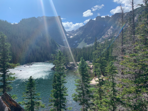
Views overlooking Dream Lake during summer.
Trail: Dream Lake Trail from Bear Lake Trailhead
Difficulty: Easy
Distance: 2.2 Miles (3.54 km) Round Trip
Elevation Gain: 450 feet (137.2 m)
Duration: 1-2 hours
More Hiking Information: Hiking Dream Lake
Bierstadt Lake – Elevation: 9,466 Feet (2,885 M)
Bierstadt Lake is less traveled compared to some of the other lakes in the area, but still highly trafficked. It features a simple but relatively steep trail that rises quickly to the lake where you get outstanding views of the surrounding peaks and the lake. While this lake alone is gorgeous, the same trailhead can be used in winter for access to lots of great cross country skiing.
 Trail: Bierstadt Lake Trail
Difficulty: Easy
Distance: 2.4 Miles (3.86 km) Round trip
Elevation Gain: 675 feet (205.7 m)
Duration: 2-3 hours
More Hiking Information: Hiking Bierstadt Lake
Ouzel Falls – Elevation – 9,400 Feet (2887.07 Meters)
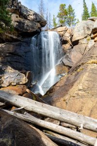 Ouzel Falls is located on the southeastern end of Rocky Mountain National Park and features well maintained trails along the gorgeous North Saint Vrain Creek. Ouzel Falls themselves are beautiful, but hikers get several other waterfalls on the way to the larger Ouzel Falls. With great fishing along the route, and access to other waterfalls and lake hikes on the way to the falls, this is a fantastic easy to intermediate hike option.
Distance: 5.32 miles round trip (8.56 km)
Height: 9,472 feet (2887.07 m)
Elevation gain: 1,216 feet (370.64 meters)
Duration: 4-5 hours
Difficulty: Easy/Intermediate
More Hiking Information: Hiking Ouzel Falls
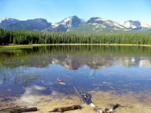
Bear Lake Loop Colorado 9,475 Feet (2878 Meters)
 Bear Lake is only about 100 feet from the parking lot, making it accessible to almost everyone. Hikers can choose to look at the first viewpoint, or walk a flat loop around the entire lake. The Rocky Mountain Conservancy even sells booklets at the trailhead teaching visitors on the natural history of Bear Lake as they walk around the signed educational postings around the lake.
Elevation: 9,475 Feet (2878 m)
Distance: .8 Miles (1.29 km)
Elevation Gain: 45 feet (13.7 m)
Difficulty: Easy
Duration: 1 hour or less
More Hiking Information: Hiking Bear Lake Loop
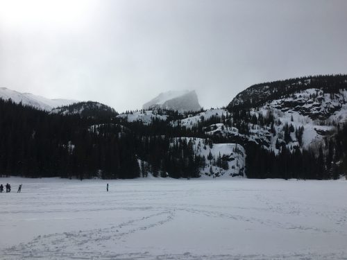
Alberta Falls – Elevation: 9,400 Feet (2865 Meters)
Alberta Falls is on the way to Mills Lake, Loch Vale, and many other gorgeous lakes. We therefore had to put this on the list as one of the best easy hikes. You’ll reach the falls in less than a mile, and likely should continue on to some of our intermediate and difficult hikes if you are feeling up for the challenge.
Read our guide to Mills Lake, Loch Vale, or others to get the information to hike to Alberta Falls.
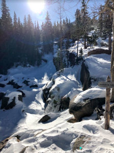
Alberta Falls (Winter) – It looks WAY more beautiful in summer.
Trail: Glacier Gorge Trailhead
Difficulty: Easy
Distance: 1.7 Miles (2.74 km) Round trip
Elevation Gain: 200 feet (60.96 m)
Duration: 1-2 hours
More Hiking Information: Hiking Alberta Falls
Best Intermediate Level Hikes In Rocky Mountain National Park
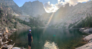
The Loch (Loch Vale) – Elevation: 10,190 Feet (3,105.9 M)
This hike is another one of those absolute must hikes in Rocky Mountain National Park. Getting to Loch Vale is beautiful because you pass right on by Alberta Falls, quickly get to insanely beautiful views for an amazing lunch spot, and then are right at the junction of many of the other top hikes in Rocky Mountain National Park (many on this list). So, if you are feeling really great when you reach Loch Vale, you can choose to continue on to some other awesome lakes or peaks.
Views from The Loch (Loch Vale)
Trail: Glacier Gorge Trailhead or Bear Lake Trailhead
Difficulty: Intermediate
Distance: 5.7 miles miles round trip (9.17 km)
Elevation Gain: 1,040 feet (316.99 meters)
Duration: 3-5 hours
More Hiking Information: Hiking Loch Vale
Emerald Lake – Elevation: 10,110 Feet (3,081.5 M)
As stunningly gorgeous as Dream Lake is, we highly recommend walking just a touch further and visiting Emerald Lake. The views get even more stunning as hikers sit just below massive cliffs, with an incredibly blue lake just in front. This is absolutely worth the extra effort.
This trail is also located at the end of Bear Lake Road.
 Trail: Dream Lake Trail To Emerald Lake Trail from Bear Lake Trailhead
Difficulty: Intermediate
Distance: 3.5 Miles (3.54 km) Round trip
Elevation Gain: 650 feet (198 m)
Duration: 2-3 hours
More Hiking Information: Hiking Emerald Lake
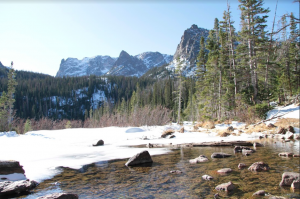
Odessa Lake – Elevation: 10,055 Feet (3,064.8 Meters)
Odessa Lakes is one of the coolest lakes in RMNP due to “Little Matterhorn” which looms over the lake. The stunning surrounding mountains combined with beautiful trees make this hike really gorgeous in all seasons. This is a horse riding destination, has fishing along the Big Thompson River and at the lake, an awesome boulder field, and more. It also has multiple routes, and easy access to nearby lakes.
This lake we kept in the intermediate category, but it is just border of the hard/difficult category. We kept it here because it has less than 2,000 feet of elevation gain, but this is the hardest hike in the intermediate category. Fern Lake, another on our list, is on the way to Odessa.
Odessa Lake
Trailhead: Fern Lake Trailhead or Bear Lake Trailhead
Difficulty: Intermediate
Distance: 8.9 miles miles round trip (14.32 km)
Elevation Gain: 1,900 feet (579.1 meters)
Duration: 5-7 hours (book time)
More Hiking Information: Hiking Odessa Lake
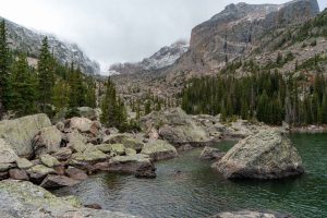
Mills Lake – Elevation: 9,940 Feet (3,029.7 M)
Mills Lake features stunning views of Longs Peak, and easy access to many of the other hikes on our list. With rocks to lay out on, beautiful trees, and wide open views, this is certainly a top destination in the park. The trail is easy to follow, doesn’t feature too much elevation gain, and is well marked.
Mills Lake Views
Trailhead: Glacier Gorge Trailhead or Bear Lake Trailhead
Difficulty: Intermediate
Distance: 5.6 miles miles round trip (9.01 km)
Elevation Gain: 780 feet (237.7 meters)
Duration: 3 to 5 hours (book time)
More Hiking Information: Hiking Mills Lake
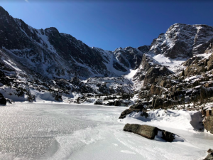
Lake Haiyaha – Elevation: 10,221 Feet (3115.36 m)
Lake Haiyaha features stunning surrounding peaks, deep water, and incredibly beautiful boulders surrounding the lake which make for perfect sitting areas, fishing spots, or lake jumping spots. The hike to the lake is beautiful, but the scenery within Chaos Canyon at this lake is simply stunning. This is another must do hike in this park.
 Distance: 3.9 miles round trip (6.28 km)
Height: 10,221 feet (3115.36 m)
Elevation gain: 865 feet (263.65 meters)
Duration: 2.5-3.5 hours (book time)
Difficulty: Intermediate
Trailhead Location: Bear Lake Trailhead (9,477 feet) – Secondary option: Glacier Gorge Trailhead
More Hiking Information: Hiking Lake Haiyaha
Fern Lake – Elevation: 9,540 Feet (2,907.8 meters)
Fern Lake is often combined with Odessa as you have to hike passed Fern Lake depending upon your trailhead location. We love this hike because of the sections along the Big Thompson River, a gradual gain most of the way, and then easy access to the nearby Odessa Lake.
Views of Fern Lake
Trailhead: Fern Lake Trailhead
Difficulty: Intermediate
Distance: 7.4 miles miles round trip (11.9 km)
Elevation Gain: 1,400 feet (426.7 meters)
Duration: 4 to 6 hours (book time)
More Hiking Information: Hiking Fern Lake
Best Difficult Hikes In Rocky Mountain National Park
Chasm Lake – Elevation: 11,823 feet (3,603.7 meters)
Chasm Lake is one of the most beautiful alpine lakes you’ll come across. The diamond rock face of Longs Peak is striking. The massive surrounding cliffs will make you feel small and insignificant. The blue water will humble you. The hike is difficult, but well worth it. It is a gradual gain nearly the entire way except for the last quarter mile where things get a bit more difficult. If you like alpine lakes, this is a must do in RMNP.
It is gorgeous in all seasons, but the last push in winter can be icy, so good microspikes are necessary.
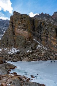
Chasm Lake
Trailhead: Longs Peak Ranger Station – 9,405 feet
Difficulty: Hard / Difficult
Distance: 8.4 miles round trip (13.52 km)
Elevation Gain: 2,500 feet (762 m)
Duration: 6 to 9 hours (book time)
More Hiking Information: Hiking Chasm Lake
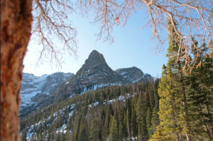
Longs Peak – Elevation: 14,259 feet (4,346 meters)
Simply put, this list wouldn’t be complete without Longs Peak on it. People will travel across the country just to climb this 14er, and it is no simple task for many. It is difficult, but stunningly beautiful, and the tallest peak in Rocky Mountain National Park. Don’t take this hike lightly, arrive early to the trailhead, and only attempt in good weather. Be sure to read our full guide on this mountain. Hikers only have to detour a little bit to also hit Chasm Lake, another hike on this list. It has class 3 hiking, meaning scrambling is required. This is not a recommended hike for the beginner, or anyone afraid of heights.
Chasm Lake from Longs Peak Summit
Trailhead: Longs Peak Trailhead
Difficulty: Very Difficult
Distance: 15 miles round trip (24.14 km)
Elevation Gain: 5,370 Feet (1636.8 meters)
Duration: 12 – 13 hours on average
More Hiking Information: Hiking Longs Peak
Sky Pond – Elevation: 10,900 feet (3,322.3 meters)
Sky Pond takes hikers passed Alberta Falls and Past Loch Vale, two other hikes on this list. In addition, the views at sky pond are extremely unique and striking. You’ll find this alpine lake to be special. The trail here is gradual and relatively easy until the last push where the trail gets very steep and wet due to a waterfall. This means it is slippery, and very icy in winter months.
Sky Pond Views
Trailhead: Glacier Gorge Trailhead or Bear Lake Trailhead
Difficulty: Hard / Difficult
Distance: 9.0 miles miles round trip (14.48 km)
Elevation Gain: 1,780 feet (542.5 m)
Duration: 6 to 8 hours (book time)
More Hiking Information: Hiking Sky Pond
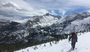
Flattop Mountain – Elevation: 12,324 Feet (3,756 M)
Flattop Mountain is one of our top hikes due to the crazy stunning views hikers experience above treeline. Early on, hikers get views of Hallett Peak and Longs Peak, but later on the views only get better.
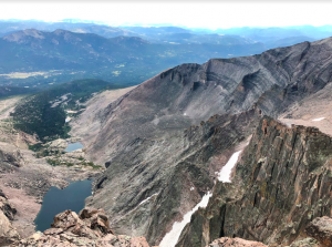
At one point, hikers stand atop a cliff looking down at Emerald Lake, another hike on this list. They then continue heading towards the Continental Divide, and have the option to continue further to Hallett Peak or turnaround. This is also a great winter or snowshoeing hike for those that want something more strenuous.
 Trailhead: Bear Lake Trailhead
Difficulty: Hard / Difficult
Distance: 8.9 Miles Round Trip (14.32 Km)
Elevation Gain: 1,780 feet (542.5 m)
Duration: 6 to 8 hours (book time)
More Hiking Information: Hiking Flattop Mountain

Max DesMarais is the founder of hikingandfishing.com. He has a passion for the outdoors and making outdoor education and adventure more accessible. Max is a published author for various outdoor adventure, travel, and marketing websites. He is an experienced hiker, backpacker, fly fisherman, trail runner, and spends his free time in the outdoors. These adventures allow him to test gear, learn new skills, and experience new places so that he can educate others. Max grew up hiking all around New Hampshire and New England. He became obsessed with the New Hampshire mountains, and the NH 48, where he guided hikes and trail runs in the White Mountains. Since moving out west, Max has continued his frequent adventures in the mountains, always testing gear, learning skills, gaining experience, and building his endurance for outdoor sports. You can read more about his experience here: hikingandfishing/about
-
Beauty
-
Parking
-
Trail Conditions