Simply put, New Hampshire has some of the best hiking in the country. In this article, we are going to lay out some of the best hikes in New Hampshire. Each will link to a full guide for that mountain, and we’ll also show you the key information about that hike. Before starting, if you are looking for our recommendation on the best easy hikes in New Hampshire, click here.
For your ease of use, we have grouped these hikes by difficulty, and also created hike finder resource if you are looking for even more hikes in New Hampshire.
Easy Hikes | Intermediate Hikes | Hard / Advanced Hikes
Easy Hikes
Mount Willard
 Mount Willard is one of the most rewarding short and easy hikes in NH. With only a gradual 1.6 miles to the cliff view of Crawford Notch, it is a prime destination for inexperienced, new, or even seasoned hikers.
Distance: 3.2 miles (5 km)
Difficulty: Easy
Duration: 1-2 hours
Elevation Gain: 908 Feet (277 meters)
Height: 2,865 feet (873 meters)
Read About Hiking Mount Willard
Mount Major
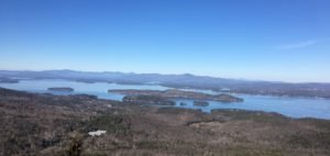 Mount Major is one of New Hampshire’s most hiked mountains. Just south of the White Mountains and Lake Winnipesaukee, it offers incredible views of the lake, Alton Bay, and the White Mountains to the north. On a clear day, Mount Washington is visible from the summit.
Difficulty: Easy/Moderate
Mileage: 4 Miles (6.4 km)
Hike Time: 1-3 Hours
Height: 1,786 feet (544.4 meters)
Elevation Gain (cumulative): 1,150 feet
Read About Hiking Mount Major
Champney Falls
 Champney Falls is a gorgeous waterfall hike located off of Route 112, the Kancamagus Highway. It is perfect for all hiking levels, and accessible in all season. The falls are often combined with a trip up Mount Chocorua.
Distance: 2.8 miles (4.51 km)
Difficulty: Easy
Duration: 2-3 hours
Read About Hiking Champney Falls
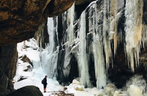
Arethusa & Or Ripley Falls
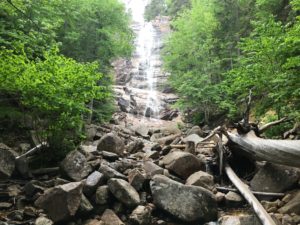 Both of these falls are stunningly beautiful and easy to get to in Crawford Notch. HIkers can choose to hike either or both of these waterfalls in a single day. Both are accessible by just about all levels.
Arethusa Falls: 2.6 miles round trip
Ripley Falls: 1 mile round trip
Arethusa & Ripley Falls Loop: 6.5 miles round trip
Read About Hiking Arethusa & Ripley Falls
Intermediate Hikes
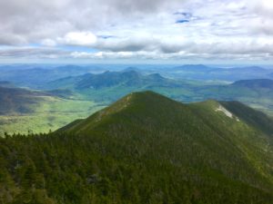
Mount Chocorua
This frequently trafficked mountain has one of the most unique summit profiles in New Hampshire. With numerous trails up containing waterfalls, cliffs, blueberries, lakes, and more, this is a must hike for anyone that loves visiting the White Mountains.
Height: 3,478 feet
Distance: 7.8-9 miles
Difficulty: Intermediate
Elevation Gain: 2,500 feet
Duration: 5-7 hours
Read about Hiking Mount Chocorua
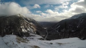
Mount Crawford
 Mount Crawford is one of the most spectacular hikes under 4,000 feet in the White Mountains. It parallels Mount Willard (also in Crawford Notch) with one of the best reward vs. effort ratios in the state of New Hampshire. Hikers begin by crossing the beautiful Saco River over a suspension bridge, and end at the summit with incredible views of Mount Washington, Crawford Notch and the unique Stairs Mountain.
Height: 3,119 feet
Distance: 5 miles
Difficulty: Intermediate
Elevation Gain: 2,106 feet
Hike Time: 2-4 hours
Read About Hiking Mount Crawford
Mount Jackson
Mount Jackson Views
From the open summit of Mount Jackson, you can see all of the southern presidentials and Mount Washington. Look to your east for views of the Dry River Wilderness along with Mount Isolation (4003’).
Height: 4,052 feet (1235.05 m)
Distance: 5.3 miles (8.53 km)
Elevation Gain: 2,150 feet (655.32 m)
Difficulty: Intermediate
Read About Hiking Mount Jackson
Mount Avalon
 This peak is on the easier side of the intermediate level hikes, but is a great option in Crawford Notch. It features fantastic views of Crawford Notch and the surrounding peaks.
Elevation: 3,430 feet
Elevation gain: 1,417 feet
Distance: 3.4 miles roundtrip
Duration (book time): 3 hours
Difficulty: Moderate
Mount Roberts
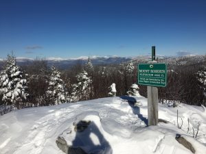
Mount Roberts is a 2,582 foot mountain located in the Ossipee Range in Moultonborough NH. Located at the Castle In The Clouds, it features gorgeous views of Lake Winnipesaukee, the southern White Mountains, and is part of the 52 with a view.
Height: 2,582 feet (787 m)
Distance: 5 miles (8.05 km)
Elevation Gain: 1,297 Feet
Difficulty: Easy
Duration: 2-4 hours
Read About Hiking Mount Roberts
Hard / Advanced Hikes
Mount Washington
As New England’s tallest peak, Mount Washington is known for the fastest winds on the planet, stunning beauty, backcountry skiing, climbing, hiking, the cog railway, and the Mount Washington auto road. On top of this, it has tons of amazing hiking routes to the summit.
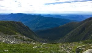
Height: 6,288 feet
Distance: 8.2 Miles
Elevation Gain: 4,186 feet
Duration: 5-10 hours (dependent on hiker’s ability)
Difficulty: Strenuous
Read about Hiking Mount Washington
Franconia Ridge
Franconia Ridge is one of New Hampshire’s classic hikes. The views from the ridge into Franconia Notch and the Pemi Wilderness are some of the best in the country. This is a popular hike even though it is considered strenuous.
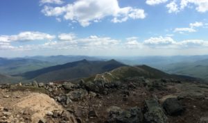
Mileage: 8.5 miles (3,700 feet of elevation gain)
Difficulty: Strenuous
Duration: 4-6 hours
Views: Incredible
Read about Hiking Franconia Ridge
Mount Moosilauke
Moosilauke rises seemingly by itself on the West side of New Hampshire’s White Mountains. The views are incredible at the top, but the waterfalls on the way up are just as incredible.
Height: 4,802 Feet
Rating: Difficult
Distance: 7.6 miles
Duration: 4-7 hours
Elevation Gain: 2,506 feet
Read about Hiking Mount Moosilauke
Bondcliff
Bondcliff takes a lot to get to (9 miles one way), but the views are arguable some of the best in all of the northeast. The large cliffs are a perfect spot to make you feel small above the vast Pemi Wilderness. This hike is a long day hike, but also wonderful to combine with overnight camping. Especially when combined with nearby peaks of Mount Bond and West Bond.
Height: 4,265 feet
Distance: 18.4 miles
Difficulty: Difficult
Elevation Gain: 3,100 feet
Duration: 6-10 hours (trail running: 3-6)
Read about Hiking Bondcliff
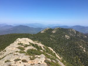
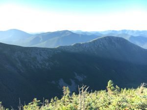
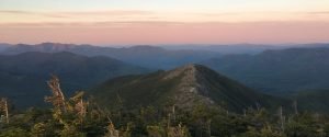
North & South Baldface
These mountains aren’t hiked that often when compared to the others on this list. They are tough, but this loop trail is one of the best loops in New England. These mountains may be the best on the NH 52 WAV list.
North Baldface Trail Views
Height: 3,566 feet
Distance: 9.5 miles
Difficulty: Difficult
Elevation Gain: 3,569 feet
Duration: 5-7 hours
Read about Hiking North & South Baldface
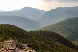
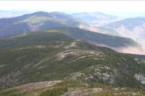
Mount Carrigain
Mount Carrigain (4,682 feet) is one of the most popular of the NH 48 due to its outstanding 360 degree views, and gorgeous ridge line trail. The summit features a fire tower with amazing views.
Signal Ridge from Mount Carrigain Summit
Height: 4,700 feet
Distance: 10 miles
Difficulty: Difficult
Elevation Gain: 3,250 feet
Duration: 5-8 hours
Read about Hiking Mount Carrigain
The Presidential Traverse
This isn’t a single mountain, it is a 22 mile traverse that includes New Hampshire’s highest peaks. A feat accomplished backpacking by most, but also frequently in a day by trail runners and experienced hikers. It is one of the most beautiful traverses in the country, and even features AMC huts and lakes along the way.
Distance: 21.7 Miles (34.9 km)
Elevation Gain: 8,800 feet (2682.24 meters)
Duration: 15 hours (dependent on hiker’s ability)
Difficulty: Strenuous
Read About Hiking The Presidential Traverse
The Pemi Loop
 The Pemigewasset Loop (pemi loop) is a 31 mile loop hike in New Hampshire’s White Mountains. The Pemigewasset Wilderness is surrounded by various hiking trails that make up the entire loop. Hikers will end up climbing at least 8 of NH’s 4000 footers, and gaining over 9,000 feet in elevation during the trip. The loop is most frequently hiked in 2 or 3 days, but some athletes tackle all the mountains in a single day hike.
Distance: 31 Miles (49.89 km)
Elevation Gain: 9,000 feet (2,743.2 meters)
Difficulty: Extremely Strenuous
Book Time: 20 Hours 17 Minutes
Read About Hiking The Pemi Loop

Max DesMarais is the founder of hikingandfishing.com. He has a passion for the outdoors and making outdoor education and adventure more accessible. Max is a published author for various outdoor adventure, travel, and marketing websites. He is an experienced hiker, backpacker, fly fisherman, backcountry skier, trail runner, and spends his free time in the outdoors. These adventures allow him to test gear, learn new skills, and experience new places so that he can educate others. Max grew up hiking all around New Hampshire and New England. He became obsessed with the New Hampshire mountains, and the NH 48, where he guided hikes and trail runs in the White Mountains. Since moving out west, Max has continued climbed all of the Colorado 14ers, is always testing gear, learning skills, gaining experience, and building his endurance for outdoor sports. You can read more about his experience here: hikingandfishing/about