Hall Ranch is an outdoor recreation destination featuring 13.6 miles of multi-use trail for hikers, trail runners, mountain bikers, and even horseback riders. Situated near the town of Lyons, CO on one of the routes to Rocky Mountain National Park, Hall Ranch features stunning views of Longs Peak and St. Vrain Canyon.
Height: Trailhead @ 5,550 feet (1776.4 meters) Summit @ 6,800 feet (2072.6 meters)
Distance: 9.77 miles (15.72 km)
Elevation Gain: 1,532 feet (466.9 meters)
Duration: 3 – 5 hours (dependent on hiker’s ability)
Difficulty: Moderate – Strenuous
Need to Know: No dogs allowed due to wildlife concerns.
Trails
Hall Ranch Suggested Loop: Nighthawk > Nelson > Bitterbrush
This 9.8 mile loop features a stunning view of S. St. Vrain Canyon, Longs Peak, and the Colorado Front Range. We suggest taking the Nighthawk trail to the eastern side of the Nelson loop and then descending via the Bitterbrush Trail. This way you will have a gradual ascent and will not be forced to finish your loop on a climb back to the parking lot.
Bitterbrush Trail
The 3.7 mile Bitterbrush trail begins at the main parking lot and quickly branches off to the right as you start hiking. It is moderately steep, but has lots of rocks where careful footing is necessary after the first half-mile or so. Once you reach the intersection with the antelope trail you’ve done more than half of the climbing and are rewarded with nice views of the front range. The remainder of the trail is a steady climb to the intersection with the Nelson Loop. This loop is popular for mountain bikers so make sure to keep your eyes peeled as you get closer to the intersection of these trails.
Button Rock Trail
This is a 2 mile single direction trail to the Button Rock Reservoir. It’s relatively flat. The quickest way to access it would be taking the Nighthawk trail from the main trailhead.
Nighthawk Trail
This 4.7 mile trail begins at the main parking lot and branches off to the left as you start hiking. It goes slightly uphill before making a 200 foot descent to the bottom of the valley floor. From here it’s about 1,000 feet of climbing to the intersection with the Button Rock trail. This trail does not feature much shade so make sure to put on some sunscreen and bring lots of water. Once you reach the alpine meadows though the 1,000ft of climbing becomes well worth it. Your reward for all that climbing is stunning meadows with beautiful flowers in the late spring and early summer framed by beautiful pines and a stunning view of longs peak.
Nelson Loop
This trail is a 2.2 mile loop with only 300 feet of rolling elevation, but appears to be a mountain bikers paradise. There are beautiful berms and lots of flow so watch keep your ears out for passing bikers. It is a quick three-quarter mile connector to the Bitterbrush trail if you are looking to complete the suggested loop. If not, it’s a very moderate 2 mile loop to add on some mileage to your hike.
Trail Map
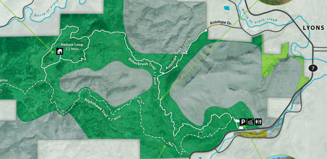
Hall Ranch Open Space Trail Map
Here you can view a PDF of the entire Hall Ranch Open Space: Hall Ranch Trail Map
Hiking in Winter
Hall Ranch is a great winter hiking destination. It sits at a moderate altitude and does not feature many trees, so unless a lot of snow has fallen recently, you should have a fairly clear trail. If you’re hiking between December and February watch out for ice on the trail, but don’t worry about bringing microspikes, there should only be a few patches.
Camping Information: Hall Ranch does not allow camping at any time of the year. It is a day use site only.
Current Weather Conditions
Here is a detailed forecast for the next four days:
Lyons, CO
Directions & Parking
There are two parking lots at the main trailhead for Hall Ranch. One is on the left side as you pull in and is located about 150 yards from the start of the hiking trails. The second is further along, slightly larger, and features a bathroom but no running water. The parking lot will fill up as the day goes on so make sure to get there early to secure a spot. If you don’t make it in time, there are spots to pull off along the road.
You can also start hiking off of Antelope Drive just west of downtown Lyons, but street parking is limited.
Here are directions to the main trailhead:
Here are directions to the Antelope Trailhead:
Paul Brastrom is an active outdoorsman from Houston, Texas. He recently completed his goal of climbing all of the Colorado 14ers and is continuing to spend his time in the Colorado Rockies. A digital marketer during the week and a mountain biker, splitboarder, rock climber, hiker, runner, and fly fisher when he’s not a work, Paul is at home in the mountains.