Mount Washington sits at 6,288 feet making it the tallest mountain in NH, and in all of the northeast. It offers incredible views, numerous hiking options, the famous Cog Railway, the Mount Washington Auto Road and even world record wind speeds. It is a top destination for travelers, hikers, skiers and climbers. Hiking Mount Washington is sure to be one of your most rewarding experiences.
Height: 6,288 feet (1916.58 meters)
Distance: 8.2 Miles (13.20 km)
Elevation Gain: 4,186 feet (1275.3 meters)
Duration: 5-10 hours (dependent on hiker’s ability)
Difficulty: Strenuous
Quick Navigation To Information On This Page:
Trail Options | Directions | Hike Time | Camping | Presidential Traverse
Need To Know Information
- Before making the trip up any trails of Washington, be sure to check the weather: https://www.mountwashington.org/experience-the-weather/mount-washington-weather.aspx. Keep in mind that the weather can change drastically from forecasts.
- Mount Washington is a serious hike and should only be attempted by those that are prepared with the right gear, experience, and knowledge.
- There are various different trails to the summit of Washington, we have highlighted most of them below so you can choose what is best for you.
- Hikers cannot reserve a one way van trip down when the road is open. This is first come first serve, and any hiker should be fully prepared to hike both ways, and should never expect to get a ride down.
Day Hiking Mount Washington
Fortunately, Mount Washington is relatively easy to drive to, and since roads come so close to the base, day hiking from numerous trails is extremely common. Below, trails are highlighted for the two most common starting locations: Pinkham Notch Visitor Center and the Ammonoosuc Ravine Trailhead.
Trail Options
Tuckerman Ravine Trail – (Starting at Pinkham Notch Visitors Center)
The Tuckerman Ravine Trailhead is located at the Pinkham Notch Visitors Center (directions below). The headwall of Tuckerman’s Ravine is at an elevation of 5,100 feet. This is one of the quickest and most traveled routes up Washington. It features a gorgeous waterfall right at the base, and a relatively simple and quick elevation gain to the summit. There are three main options when heading up from the Tuck’s trailhead. Each are described below (Lion Head, Tuckerman Ravine Trail, Huntington Ravine Trail):
Lion Head Trail – This features some fantastic views of Tuckerman Ravine from Lion Head, and is one of the fastest routes up Washington. This trail begins on the Tuckerman Ravine Trail and diverges to go up to Lion Head.
Trail Length – About 3.6 miles to summit for a round trip of just over 7 miles.
Elevation gain – 4,186 feet.
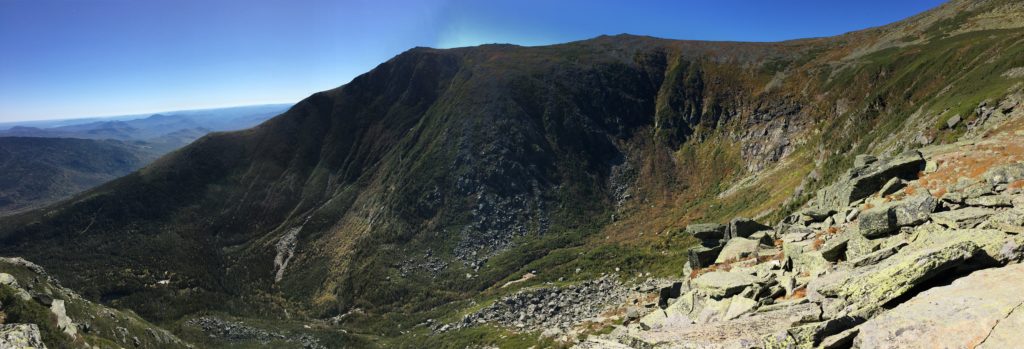
Views from Lion Head into Tuckerman’s Ravine
Tuckerman Ravine Trail – This also features great views of Tuckerman’s Ravine and of Lions Head. Sitting within the ravine and looking upwards to the headwall at the trail ahead is an incredible experience. Both trails are great options. Many often choose to go up one and down the other.
Trail Length – 4.1 miles to summit for a round trip of 8.2 miles.
Elevation gain – 4,186 feet.
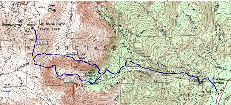
Highlighting the Tuckerman Ravine Trail, and the option to go up via Lion Head, or to continue along the Tuckerman Ravine Trail
Huntington Ravine Trail – This is one of the coolest trails in New Hampshire. It offers rock scrambling on some very large and steep rock sections. If you have a fear of heights, or are not confident on steep rock scrambling, this is not a recommended trail, but if you are, definitely do this trail! Most recommend not going down…but if your up for an adventure, it is quite fun. You can see it on the map above as it diverges from the Tuckerman Ravine Trail.
Trail length – 3.8 miles to summit (7.6 miles roundtrip)
Elevation gain – 4,186
Starting On The Cog Railway Side (Ammonoosuc Ravine)
There are two common options from the Cog Railway side. Each are described below:
Ammonoosuc Ravine Trail – This trail features large waterfalls along the Ammonoosuc River. It also brings you past the gorgeous lake of the clouds hut.
Trail length – 4.6 miles to summit (9.2 roundtrip)
Elevation gain – 3,540 feet
Jewell Trail – This is a great fast option for summiting Washington. This is a great trail for trail runners, and offers just a slightly different way up Washington. It also provides easy access to the other Presidentials and the Great Gulf Trail.
Trail length – 4.9 miles (add .3 ish if you are parking at the trailhead for the Ammonoosuc.)
Elevation gain – 2,788 feet
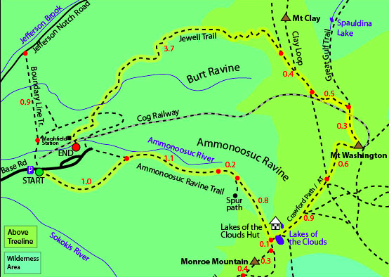
Highlighting the Ammonoosuc Ravine Trail and the Jewell Trail
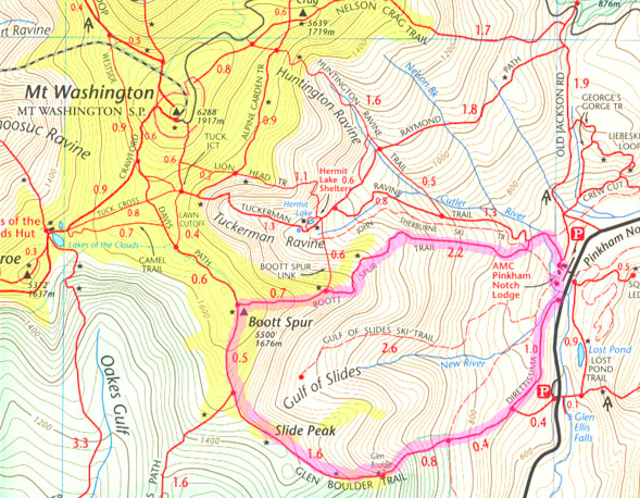
Boot Spur Trail to Washington
Boot Spur also can be accessed from Pinkham Notch starting on the Tuckerman Ravine trail. You can connect to it via the Tuckerman Ravine trail early on by taking a left less than a half mile into the Tuckerman Ravine trail. There is also the boot spur link trail that connects near hermit lake.
Trail Length – 6.2 to summit (12.4 round trip)
Elevation gain – 4,186
You can read more in depth reviews of each trail on All Trails to get a better idea of which path is best for you.
Camping and Overnight Hiking Options
There are a bunch of overnight options on the presidential range. You can view those options within the article in the link below.
https://hikingandfishing.com/presidential-traverse/
There are numerous tent sites available once you go down in elevation. You also have the option of camping at the nearby AMC Huts like Lake of the Clouds Hut.
The Presidential Traverse
Click here if you are interested in learning about hiking the whole presidential traverse (day hike or overnight).
Winter Hiking Mount Washington
Hiking in the summer can be dangerous enough as the rapid changes in weather on Washington can cause issues for those that are ill prepared. In the winter, it is absolutely crucial that you take the proper precautions when going out.
With this being said, hiking in the winter is one of the most rewarding and beautiful experiences. Not only will you avoid the summer crowds, but you will experience an incredible winter landscape that is unparalleled at any other time of the year. Many choose to hike the same trails that are popular in the summer, but do keep in mind the winter skiers traffic from Tuckerman Ravine.
Huntington ravine trail in the winter is strongly discouraged unless you are an experienced ice climber with the proper safety equipment. This trail is capable of taking the lives of even experienced individuals as conditions can be extremely dangerous.
How long does it take to hike Mount Washington?
| Route | Distance | Elevation Gain | Book Time |
|---|---|---|---|
| Round trip by Tuckerman’s Ravine | 8.4 | 4,300 | 6:20 |
| Round trip by Lion Head | 8.4 | 4,300 | 6:20 |
| Round trip by Boott Spur | 10.8 | 4,300 | 7:35 |
| Loop, Boott Spur and Tuckerman’s Ravine | 9.6 | 4,300 | 6:55 |
| Round trip by Ammonoosuc Ravine | 9.0 | 3,800 | 6:25 |
| Round trip by Jewell trail | 10.2 | 3,800 | 7:00 |
| Loop, Ammonoosuc Ravine and Jewell trail | 9.6 | 3,800 | 6:40 |
| Round trip by Great Gulf | 15.8 | 5,000 | 10:25 |
| Loop, Great Gulf and Tuckerman’s Ravine | 12.1 | 5,000 | 8:35 |
Directions
To Pinkham Notch Visitors Center Trailheads (Tuckerman Ravine, Huntington, Lion Head)
This is located off of Route 16 (White Mountain Road)
To Ammonoosuc Ravine Trailhead (Also Jewell)

Max DesMarais is the founder of hikingandfishing.com. He has a passion for the outdoors and making outdoor education and adventure more accessible. Max is a published author for various outdoor adventure, travel, and marketing websites. He is an experienced hiker, backpacker, fly fisherman, backcountry skier, trail runner, and spends his free time in the outdoors. These adventures allow him to test gear, learn new skills, and experience new places so that he can educate others. Max grew up hiking all around New Hampshire and New England. He became obsessed with the New Hampshire mountains, and the NH 48, where he guided hikes and trail runs in the White Mountains. Since moving out west, Max has continued climbed all of the Colorado 14ers, is always testing gear, learning skills, gaining experience, and building his endurance for outdoor sports. You can read more about his experience here: hikingandfishing/about
Skied Tuckerman's - Great Conditions
Tuckerman’s today was a blast! Solid snow conditions with some mashed potatoes on crust! We got white out conditions up high.