Hiking to Calloway Peak has three commonly used routes. The most famous route is the Profile Trail where you can see the Grandfather View (a rock bluff resembling a grandfather). Another choice is entering through the swinging bridge at Grandfather Mountain, a private attraction requiring a daily fee. The final trail is the Daniel Boone Scout Trail.
In this article we will provide a description of each, as well as directions to each of the main trailheads for each of these routes up Calloway Peak.
Distance – 8.1 miles roundtrip (13.04 km)
Height – 5,964 feet (1,817.83 m)
Elevation gain – 2,300 feet (701.04 meters)
Duration – 3.5 – 4 hours (book time dependant upon trailhead start)
Difficulty – Strenuous
Seasons – This hike can be completed in all seasons.
Trailhead Location – Profile Trail Parking Area on U.S. Hwy 105
Quick Navigation:
Routes | Trail Map | Camping Info | Weather | Directions | Pictures
Hiking Route Options
Profile Trail
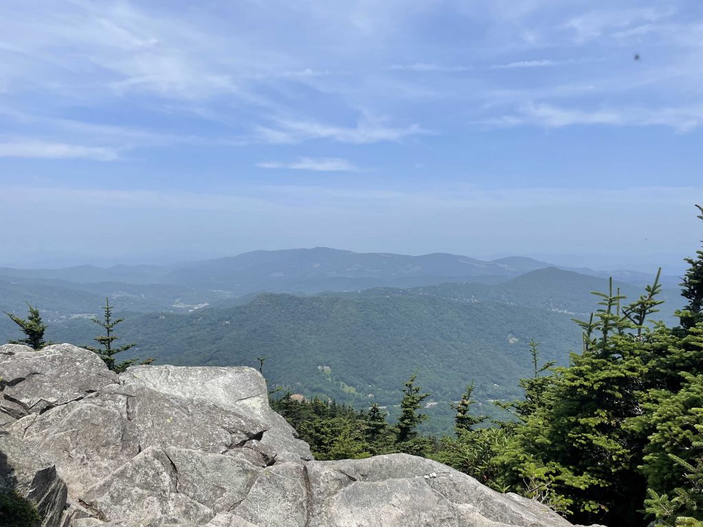
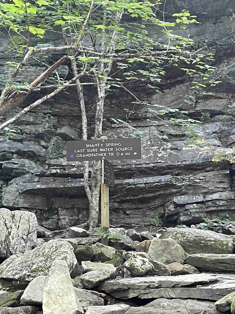
Grandfather Mountain’s Profile Trail to Calloway Peak is a strenuous trail. Fortunately, it ends close to the absolutely stunning and breathtaking Calloway Peak, one of the highest peaks in the Blue Ridge Mountains. Features of this hike include a rolling pathway through mountain wildflowers, a crossing over the Watauga River and two campsites at mile 2.5. As you would expect, this hike allows you to see some of the traits that inspired its name. The path becomes narrower around mile 1. As you reach Foscoe View it starts to get steeper. No worries as there are frequent rest stops with benches. When you reach mile 2.7 you will be at Shanty Spring, the beginning of the strenuous segment where the terrain transitions from hardwoods into the Canadian fir zone. Here you join the Grandfather Mountain Trail. Be careful as it is steep and rocky. Your reward is at the top of the mountain’s lofty ridge, Calloway Peak. Take three different wooden ladders to the top. After climbing the third one, make sure to go straight, following the trail and head around a big boulder where you climb to the Peak. Unfortunately, this is not clearly marked and many hikers don’t go all the way to the amazing view at the top.
However, as of 2021, a major trail reconstruction project has turned the last 3/10 mile from Shanty Spring to the summit ridge into a near-continuous set of beautifully arranged, flat stone steps! Though these were placed by trail machines rather than strictly by hand, they’re almost as aesthetically pleasing as the earlier sections (or will be once the rain washes a bit of the mud off) and designed to shed water at every opportunity.
Distance – 8.1 miles roundtrip (13.04 km)
Height – 5,964 feet (1,817.83 m)
Elevation gain – 2,300 feet (701.04 meters)
Duration – 3.5 – 4 hours (book time dependant upon trailhead start)
Difficulty – Strenuous
Seasons – This hike can be completed in all seasons.
Trailhead Location – Profile Trail Parking Area on U.S. Hwy 105
Need To Know Information
- Dogs are NOT allowed on this hike. Some people take dogs but they must be able to climb ladders.
- Camping is allowed at mile 2.5.
- A new trailhead parking lot was opened early summer of 2021. It adds some mileage to the Profile Trail.
- When you reach the third ladder at Calloway Peak, keep going along the trail. Follow around the left side of the large rock formation and climb up the back to the most spectacular summit. The peak is not marked.
The new Profile Connector is open effective July 15, 2021, after long-term construction. The connector offers additional trail mileage along the Profile Trail. The connector trail blaze is currently a florescent yellow diamond. The trailhead to access the Profile Trail and Profile Connector is located at 4198 NC Highway 105 North, Banner Elk, NC 28604.
Visitors seeking further information should call the park at 828-963-9522.
Grandfather Mountain Trail
Part of the Grandfather Mountain State Park but starts at the Mile-High Swinging Bridge (fee required) at Grandfather Mountain
People interested in going to the Mile-High Swinging Bridge at the Summit of Grandfather Mountain look no further. This trail runs from the Grandfather Mountain attraction to Calloway Peak along the summit ridge. The trail winds through wind-dwarfed fir and spruce, climbs pinnacles and across rock walls into open spaces with breathtaking views in all directions. There are extra-steep sections where in-place cables and ladders must be used and chutes where one must go hand-over-hand.
There is an admission fee, currently $20/person, to enter. The fee includes access to animal habitats, a nature museum, gift shop and restaurant. When you reach the summit of the mountain you will find the Mile High Swinging Bridge and after crossing this you can access Grandfather Trail. If you hike for 2.4 miles you will reach Calloway Peak. You can then take the Grandfather Trail to the Profile Trail back down or return the same way.
Things to Know
- You will need to arrange transportation back to your car if you don’t hike back the way you came. If a car enters Grandfather Mountain to pick you up the driver (and all occupants) will need to pay the entrance fee.
- Trail is not recommended for inexperienced hikers, pets or children.
- When you reach the third ladder at Calloway Peak, keep going along the trail. Follow around the left side of the large rock formation and climb up the back to the most spectacular summit. The peak is not marked.
Distance: 4.8 miles (7.72 km) roundtrip
Height: 5,964 ft
Elevation gain: 1872 ft
Duration: 5 hours
Difficulty: Advanced
Trailhead Location: End of the Mile-High Swinging Bridge in Grandfather Mountain attraction
Daniel Boone Scout Trail
This hike, which ascends about 2,000 feet, begins at the Blue Ridge Parkway’s Tanawha Trail and climbs to Calloway Peak. About halfway up, at Flat Rock View, hikers reach the junction of Cragway Trail. The upper half of the trail challenges the most experienced hikers but offers unforgettable views of Price Park and Linn Cove Viaduct. When reaching Calloway Peak, secured ladders and cables help hikers scale to the top. When you reach the third ladder, keep going along the trail. Follow around the left side of the large rock formation and climb up the back to the most spectacular summit.
Things to Know
- The upper section of the trail is not recommended for pets.
- When you reach the third ladder at Calloway Peak, keep going. Follow around the left side of the large rock formation and climb up the back to the most spectacular summit. The peak is not marked.
Distance 6 mi (9.67 km) roundtrip
Height 5,946 ft
Elevation gain 2,000 ft
Duration 4.5 hrs roundtrip
Difficulty strenuous
Trailhead Location Boone Fork Parking Area GPS: 36.120076, -81.781358
Camping Info
Many hikers choose to stay in the nearby towns of Banner Elk, NC or Boone, NC. You are able to hike on the Daniel Boone Scout Trail for 1.4 miles (2.3 km) to reach Daniel Boone Campsite. The average hiking time to the camping area is 1-1.5 hours. You are able to hike on the Daniel Boone Scout Trail for 2.1 miles (3.4 km) to reach Briar Patch Campsite. The average hiking time to the camping area is 1.5-2 hours. You are able to hike on the Daniel Boone Scout Trail for 2.8 miles (4.5 km) to reach Raven’s Roost Campsite. The average hiking time to the camping area is 2-2.5 hours.
Campfires are permitted in the stone fire ring provided at Daniel Boone and Briar Patch. Campfires are NOT permitted at the higher elevation site at Raven’s Roost. Campers must complete an on-site registration form at the Boone Fork Parking Area. Cost is $15/night (up to 6 campers) or $35/night (up to 12 campers). Reservations can be made at www.ncparks.gov or by calling 1-877-722-6762.
Trail Map
Camping For Grandfather Mountain / Calloway Peak
Many hikers choose to stay in the nearby towns of Banner Elk, NC or Boone, NC. You are able to hike on the Profile Trailhead for 2.5 miles to reach two remote campsites. The average hiking time to the camping area is 1.5-2 hours.
Campfires are permitted in the stone fire ring provided. The site is located 25 feet off of the trail. There are no tent platforms. There are cables to hang food across the trail from the campsite. A natural spring is located 0.75 mile above the campsite on the trail. It is recommended that you boil or filter all water. Campers must complete an on-site registration form at the Profile trailhead. Cost is $15/night (up to 6 campers) or $35/night (up to 12 campers). Reservations can be made at www.ncparks.gov or by calling 1-877-722-6762.
Current Weather Conditions:
The area is known for some of the South’s most severe weather. It is important to make sure that you check the weather. If it is raining usually this means thunderstorms. During the summer months daily rain outbursts often happen around 3 pm daily. Since this hike is rocky it is best to start early to avoid inclement weather.
Here is the detailed weather forecast for the next few days. We highly recommend you check out the mountain forecast for this peak the morning of your hike.
Grandfather, NC
Directions & Parking
Directions To Profile Trail
From the intersection of US 221 and NC 105 in Linville, NC, go North on NC 105 for 4.3 miles. The entrance to Grandfather Mountain State Park’s Profile Trail parking is on the right 0.3 mi past junction of Hwy. 184, beyond the ABC store.
From the intersection of US 221 and NC 105 in Boone, NC, it’s 12.6 miles South on NC 105 to the State Park entrance, on the left.
Follow the entrance road about 1/4 mile to the large new parking area for the Profile Trail. The State Park building with restrooms, a covered patio area, water, and a boot washing station marks the start of the trail.
Directions To Daniel Boone Scout Trail
The Boone Fork Parking Area for the Tanawha Trail/Daniel Boone Scout Trail is located on the Blue Ridge Parkway at Mile Marker 299.9.
Directions To Grandfather Trail
The entrance to Grandfather Mountain is located on U.S. 221, two miles north of Linville, North Carolina, and one mile south of the Blue Ridge Parkway at Milepost 305.
Address: 2050 Blowing Rock Highway, Linville, NC 28646.
GPS: 36.08502N, -81.84646W.
The road to the summit is referred to as Grandfather Mountain Entrance Road, Linville, NC.
Additional Pictures


Judy Wong from Charlotte, NC enjoys the outdoors, especially the mountains. She is currently attempting to climb all the highest peaks in the Smoky Mountains. She also dreams of completing at least 100 miles of the Appalachian Trail. As a mom of four Judy is currently career transitioning into a remote digital marketing role. Her hope is she can play in the mountains as much as she wants.