Clingman’s Dome is the highest point in in the Great Smoky Mountains National Park and features a .6 mile paved pathway to a stunning viewpoint. There are, however, several trails that intersect with the Clingman’s Dome Observation Trail. Below, we explain everything you need to know about this fantastic destination.
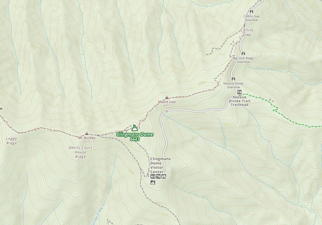
Clingmans Dome Observation Trail
This trail is paved but is a strenuous trail. It ends at the absolutely stunning and breathtaking observation tower which is the highest point in the Smoky Mountains. It is also said to be the highest point in Tennessee. On the top you will find a 360-degree view of both the Smokies and the beautiful spruce trees.
Hikers can park right at the trailhead for this trail here. (directions are also below)
Distance – 1.2 miles roundtrip (1.93 km)
Height: 6,640 Ft (2,023.87 meters)
Elevation Gain: 332 Ft (101.19 meters)
Duration: 1 hour
Difficulty: Easy
Seasons: April – November (Road is closed December – March)
Need To Know Information
- Dogs are NOT allowed on this hike. This is enforced.
- This is one of the most heavily visited places in the area. There is a parking lot and additional parking is available on the edge of the road.
- Weather can get chilly so bringing a jacket and other warm clothes is advised. Also, clouds and rainstorms after 3 pm in the summer are common.
- Although the trail is paved the path is not safe for wheelchairs or strollers. Bikes are not allowed.
Trail Maps
For Clingman’s Overlook Trail
For Other Hiking Options (click to enlarge)
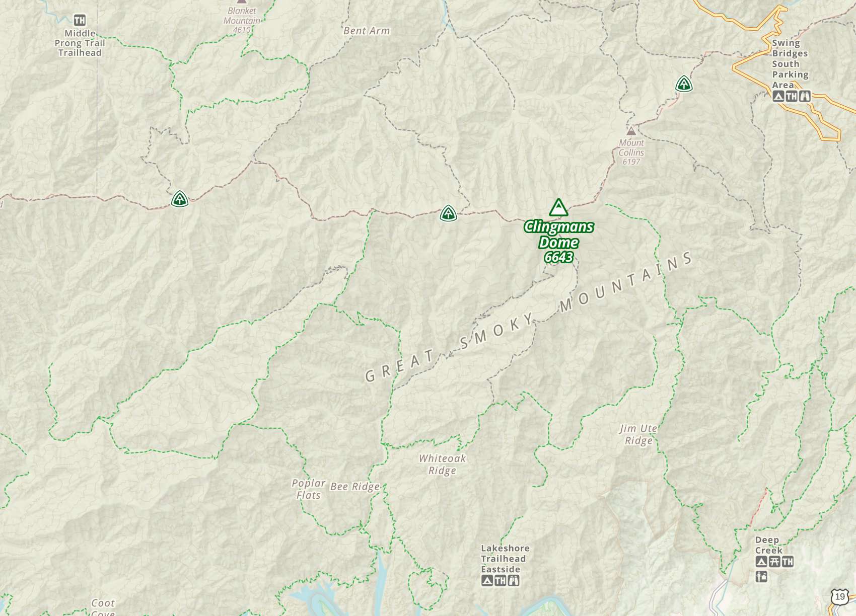
Other Hiking Route Options
Forney Ridge Trail
Distance – 23 miles (37 km) roundtrip
Elevation Gain: 4,878 Ft (1487 m)
Duration: 9-10 hours
Difficulty: strenuous and steep
Seasons: April – November
In order to access the trail take the trail marked Andrews Bald and it will lead to the Forney Creek Hiking Trail.
The Forney Ridge Trail joins the Forney Creek Trail on a strenuous 7.6 mile descent from Clingman’s Dome to the Jonas Creek Trail intersection.
Although one might choose this as an out-and-back, it’s part of a popular backcountry loop that continues up to Silers Bald on the Appalachian Trail and back to Clingman’s Dome for a total of 20.5 mile.
Begin through dense bands of Fraser fir and red spruce on the Forney Ridge Trail. This traverses steeply past the Clingman’s Dome Bypass Trail (.15 mile).
Forney Ridge develops some rugged stages to the Forney Creek Trail (1.0 mi). The path narrows as it steeply descends. In these grassy glades, rare for this area, you may be able to spot a turkey or brown bear.
The trail reaches the top of Forney Creek and then it turns downward as it transitions into an upper-hardwood forest.
The trail continues above and away from a creek into the heart of a northern hardwood forest. Rhododendron envelops portions of the trail while vines drape from maple, beech, and poplar. The understory is notably lush and diverse at these lower, wetter elevations.
The Forney Creek Trail meets the Jonas Creek Trail at a log bridge near the creeks’ junction.
Camping
- 5 primitive campsites (68, 69, 70, 71 & 74) along the entire trail (71 requires a reservation)
- 3 of the campsites are located on the upper end (68,69 & 70) and do not require a reservation
- Campsite 68 is recommended as it is moderately accessible to Clingmans Dome parking area
Jonas Creek Trail
The 4.1-mile Jonas Creek Trail in the Great Smoky Mountains is a challenging hike complete with scenic views and sporadic cascades.
This trail starts at the Forney Creek Trail to the trail’s completion at the Welch Ridge Trail.
So, in order to reach the Jonas Creek Trail, one must travel the Forney Creek Trail to the starting point.
Hikers cross a foot log over Forney Creek and cross Jonas Creek at 0.4 mile. This trail requires multiple wet creek crossings so be prepared. Some of the various trees you pass include sassafras, sourwood, oak, and American beech.
A 100-foot cascade that comes up on the right of the trail is very notable. After this spectacular view is a series of switchbacks before you start towards Yanu Ridge. The finale of the Jonas Creek Trail is reached at the junction with the Welch Ridge Trail.
Distance: 4.1 miles (6.6 km) one way up
Elevation Gain: 2,156 Ft (657 m)
Duration: 1.5-2 hours
Difficulty: strenuous and steep
Seasons: April – November
Nearby Hike: Andrews Bald
Looking to take a moderate hike when you’re at Clingmans Dome try the beautiful 1.8 mile out and back trail to Andrews Bald. It is a great combination of uphill and downhill with a good bit of flat area. There has been a lot of trail improvements and the moderate trail is easy to travel. When you reach Andrews Bald the view is spectacular as you traverse through a grassy marsh to the Bald itself.
Need To Know Information
- Dogs are NOT allowed on this hike. This is enforced.
- This is one of the most heavily visited places in the area. There is a parking lot and additional parking is available on the edge of the road.
- Weather can get chilly so bringing a jacket and other warm clothes is advised. Also, clouds and rainstorms after 3 pm in the summer are common.
Weather Information & Forecast
The area is known for some of the South’s most severe weather. It is important to make sure that you check the weather. Also, the road going up to Clingman’s Dome gets snow because of the high elevation. For that reason it is closed during the winter months (December to April)
Bryson City, NC
This Afternoon
Scattered showers and thunderstorms before 5pm, then scattered showers and thunderstorms. Mostly cloudy, with a high near 61. West wind around 10 mph, with gusts as high as 20 mph. Chance of precipitation is 50%. New rainfall amounts between a quarter and half of an inch possible.
Tonight
Scattered showers and thunderstorms before 8pm, then patchy fog and scattered showers and thunderstorms. Cloudy, with a low around 44. Northwest wind 5 to 10 mph. Chance of precipitation is 50%. New rainfall amounts between a tenth and quarter of an inch possible.
Saturday
Patchy fog before 11am. Mostly cloudy, with a high near 51. Northwest wind 5 to 10 mph.
Saturday Night
A chance of rain after 8pm. Mostly cloudy, with a low around 38. North wind around 10 mph. Chance of precipitation is 30%.
Sunday
Rain likely before noon, then rain showers likely. Cloudy, with a high near 43. North wind around 10 mph. Chance of precipitation is 60%.
Sunday Night
A chance of rain showers before 7pm, then a chance of rain between 7pm and 11pm. Mostly cloudy, with a low around 34. North wind around 10 mph. Chance of precipitation is 40%.
Monday
Mostly sunny, with a high near 49. North wind around 10 mph.
Directions
To Clingman’s Dome Parking Area for the Observation Trail:
Turn off Newfound Gap Road 0.1 mile south of Newfound Gap and follow the 7-mile-long Clingmans Dome Road to the large parking area at the end.
Clingmans Dome is 25 miles from Cherokee, NC or 23 miles from Gatlinburg, TN. The closest city to Clingmans Dome is Bryson City, NC.

Judy Wong from Charlotte, NC enjoys the outdoors, especially the mountains. She is currently attempting to climb all the highest peaks in the Smoky Mountains. She also dreams of completing at least 100 miles of the Appalachian Trail. As a mom of four Judy is currently career transitioning into a remote digital marketing role. Her hope is she can play in the mountains as much as she wants.