Mount Sneffels is a 14,150 foot peak in the Uncompahgre National Forest of Colorado and is a part of the San Juan Range. There are various routes to the summit of this 14er, some of which feature a rough 4 wheel drive road that takes hikers to above 12,000 feet.
Distance – 7.6 miles round trip (12.23 km) – Shorter with 4wd vehicles.
Height – 14,150 feet (4312.9 m)
Elevation gain – 3,560 feet (1085.09 m)
Duration – 5 to 8 hours (book time)
Difficulty – Strenuous
Class: Class 3 Hike
Seasons – This hike can be completed in all seasons, but winter is especially difficult, and dangerous.
Trailhead Location – Yankee Boy Basin Trailhead – 10,710 feet (directions below)
Trails
Starting from Yankee Boy Basin, hikers can take the road very high up to the 4 WD trailhead. There is also a 2 WD trailhead located at lower elevations. Only high clearance 4WD vehicles will make it to the 4 WD trailhead. 4WD vehicles without high clearance can make it past the 2WD trailhead even if they don’t make it all the way up. There are various pull-off / parking spots along the way up the road. Obvciously, the farther you make it, the shorter your hike becomes.
This road is really awesome. It is gorgeous, difficult, features amazing views, and is just plain fun in a jeep or truck.
Yankee Boy Basin Road – Standard Route Up Scree (Lavender Couloir) – Easy Class 3
4WD Car – 5.6 miles round trip – 1,716 feet of elevation gain
2WD Car – 7.6 miles round trip – 3,560 feet of elevation gain
This is the most common route up Sneffels. If starting at the lower 2WD trailhead, the hike to the 4WD trailhead is very simple up the road, or up side trails near the road.
After reaching the 4WD trailhead, hikers follow the well marked trail and hit the junction towards Blue Lake Pass. Hikers stay right and head slightly up towards the base of the scree field. Once reaching the scree field hikers should follow what they feel is the easiest route up the the scree field. Rock fall danger is a potential here, especially with hikers above you. Be careful, and you should be wearing a helmet.
Once reaching the saddle at the top of the scree field, hikers bear to left and head up Lavender couloir. Again, rockfall danger is here, and hikers should take the easiest path up the scree and boulder field being especially cautious for rockfall.
Once reaching the top of the couloir, hikers bear left once again to what is known as the Crux. This features a very short section of either a class 3 or class 4 more to reach the summit. We explain how to get over this in the images below. Follow the simple scrambles to the summit off to the right after passing the crux.
Yankee Boy Basin Road – Southwest Ridge – Via Blue Lake Pass – Class 3
4WD Car – 6.5 miles round trip – 1,742 feet of elevation gain
2WD Car – 8.5 miles round trip – 3,596 feet of elevation gain
This is a lesser traveled route to the summit of Sneffels and features a much longer portion of class 3 hiking along the ridge.
There is a faint trail along the ridge for hikers to follow but some route finding abilities will be helpful. We highly recommend checking out the images on 14ers.com for this route here.
Blue Lakes Trail – 4,939 Feet Elevation Gain – 11.74 Miles Round Trip – Class 3
This is a lesser common and longer route to Mount Sneffels. Hikers choose to do this route to also experience Blue Lakes Basin, which is gorgeous. Hikers will head to the blue lakes basin, and then switchback up to Blue Lake Pass before hiking the class 3 ridge to the summit of Sneffels.
Trail Map
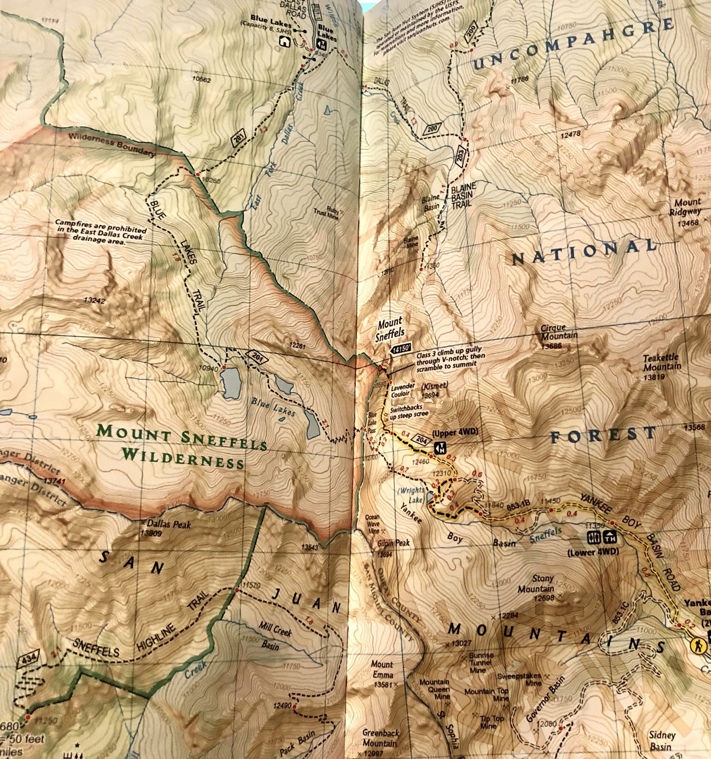
Mount Sneffels Trail Map
Hiking Mount Sneffels In Winter
As with any 14er, this hike is significantly more dangerous in winter. During the right time of year, the steep scree fields on the standard route become the best approach as the snow cover allows for easier hiking.
Camping For Mount Sneffels
There are various options for those summiting Sneffels from either approach. If you are looking to camp and hike from the Blue Lakes Basin, check here: https://www.fs.usda.gov/recarea/gmug/recarea/?recid=32558 There are also various dispersed camping areas in Yankee Boy Basin, meaning, hikers can camp within the basin. You can read more about camping in the Mount Sneffels Wilderness here: https://www.fs.usda.gov/recarea/gmug/recarea/?recid=80858
Current Weather Conditions:
Here is the detailed weather forecast for the next few days. We highly recommend you check out the mountain forecast for this peak the morning of your hike.
Telluride, CO
Today
Snow showers likely and a slight chance of thunderstorms after noon. Partly sunny, with a high near 37. South southwest wind 20 to 25 mph. Chance of precipitation is 60%. New snow accumulation of less than one inch possible.
Tonight
A chance of snow showers and a slight chance of thunderstorms. Mostly cloudy, with a low around 23. West southwest wind 20 to 25 mph. Chance of precipitation is 50%. New snow accumulation of 1 to 3 inches possible.
Friday
Snow showers likely before 9am, then snow showers and a chance of thunderstorms. Mostly cloudy, with a high near 33. Southwest wind around 25 mph. Chance of precipitation is 90%. New snow accumulation of 2 to 4 inches possible.
Friday Night
Snow showers and a chance of thunderstorms. Cloudy, with a low around 22. South southwest wind 5 to 25 mph. Chance of precipitation is 90%. New snow accumulation of 2 to 4 inches possible.
Saturday
Snow showers before 9am, then snow showers and a chance of thunderstorms. Cloudy, with a high near 28. West southwest wind 10 to 15 mph. Chance of precipitation is 100%. New snow accumulation of 4 to 8 inches possible.
Saturday Night
Snow showers likely and a chance of thunderstorms. Mostly cloudy, with a low around 22. Chance of precipitation is 60%. New snow accumulation of around one inch possible.
Sunday
Snow showers likely and a chance of thunderstorms. Mostly cloudy, with a high near 31. Chance of precipitation is 70%. New snow accumulation of 1 to 2 inches possible.
Directions & Parking
The lower trailheads are accessible for all vehicles, but the upper 4WD trailhead requires high clearance and 4WD.
Directions to Yankee Boy Basin Trailhead (4WD – Other vehicles can stop along the road before this trailhead):
The direction pin below is to Yankee Boy Basin even though Google says “Blue Lakes Trailhead Parking Lot” – this Google listing is wrong. We have submitted an update to Google to fix this. The coordinates of the trailhead are: 37.994874, -107.784831 for your own use.
Directions To Blue Lakes Trailhead
Additional Pictures
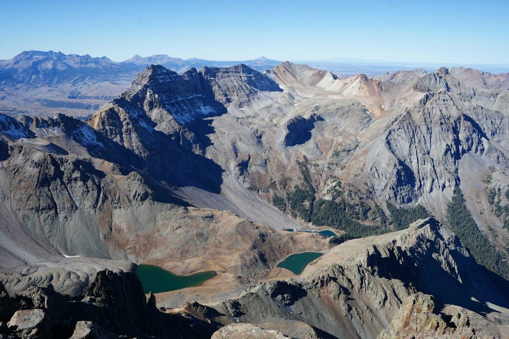
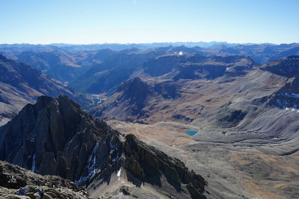
Blue Lakes Basin From Sneffels Summit
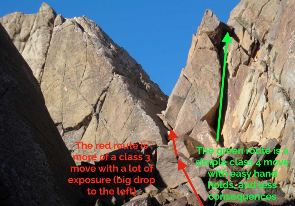
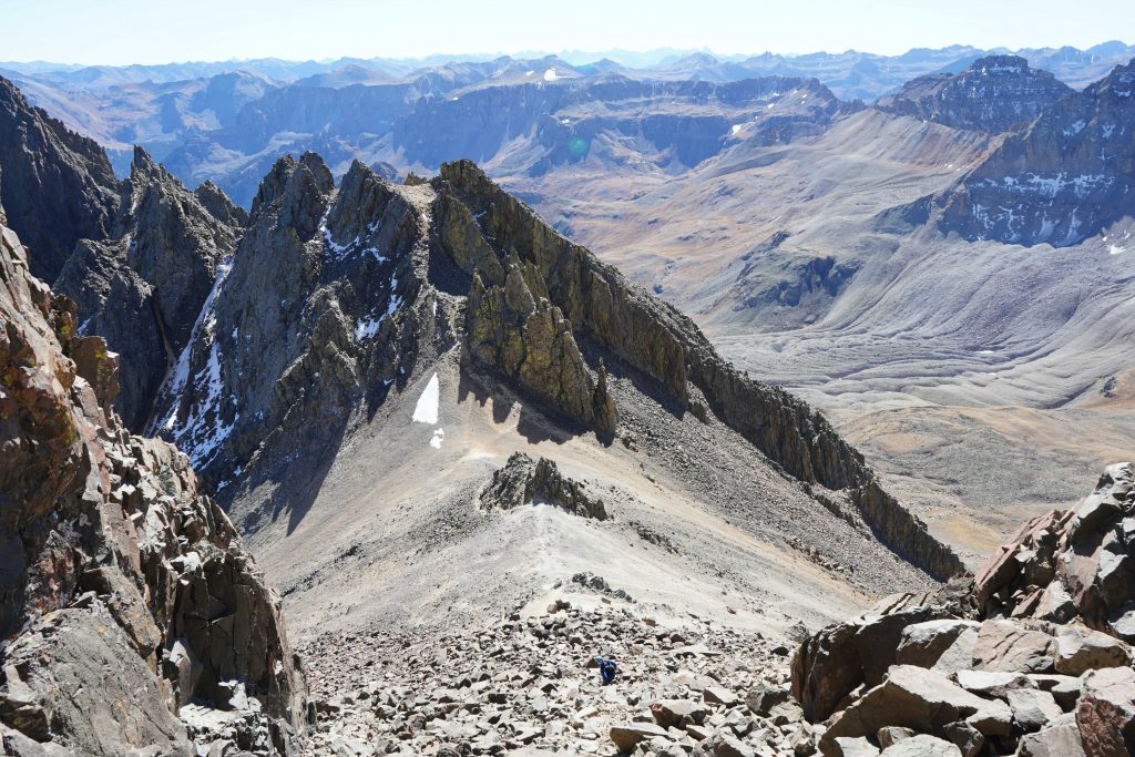
Mount Sneffels climbing section (the crux)
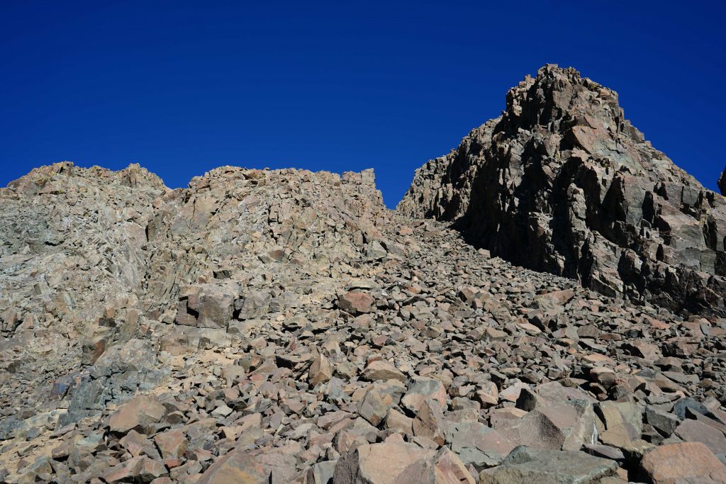
Looking up Lavender Couloir from saddle at the top of the scree field
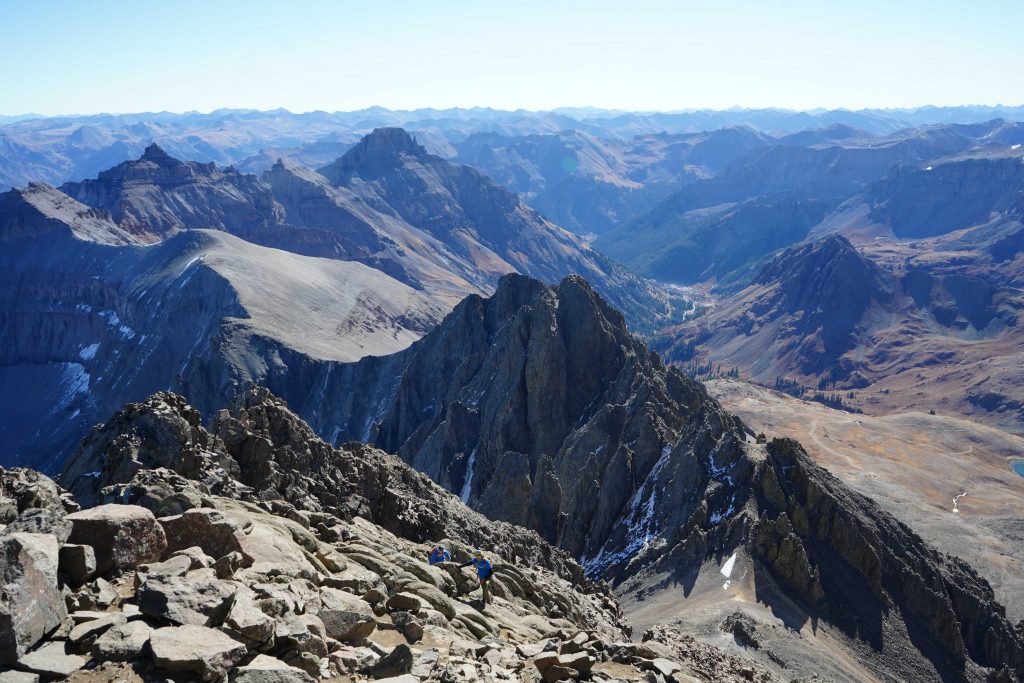
Mount Sneffels Summit Views
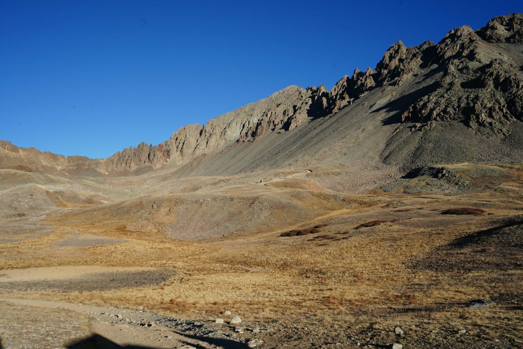
Yankee Boy Basin
Views from Mount Sneffels Summit
Viewing Scree Chute From Bottom Of Lavender Couloir
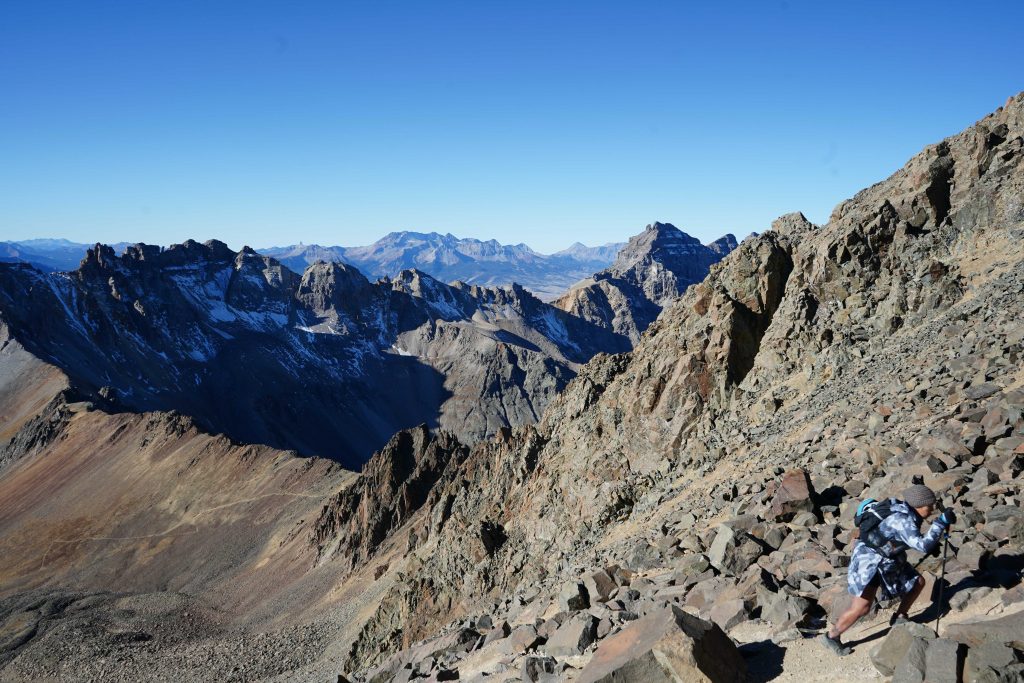
Photo from scree chute looking at the class 3 southwest ridge

Max DesMarais is the founder of hikingandfishing.com. He has a passion for the outdoors and making outdoor education and adventure more accessible. Max is a published author for various outdoor adventure, travel, and marketing websites. He is an experienced hiker, backpacker, fly fisherman, backcountry skier, trail runner, and spends his free time in the outdoors. These adventures allow him to test gear, learn new skills, and experience new places so that he can educate others. Max grew up hiking all around New Hampshire and New England. He became obsessed with the New Hampshire mountains, and the NH 48, where he guided hikes and trail runs in the White Mountains. Since moving out west, Max has continued climbed all of the Colorado 14ers, is always testing gear, learning skills, gaining experience, and building his endurance for outdoor sports. You can read more about his experience here: hikingandfishing/about