Mt. Ellen’s wooded summit stands at 4,083 feet (1,244 m) in the middle of Vermont’s rightfully named Green Mountains. The Long Trail travels over its prominence. Because the east side of the mountain is part of the Sugarbush ski area, extensive views in all directions can be attained just a short walk from the summit itself. Mt. Ellen is usually a fairly quiet summit in the summer, but can be busy (due to ski crowds) in the winter. There are three possible approach trails to the summit; Jerusalem Trail, Long Trail from Lincoln Gap, and Long Trail from Appalachian (App) Gap.
Height: 4,083 feet (1,244 meters)
Distance: 8.6 miles round trip (13.8 km)
Elevation Gain: 2600 ft. (792 m)
Duration: 5-6 hours depending on hiker’s ability (Jerusalem Trail)
Difficulty: Difficult
Hike Class: Class 1
Other routes described below have different mileages and elevation gains.
Please note: Hiking on the Long Trail and in Vermont’s Green Mountains is not recommended after the winter season until the end of May due to trail erosion caused by mud season hikers. Please see https://anr.vermont.gov/node/943 for more information.
Trails
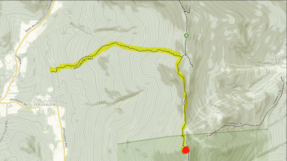
Jerusalem Trail – 8.6 miles (13.8 km) – 2600 ft. (792 m) elevation gain
The shortest route to Mt. Ellen’s summit – the Jerusalem Trail climbs steadily before joining the Long Trail south of the Mt. Ellen summit. The steady climb makes this hike feel a bit more difficult than one would expect.
Once ascending to the ridge, views get quite nice. This is also probably the best winter ascent option.
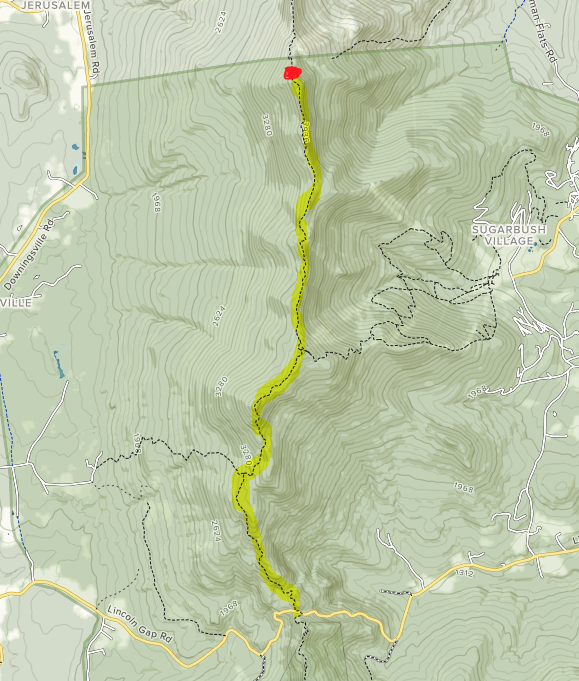
Long Trail from Lincoln Gap – 12.6 miles (20.3 km) – 3250 ft. (991 m) elevation gain
Following the Long Trail from the highest point on Lincoln Gap Rd. will lead you over Mt. Abraham and several other summits before reaching the Mt. Ellen Summit after 6.3 miles. There are quite a few “ups and downs” on this route, but expansive views are offered in many occasions.
This route is the most heavily trafficked trail due to hikers being able to combine this hike with Mt. Abraham. This route has the best reviews from hikers heading up Mount Ellen. It features no river crossings to be concerned about. The road closes in the winter, and this is not the recommended winter route. Gorgeous views from Mt. Abraham and Lincoln Peak along the way.
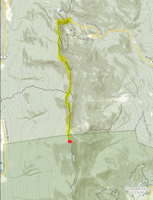
Long Trail from Appalachian (App) Gap – 10.8 miles round trip (17.1 km) – 2200 ft. (671 m) elevation gain
Following the Long Trail from Appalachian (better known as App) Gap will lead you from the Sugarbush Access Road south for 5.3 miles on the Long Trail over General Stark Mountain and a few minor peaks to Mt. Ellen. Views along this ridge are prevalent and change with each turn. This is the lesser traffic route to the summit, though it is frequented by AT through hikers.
This is not the recommended winter route.
Other options: Other less-popular options for approaching Mt. Ellen are a Lincoln Gap to App Gap traverse (car spotting required) or combining either Gap trail with the Jerusalem Trail (car spotting required). One could also hike up the ski trails from the Sugarbush Ski Area, but this is not recommended.
Trail Maps
Below, we have a trail map for each of the above routes.
Mount Ellen Trail Map: Appalachian Gap
Mount Ellen Trail Map: Jerusalem Trail
Mount Ellen Trail Map: Lincoln Gap Approach
Hiking in Winter
Microspikes, snowshoes and winter gear will be required to climb Mt. Ellen in the winter. Road conditions for the Lincoln Gap or Appalachian Gap approaches should be checked prior to planning a winter hike. All routes can be done in winter, though the Jerusalem trail is likely the easiest and safest option.
Camping Information
Glen Ellen Lodge (managed by the GMC), located 0.2 miles off a spur trail from the Long Trail between General Stark Mountain and Mt. Ellen, offers primitive accommodations for 8 people. A fee may be required in the summer. There is no electricity, running water or heat in the rustic cabin, but there is a stream nearby (use filter). A composting outhouse is available a short walk from the lodge.
Battell Shelter (managed by the GMC) is a good option for those taking the Lincoln Gap approach. The shelter is located between Mt. Abraham and and Lincoln Gap. A caretaker may be present to collect a fee during the summer season.
Theron Dean Shelter (managed by the GMC) is a good option for those taking the App Gap approach and offers a great view from a nearby ledge. The three-sided shelter can fit 6-8 people. Water here is limited.
You can read more about these shelters at the Green Mountain Club’s site.
Current Weather Conditions
Waitsfield, VT
Tonight
A chance of rain and snow showers before 3am. Cloudy, with a low around 34. South wind around 15 mph. Chance of precipitation is 50%. New rainfall amounts less than a tenth of an inch possible.
Friday
A chance of rain showers after 3pm. Mostly cloudy, with a high near 47. South wind 15 to 30 mph. Chance of precipitation is 30%. New rainfall amounts less than a tenth of an inch possible.
Friday Night
A chance of rain showers before 3am, then a chance of rain and snow showers. Mostly cloudy, with a low around 34. Southwest wind 17 to 31 mph. Chance of precipitation is 50%. New rainfall amounts between a tenth and quarter of an inch possible.
Saturday
A slight chance of rain and snow showers. Partly sunny, with a high near 41. West wind 17 to 25 mph. New rainfall amounts less than a tenth of an inch possible.
Saturday Night
A slight chance of rain showers before 8pm, then a slight chance of rain and snow showers between 8pm and 10pm. Mostly cloudy, with a low around 29. West wind 16 to 26 mph.
Sunday
Mostly sunny, with a high near 41. West wind 13 to 18 mph.
Sunday Night
Mostly clear, with a low around 28. West wind 20 to 37 mph.
Directions & Parking:
Jerusalem Trail: Take exit 9 off I-89N towards US-2/Middlesex/Moretown/VT-100. Drive 0.2 miles and turn left onto Center Road. Drive 0.1 miles and turn left onto US-2 East. Drive 0.6 miles and turn right onto Vermont 100B South. Drive 7.9 miles and continue straight on VT-100 S/Main Street. Continue to follow VT-100 South for 5.4 miles and take a slight right onto VT-17 West. Drive 12.2 miles and turn left onto Jerusalem Road. Drive 0.7 miles and turn left onto Jim Dwire Road. The parking lot is about 0.5 miles on the right side of the road.
Long Trail from Lincoln Gap: From Jim Dwire Road (see above), turn left onto Jerusalem Road. Drive 0.8 miles and continue on Downingville Road. Drive 3.6 miles and turn left onto Quaker Street. Drive 0.9 miles and take the third left onto E River Road. Drive 1.1 miles and continue onto Lincoln Gap Road. Drive about 3.5 miles to the Lincoln Gap parking lot on the right side of the road.
Long Trail from Appalachian (App) Gap: The Appalachian Gap parking area can be found on VT Route 17 in Buels Gore.

Ashley Spooner is an avid outdoors-woman from Thornton, NH. She has completed all of New Hampshire’s 48 4,000 Footers, the 273-mile Long Trail in Vermont, and the 100-Mile Wilderness in Maine. Ashley has also climbed all of the 4000 footers in Maine, including Katahdin numerous times, and has spent years hiking and backpacking in environments ranging from the Arctic Circle in the Lofoten Islands of Norway to the slot canyons of Utah and Arizona. She has also spent time hiking and backpacking in Montana, Oregon, California and Colorado. She holds a Master of Natural Resources degree and Sustainable Natural Resources Management Graduate Certificate from Oregon State University and currently works in Forestry for White Mountain National Forest (USFS).