Piper Mountain is in the Belknap Range in Gilford, NH. It is neighbored, and often combined with Belknap Mountain, and Whiteface Mountain. This hike features various routes to summit (explained below), a rock seat at the summit, and great views of Lake Winnipesaukee.
Distance: 2.8 Miles Round Trip (4.51 km)
Height: 2,030 Feet (618.7 meters)
Elevation Gain: 962 feet (293.5 meters)
Difficulty: Easy to intermediate
Duration (Hike Time): 2 hours
Piper MountainTrails
Piper Mountain Trail (Lower Carriage Road) – 1.4 Miles To Summit – 963 Feet Elevation Gain
This is the most common route to the summit, and is accessible year round. The trailhead, is located just after the gate on Carriage Road (directions below) so hikers can park in the parking area and walk a couple hundred feet to the trailhead which is located just after the road bridge on the right.
Hikers will quickly cross a small creek and footbridge early on in the hike.
The trail features a gradual gain with a few moderately steep sections heading towards the summit. There is only one path all the way to the summit, so the trail is easy to follow and is well traveled.
White Trail (Upper Carriage Road) – From End of Belknap Mountain Road – .81 Miles To Summit – 392 Feet Elevation Gain
This route begins off of Carriage Road after the gate. (See GPS parking below). This is a short route to the summit, and can be driven to in summer months. In winter months, the road is closed, and hikers must start below.
This trail features gradual gains to the summit of Piper.
From End of Belknap Mountain Road – 3.2 Miles Round Trip – 1,270 Feet Elevation Gain
This is a fantastic option that begins at the end of Belknap Mountain Road (directions below). There is no official parking area here, but many choose this route if they are looking to avoid the other hikers on Carriage road, or want to combine Piper Mountain with Whiteface.
This trail features gradual gains to the summit, is well traveled, and easy to follow. Hikers begin on the trail, between two residential properties and continue straight.
Hikers will bear left at the only junction known as the Piper-Whiteface Link, which will take them to the summit of Piper. If hikers go right, they will be heading towards Mount Whiteface.
Trail Map
Download Full Map Here:
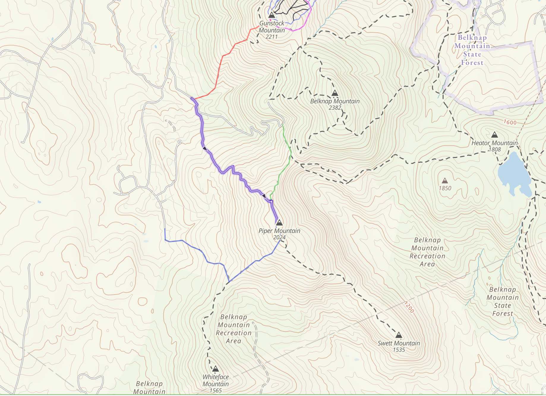
Piper Mountain Trail Map
Alternate Routes
Hikers may also choose to hike Belknap Mountain in a loop with Piper. Belknap, Gunstock, and Piper are also a common way to summit. There are tons of trails for hikers to choose from, so you can make your own path as long as you understand your abilities and navigation. Take a look at the full Belknap Range trail map provided above.
Directions
To Lower Carriage Road Trailhead (Belknap Range Trails)
To Upper Carriage Road
To End of Belknap Mountain Road (Whiteface Trailhead)
Weather Forecast
Belmont, NH
This Afternoon
Scattered rain showers. Cloudy, with a high near 48. South wind 5 to 10 mph. Chance of precipitation is 50%. New rainfall amounts less than a tenth of an inch possible.
Tonight
Scattered rain showers before 2am. Cloudy, with a low around 37. Southeast wind around 5 mph. Chance of precipitation is 40%. New rainfall amounts less than a tenth of an inch possible.
Friday
Mostly cloudy, with a high near 51. Southeast wind 5 to 15 mph.
Friday Night
Scattered rain showers after 9pm. Cloudy, with a low around 42. South wind 10 to 15 mph, with gusts as high as 25 mph. Chance of precipitation is 40%.
Saturday
Scattered rain showers before 2pm. Mostly cloudy, with a high near 55. West wind 10 to 15 mph, with gusts as high as 30 mph. Chance of precipitation is 40%.
Saturday Night
Mostly clear, with a low around 35.
Sunday
Mostly sunny, with a high near 51.
Additional Pictures
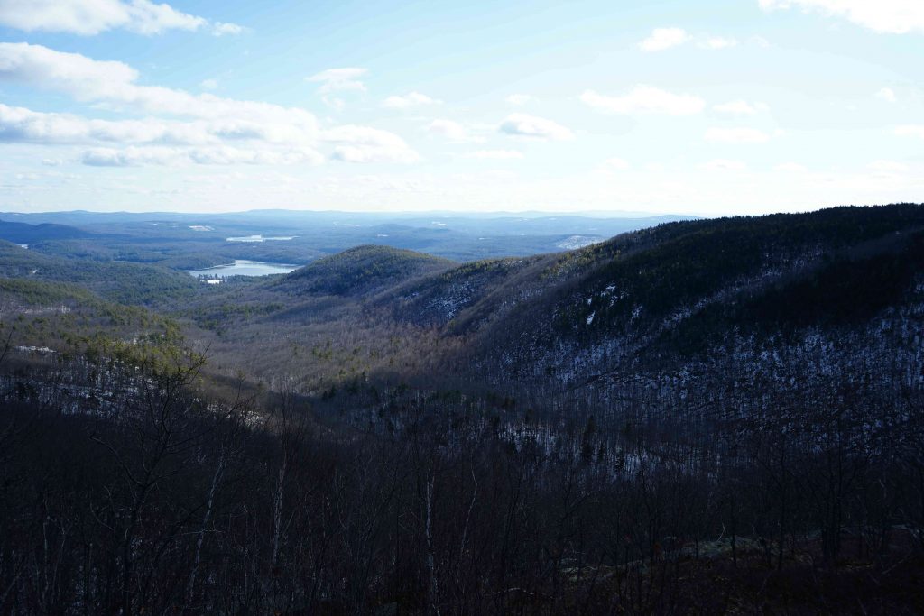
Mount Piper From Mount Belknap

Max DesMarais is the founder of hikingandfishing.com. He has a passion for the outdoors and making outdoor education and adventure more accessible. Max is a published author for various outdoor adventure, travel, and marketing websites. He is an experienced hiker, backpacker, fly fisherman, trail runner, and spends his free time in the outdoors. These adventures allow him to test gear, learn new skills, and experience new places so that he can educate others. Max grew up hiking all around New Hampshire and New England. He became obsessed with the New Hampshire mountains, and the NH 48, where he guided hikes and trail runs in the White Mountains. Since moving out west, Max has continued his frequent adventures in the mountains, always testing gear, learning skills, gaining experience, and building his endurance for outdoor sports. You can read more about his experience here: hikingandfishing/about
-
Beauty
-
Parking
-
Trail Conditions
Great Conditions - Only Small Amount Of Mud
Little saturday hike up Piper. Trails were overall in good shape, with some spots of mud that was easy to walk around. Definitely some downed trees and branches form the recent snow storm.