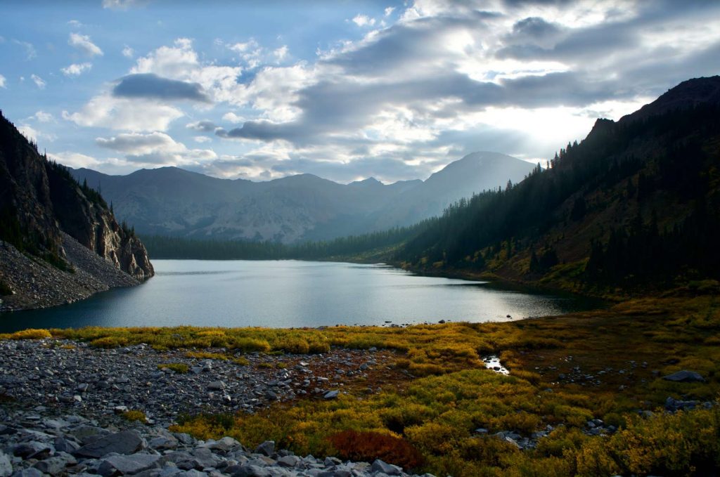
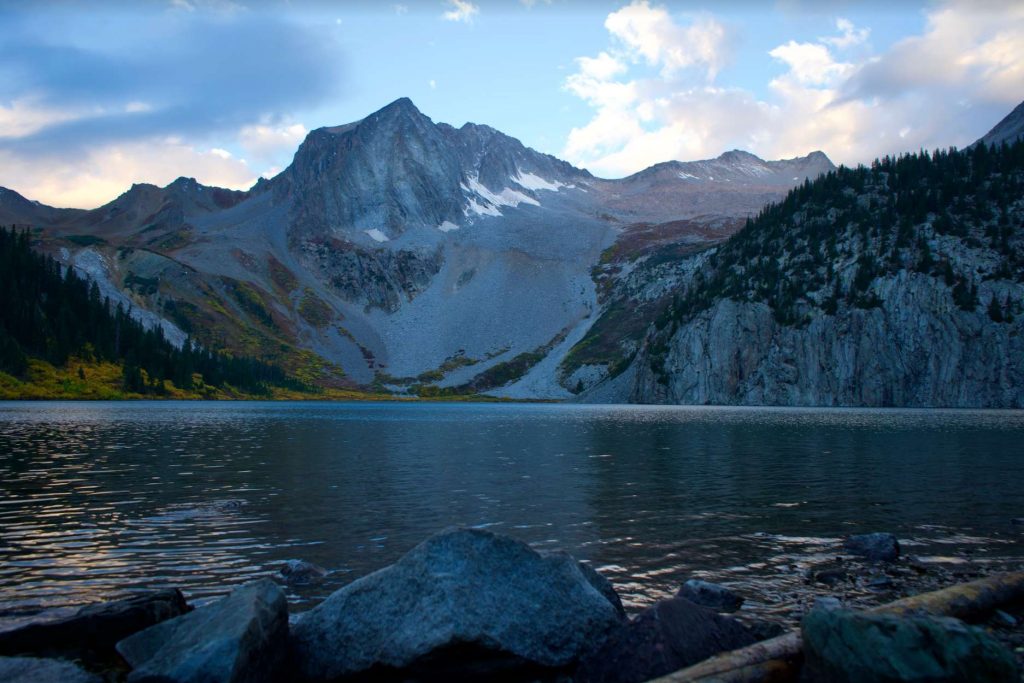
Snowmass Lake is one of the most beautiful high elevation lakes you’ll ever come across. It features stunning views of ridgelines, Snowmass Mountain, giant cliffs overlooking the lake, wildlife, and more. The lake has a designated camping area, incredible fishing and a gorgeous river. Here we will give you all the info you need to hike to this lake, or camp out.
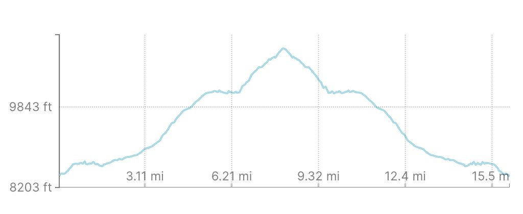
Distance – 16.6 miles round trip (26.07 km)
Height – 10,980 feet (3346.7 m)
Elevation gain – 3,873 feet (1180.49 m)
Duration – 10 to 13 hours (book time)
Difficulty – Strenuous
Class: Class 2 Hike
Seasons – This hike can be completed in all seasons. Extra gear and precautions need to be taken in winter.
Trailhead Location – Maroon – Snowmass Trailhead – 8,400 feet (directions below)
Trail Map
We have put together a map for you to view on Gaia here:
You can also view our trail map here (click to enlarge):
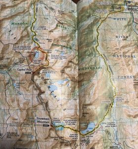
Snowmass Mountain Trail Map
Trail Description
Maroon Snowmass Trail: 16.2 Miles Round Trip | 3,873 Feet Elevation Gain | Class 2
This is the most common route to Snowmass Lake (some alternate options explained below). This route begins at the Maroon Snowmass trailhead through private property where hikers encounter 3 gates within the first 2 miles of the hike. Across the first two miles very little elevation gain occurs. Hikers simply remain on the Maroon Snowmass Trail which stays close to Snowmass Creek nearly the entire duration to Snowmass Lake.
Within the first 3-4 miles there are various dispersed campsites along the trail, some of which are traveled enough to appear to be the true trail but are not. Remember to simply take the trail that stays closest to the Maroon Snowmass Trail, except for 1.3 miles in when hikers reach the marked junction towards the West Snowmass Trail.
6.3 miles in, hikers will reach a log jam created at the end of a pond. Here, hikers cross the log jam to the other side of the water and follow the well established trail. In high water, the crossing is a little more difficult, but generally, the logs make for a pretty easy crossing. Be extra careful because it is easy to get a wet boot, or twist an ankle during this crossing.
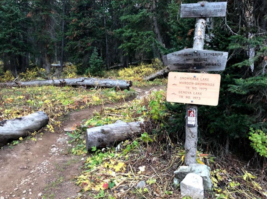
8 miles in, hikers reach a junction that is well marked. Here, follow the signs and trails towards Snowmass Lake, not towards Geneva Lake or the Maroon Snowmass Trail.
8.1 miles in, and 2,580 feet higher from your starting point (plus some ups and downs), you’ll reach Snowmass Lake and some absurdly stunning views. You can see the summit of Snowmass from here.
If you want to continue hiking further, you can head on to the summit of Snowmass (a lot further) or just hike around the lake or a big higher on the nearby trails. We highly recommend exploring around if you are doing an overnight.
Hiking Snowmass Lake in Winter
Snowmass Lake is not an easy hike even in the best of weather. With snow, you can be slowed down significantly. Some of the steeper sections will require that you at least have traction on you, microspikes or snowshoes.
You’ll experience far less people in winter,
Camping For Snowmass Mountain & Lake
There are dispersed campsites near the trail at numerous points before hikers reach Snowmass Lake. The best sites are near Snowmass Lake where there are many of dispersed sites. Backpacking permits are necessary, and the area does have bears, so having proper bear equipment and storage is necessary.
Permits are free and self serve at the trailhead. Before going, you should read about permits and camping locations here: https://www.fs.usda.gov/recarea/whiteriver/recarea/?recid=40555
Current Weather Conditions:
Here is the detailed weather forecast for the next few days. We highly recommend you check out the mountain forecast for this the morning of your hike. You can check weather at different elevations. The base may be drastically different than the lake, and the lake may be drastically different from the summit of Snowmass Mountain.
Snowmass Village, CO
Overnight
Partly cloudy, with a low around 26. West wind 10 to 15 mph. Little or no snow accumulation expected.
Tuesday
A slight chance of snow showers and a slight chance of thunderstorms between noon and 4pm, then a slight chance of rain and snow showers. Mostly sunny, with a high near 43. West southwest wind 15 to 20 mph. Chance of precipitation is 20%.
Tuesday Night
Partly cloudy, with a low around 28. Southwest wind around 15 mph.
Wednesday
Sunny, with a high near 46. West southwest wind 15 to 20 mph, with gusts as high as 35 mph.
Wednesday Night
Mostly clear, with a low around 26. Southwest wind 15 to 20 mph.
Thursday
Snow showers likely and a slight chance of thunderstorms after noon. Mostly sunny, with a high near 41. Chance of precipitation is 60%. New snow accumulation of less than half an inch possible.
Thursday Night
A chance of snow showers and a slight chance of thunderstorms. Mostly cloudy, with a low around 22. Chance of precipitation is 50%. New snow accumulation of 1 to 2 inches possible.
Directions & Parking
The road leading to the trailhead is great up until the last mile or so. Any high clearance vehicle should have no problem with this road. Some portions of the road should be driven cautiously with 2wd or low clearance vehicles.
Directions to Maroon Snowmass Trailhead
Additional Pictures
Snowmass Lake From Base of Scree Field
Snowmass Lake
Trail Junction Before Snowmass Lake

Max DesMarais is the founder of hikingandfishing.com. He has a passion for the outdoors and making outdoor education and adventure more accessible. Max is a published author for various outdoor adventure, travel, and marketing websites. He is an experienced hiker, backpacker, fly fisherman, backcountry skier, trail runner, and spends his free time in the outdoors. These adventures allow him to test gear, learn new skills, and experience new places so that he can educate others. Max grew up hiking all around New Hampshire and New England. He became obsessed with the New Hampshire mountains, and the NH 48, where he guided hikes and trail runs in the White Mountains. Since moving out west, Max has continued climbed all of the Colorado 14ers, is always testing gear, learning skills, gaining experience, and building his endurance for outdoor sports. You can read more about his experience here: hikingandfishing/about