Wilson Peak is an iconic summit quite possible most well known as the mountain that the Coors Banquet logo, and now Coors Light packaging design is based off of. This peak in the San Juan mountains is stunning, features some incredible views into the Lizard Head Wilderness, and is a great class 3 hike. Here we will give you everything you need to know to hike Wilson Peak.
Distance – 9.12 miles round trip (14.68 km)
Height – 14,016 feet (4272.08 m)
Elevation gain – 4,191 feet (1277.42 meters)
Duration – 10 – 12 hours (book time dependant upon trailhead start)
Difficulty – Strenuous
Class: Class 3 Hike
Trailhead Location – Rock Of Ages Trailhead, Navajo Lake Trailhead, Kilpacker Trailhead, or Woods Lake Recreation Area
Quick Navigation:
Routes | Trail Map | Camping Info | Weather | Directions | Pictures
Need To Know Information
-
- Wilson Peak has several different approaches, but each approach takes the Southwest Ridge (class 3) for the final portion of the hike to the summit. We will explain the details for each of these approaches below.
- Dispersed camping is allowed in Lizard Head Wilderness, but be sure to read on the rules and regulations here: https://wilderness.net/visit-wilderness/?ID=329
- This is a class 3 hike with solid exposure, so it should only be completed by those that have experience dealing with other class 3 mountains.
Hiking Route Options
There are several routes that all take hikers to Wilson’s Southwest Ridge. We will explain all of these options below. All three routes feature the same class 3 route to the summit which features fun scrambling, exposure, and great views. The route is well traveled, and well cairned, making route finding relatively simple, but of course preparation and route finding skills need to be used for this hike.
Rock Of Ages Trailhead | 9.12 Miles Round Trip (14.68 km) – 4,191 Feet Elevation Gain (1277.42 meters) | Class 3
This is a fantastic and simple day hike route. Much of this approach is on a well traveled trail, and then a road which makes this route options extremely simple compared to some of the other options.
The trailhead is located on Forest System Road 645(Elk Creek Road), is 4WD accessible, and features dispersed camping along the road, making this a common single day approach for Wilson Peak. This road is easy for 4wd vehicles with good clearance, and 2wd vehicles will likely need to stop 1.2 miles from the trailhead and find parking due to some creek crossings that will require decent clearing.
Hikers begin by hiking south on the Rock Of Ages Trail (#429) heading south, and quickly reach a junction with a gate where they bear left. I little over a mile in, hikers bear left along the trail that leaves Elk Creek Basin and heads up the ridge between Silver Pick Basin. Once getting in Silver Pick Basin, hikers will be along a road that heads up through the basin. The remainder of this approach is obvious to the saddle below Wilson Peak.
Navajo Lake Trailhead | 15.58 Miles Round Trip (25.07 km) – 5,529 Feet Elevation Gain (1685.24 meters) | Class 3
This route is our most recommended route for spending the night out and turning this into a backpacking trip. The trail is very well maintained and traveled, features incredible fields with insane views, waterfalls, streams (with fishing), and kicks hikers out at Navajo Lake, a perfect camping and fishing area. This is a great basecamp for summiting Wilson Peak, or hitting all three 14ers in one backpacking trip. It is worth noting that if you plan to hike El Diente, and to the El Diente Mount Wilson Traverse, the route to El Diente is extremely bad, filled with loose rock, scree, and has extreme rockfall danger. Because of this, many hikers choose to take this route to Wilson Peak ony, and then do the El Diente Mount Wilson Traverse as a separate trip via the Kilpacker Basin Trailhead.
The approach to this trailhead on the Forest Road (FR) 535 and is accessible via 2wd vehicles. This is a well traveled dirt road that is reasonably well maintained. 5 Miles into the road, hikers will reach the Kilpacker trailhead, and will continue two more miles before hitting the Navajo Basin Trailhead.
Kilpacker Basin Trailhead | 18.08 Miles Round Trip (29.10 km) – 5,882 Feet Elevation Gain (1792.83 meters) | Class 3
This route is one of the more difficult routes for summiting only Wilson Peak, but this has become the preferred route to summit El Diente and Mount Wilson. Therefore, if day hiking, or only hiking Wilson Peak, we don’t necessarily recommend this route. The approach is beautiful, simple, and features some ups and downs. When summiting Wilson Peak, hikers starting at this trailhead end up meeting up with the Navajo Basin trail about 3.4 miles into the hike.
The approach to this trailhead on the Forest Road (FR) 535 and is accessible via 2wd vehicles. This is a well traveled dirt road that is reasonably well maintained.
From Woods Lake Recreation Area | 16.06 Miles Round Trip (25.85 km) – 6,135 Feet Elevation Gain (1869.95 meters) | Class 3
This trailhead is located close to the Woods Lake Campground, which makes it a great option for campers wanting to stay in that area. This is accessible for 2wd vehicles.
Trail Map
Camping For Wilson Peak
There are various camping options available for each of the trail options. It is worth noting that camping options for this hike are in the Lizard Head Wilderness, so those regulations need to be followed, but this does mean that dispersed camping is readily available.
The most common camping areas are by Navajo Lake where there are many dispersed camping areas. You’ll also find plenty of people car camping at each of these trailheads. Because this is wilderness, there will be dispersed camping available on just about any approach to Wilson Peak.
Fishing Navajo Lake
There are lots of fish in Navajo Lake. Taking a fly rod is highly recommended as they will eat almost any dry fly in summer months.
Current Weather Conditions:
Here is the detailed weather forecast for the next few days. We highly recommend you check out the mountain forecast for this peak the morning of your hike.
Ophir, CO
Overnight
Mostly clear, with a low around 28. Southwest wind 20 to 25 mph.
Thursday
Isolated snow showers between 11am and noon, then a chance of snow showers and isolated thunderstorms. Mostly sunny, with a high near 30. Southwest wind 15 to 25 mph. Chance of precipitation is 60%. New snow accumulation of around one inch possible.
Thursday Night
A chance of snow showers and a chance of thunderstorms. Mostly cloudy, with a low around 21. West southwest wind 20 to 25 mph. Chance of precipitation is 50%. New snow accumulation of 1 to 3 inches possible.
Friday
A chance of snow showers before noon, then snow showers and a chance of thunderstorms. Mostly cloudy, with a high near 26. West southwest wind 20 to 30 mph. Chance of precipitation is 80%. New snow accumulation of 1 to 3 inches possible.
Friday Night
Snow showers and a chance of thunderstorms. Cloudy, with a low around 18. South southwest wind 15 to 30 mph. Chance of precipitation is 90%. New snow accumulation of 3 to 7 inches possible.
Saturday
Snow showers before 9am, then snow showers and a chance of thunderstorms. Cloudy, with a high near 21. Chance of precipitation is 100%. New snow accumulation of 4 to 8 inches possible.
Saturday Night
A chance of snow showers and a chance of thunderstorms. Mostly cloudy, with a low around 18. Chance of precipitation is 50%. New snow accumulation of around one inch possible.
Directions & Parking
Directions To Rock Of Ages Trailhead:
Directions to Navajo Lake Trailhead:
Directions To Kilpacker Basin Trailhead:
Directions To Woods Lake Recreation Area:
Additional Pictures
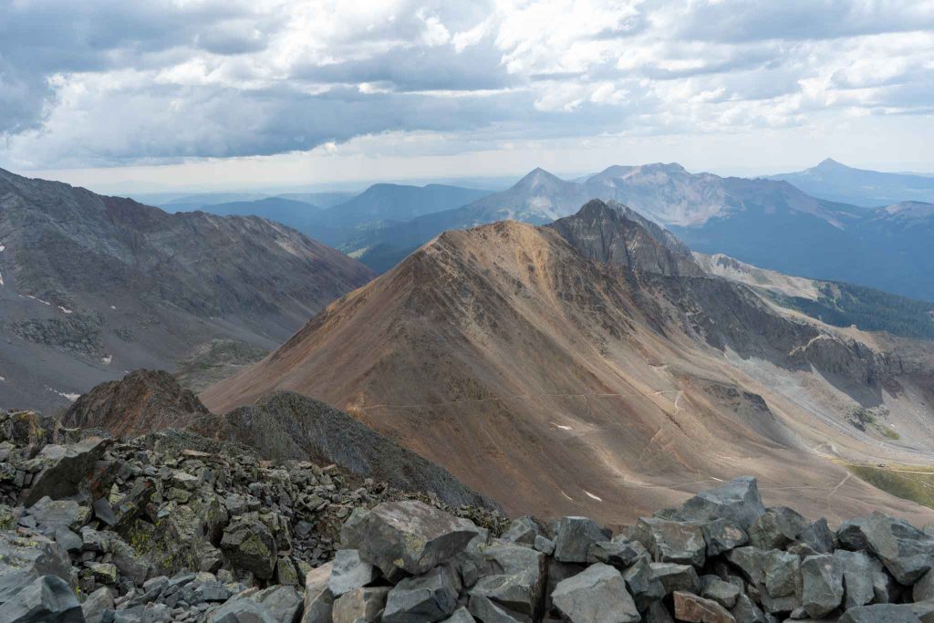
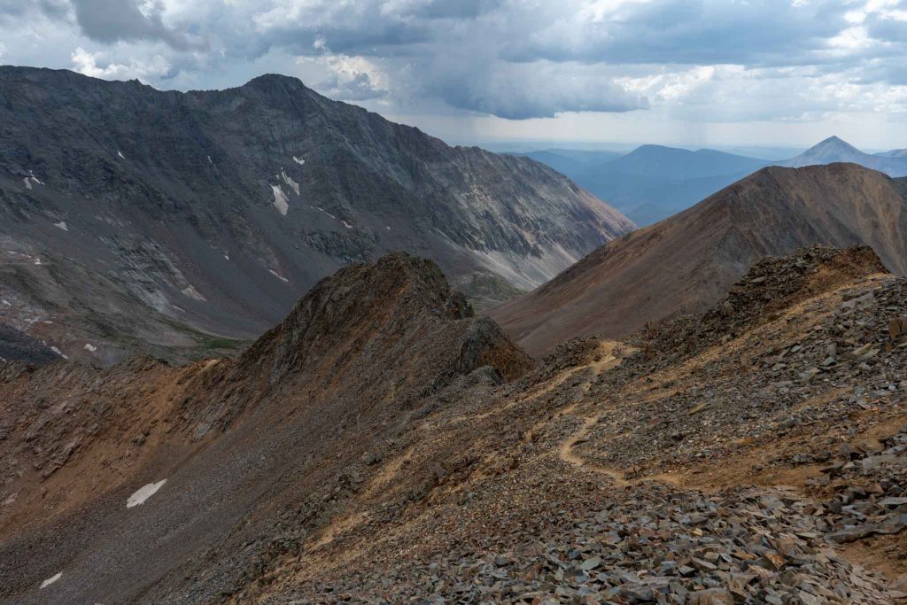
Views of rock of ages approach from summit of Wilson Peak
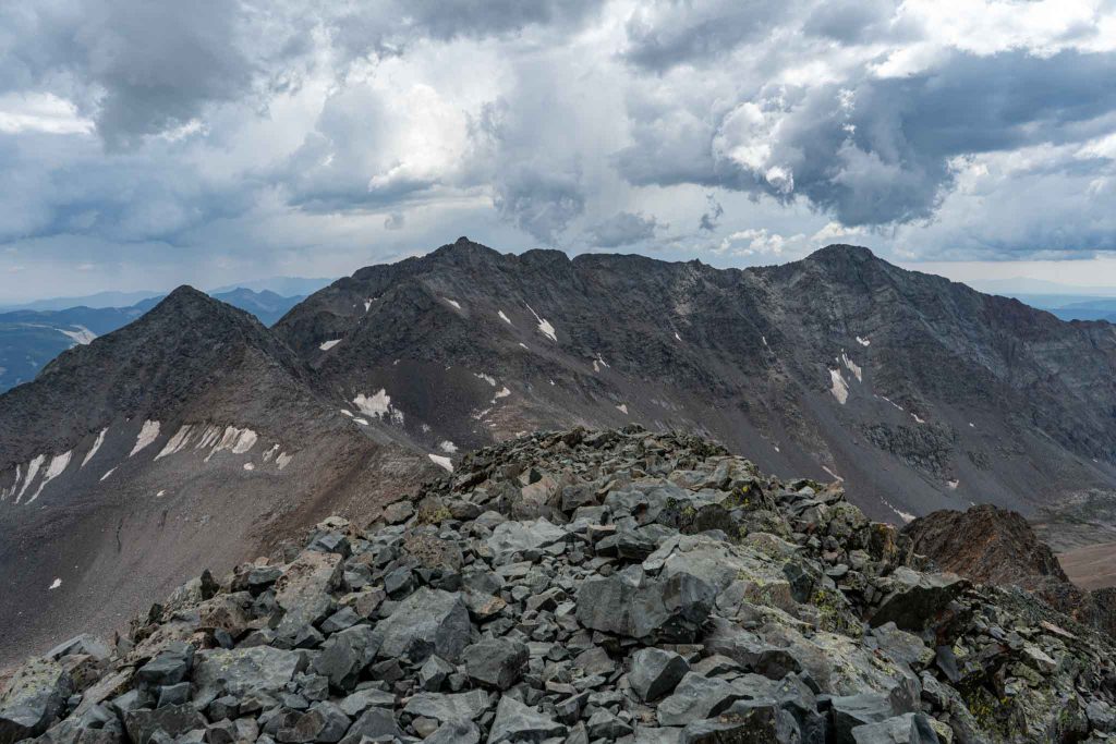
Views of Mount Wilson, El Diente traverse from Wilson Peak
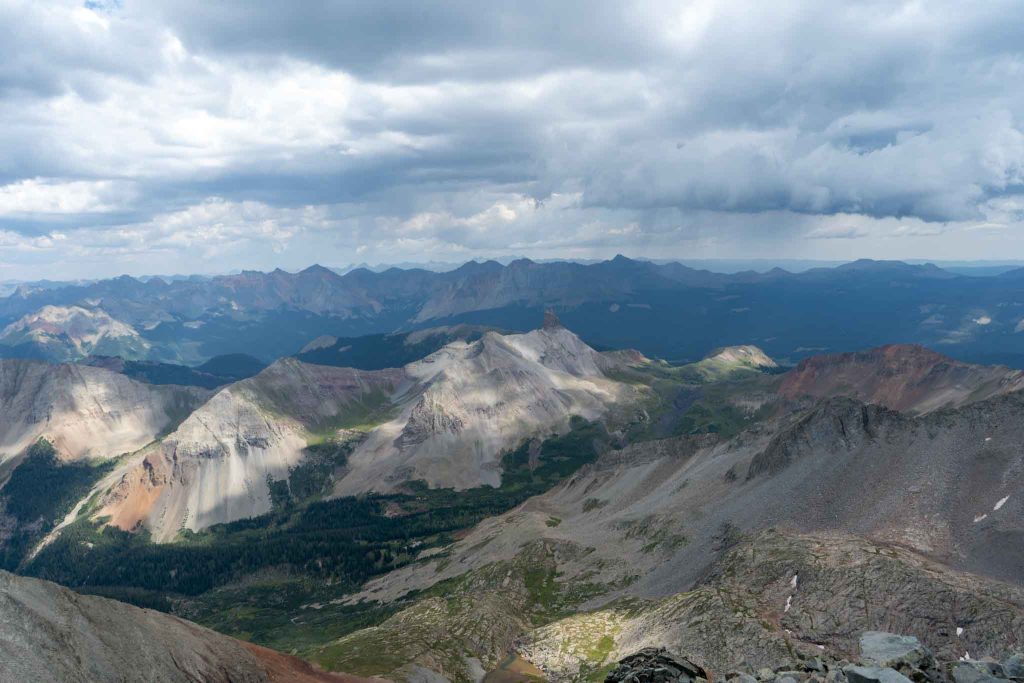
Views of Lizard Head Wilderness
Reaching the saddle where the Navajo Lake approach meets with the Rock Of Ages approach
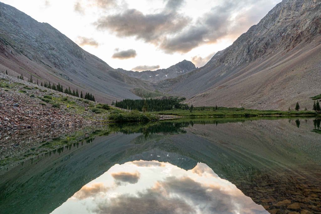
Views of Navajo Lake
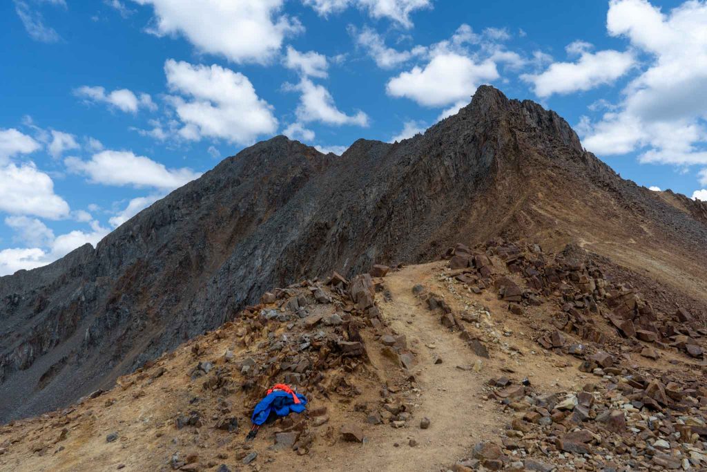
Views looking down on route below Wilson Peak

Max DesMarais is the founder of hikingandfishing.com. He has a passion for the outdoors and making outdoor education and adventure more accessible. Max is a published author for various outdoor adventure, travel, and marketing websites. He is an experienced hiker, backpacker, fly fisherman, backcountry skier, trail runner, and spends his free time in the outdoors. These adventures allow him to test gear, learn new skills, and experience new places so that he can educate others. Max grew up hiking all around New Hampshire and New England. He became obsessed with the New Hampshire mountains, and the NH 48, where he guided hikes and trail runs in the White Mountains. Since moving out west, Max has continued climbed all of the Colorado 14ers, is always testing gear, learning skills, gaining experience, and building his endurance for outdoor sports. You can read more about his experience here: hikingandfishing/about