Mount Monadnock is a 3,165 foot mountain located in New Hampshire. It is the highest peak in Southern New Hampshire and also the highest point in Cheshire County. Mount Monadnock is ranked one of the most hiked mountain in the world.
Quick Navigation:
Hike Stats | Trail Map | Trail Options | Camping | Parking & Directions
Elevation: 3,165 feet (964.69 meters)
Elevation gain: 1,748 feet (532.79 meters)
Distance: 3.8 miles round trip (6.12 km)
Duration (book time): 3-4 hours
Difficulty: Moderate
Need To Know Information:
- Reservations are recommended for Monadnock State Park. See details and make reservations here.
- There is a state park fees required: Parking Day Pass Fee: $15 + $1 transaction fee – See details here: https://www.nhstateparks.org/visit/state-parks/monadnock-state-park
- Dogs are not permitted in the state park
Trail Map
Here is a full trail map of Monadnock State Park which includes each of the trails to the summit: Click Here For Full Screen Trail Map.
Trails
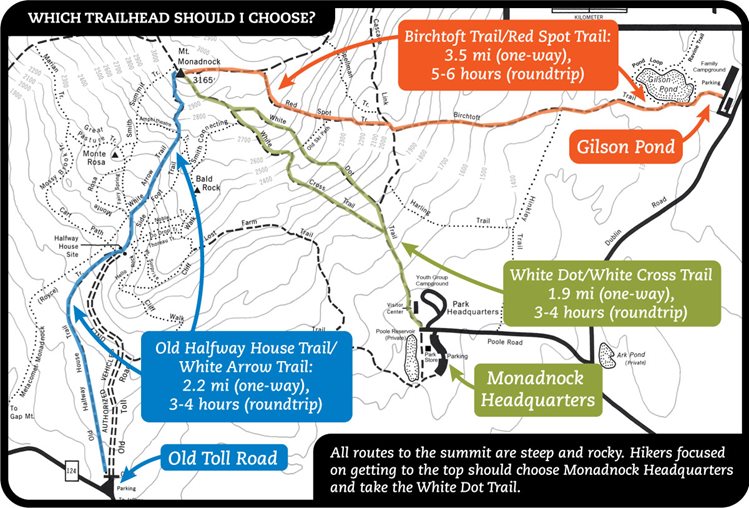
We have listed out some of the trail options up Monadnock below. Take a good look at the above map to help decide the best trail for you to take. You’ll notice that there are several starting locations and several routes from the main starting location at the State Park Headquarters. To help you choose trails, the state park created a helpful image that is below. Recommended routes for beginners are the White Dot/White Cross or the Old Halfway House Trail / White Arrow Trail due to these being the easier options to the summit.
White Dot Trail – 3.8 miles round trip
There are multiple trails that reach the summit Mount Monadnock. The White Dot trail is the most popular route to reach the summit. Begin your hike at the Monadnock State Park Headquarters. About 0.6 miles in, there will be a junction with the White Cross Trail, continue along the White Dot Trail until you reach a “halfway point” sign, indicating you have made it 1/2 of the way to the summit. The trail begins to steepen and become rocky for a bit. The White Dot passes the Smith Connecter at 1.5 mile then joins the White Cross Trail at 1.6 mile. Just past the White Cross junction the White Dot drops back into treeline, and then steeply climbs until reaching the exposed summit of Mount Monadnock. To descend, there is a rock with “to State Park Headquarters” painted on it to show which direction to go. Follow the trail for roughly 1.9 miles until you reach the State Park Headquarters where you started.
White Dot Trail Map

Alternative routes
White Cross Trail
The White Cross is said to be less steep in places than the White Dot. Both trails are very rocky. The White CrossTrail is marked with white cross shaped blazes along the rocky trail. Begin your hike on the White Dot trail roughly 0.6 mile from headquarters. Follow the White Cross Trail, passing by a few springs of water, climbing moderately through the woods on rocky trail. Continue until you reach the Smith Connecter junction at 1.6 mile, then the White Cross joins up with the White Dot Trail until you reach the summit of Mount Monadnock at 1.7 miles. To descend from the summit look for “to State Park Headquarters” painted in rock and follow White Dots down to White Cross junction. It is roughly 2 miles of hiking until you reach the bottom where you began.
Elevation gain: 1,742 feet (530.96 meters)
Distance: 3.8 miles roundtrip (6.12 km)
Duration (book time): 3-4 hours
Difficulty: Moderate

White Arrow Trail
Elevation gain: 1,627 feet (495.91 meters)
Distance: 4.3 miles roundtrip (6.92 km)
Duration (book time): 4 hours
Difficulty: Moderate

Hiking in winter
Mount Monadnock is a mountain that is hiked year-round. Though the summit is below 4,000 feet, genera; precaution should be taken. The trail is very rocky and crampons and/or microspikes will be necessary in icy and snowy conditions. Always be prepared beforehand.
Camping And Overnight Hiking Options
Monadnock State Park has designated camping areas and tent sites within the state park. Call ahead for a reservation. Fees will apply. You can read more about camping options here: https://www.nhstateparks.org/visit/state-parks/monadnock-state-park
Parking
For the White Dot trail, the parking area is on a small side road off Poole Road near the end of Poole Road on the left side. The main entrance to the state park (the trailheads of white spot, white cross, cascade link) is a large parking area. Admission is $3.00 per person over 12 years old.
Directions
To get to the White Dot Trail parking area (Monadnock State Park)
On a GPS, type in the address of 116 Poole Road, Jaffrey, New Hampshire for Monadnock State Park. From Route 124 West Turnpike Road, and then take a sharp right turn onto Dublin Road. Continue on the road for roughly 1.3 miles and turn left onto Poole Road.
Weather Forecast
Troy, NH
Tonight
Mostly clear, with a low around 25. Northwest wind 10 to 15 mph, with gusts as high as 25 mph.
Thursday
Sunny, with a high near 46. Northwest wind 5 to 10 mph.
Thursday Night
Clear, with a low around 27. North wind 5 to 10 mph.
Friday
Sunny, with a high near 54. Northwest wind around 5 mph.
Friday Night
Mostly clear, with a low around 29. South wind 0 to 5 mph.
Saturday
Mostly sunny, with a high near 58.
Saturday Night
A chance of rain showers after 8pm. Mostly cloudy, with a low around 41. Chance of precipitation is 40%.
Additional photos
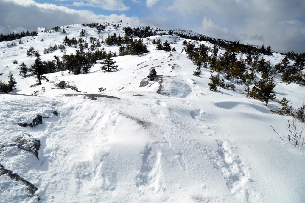
Photo credit – Whit Andrews
Photo credit – Todd Van Hoosear

Andrea is a writer, hiker, and adventurer from New England. She enjoys snowboarding, sunrise hikes, winter, night hiking, traveling, and photography.