Peekaboo slot canyon and spooky gulch are two of the top destinations within Grand Staircase-Escalante National Monument. These two hikes are often combined into one loop, but can also be done separately. Here we will give you everything you need to travel here and hike these incredibly beautiful canyons on your own.
Peekaboo And Spooky Gulch Loop
Here are the quick facts about this loop hike. Other resources say this loop is 3.5 miles, but from the trailhead to the canyon, and doing this full loop, is actually 4.44 miles.
Distance: 4.44 Miles (7.25km)
Elevation Gain: 697 Feet (212.5 meters)
Duration: 3-4 Hours
Difficulty: Intermediate (some scrambling involved)
Peekaboo And Spooky Gulch Trail Map
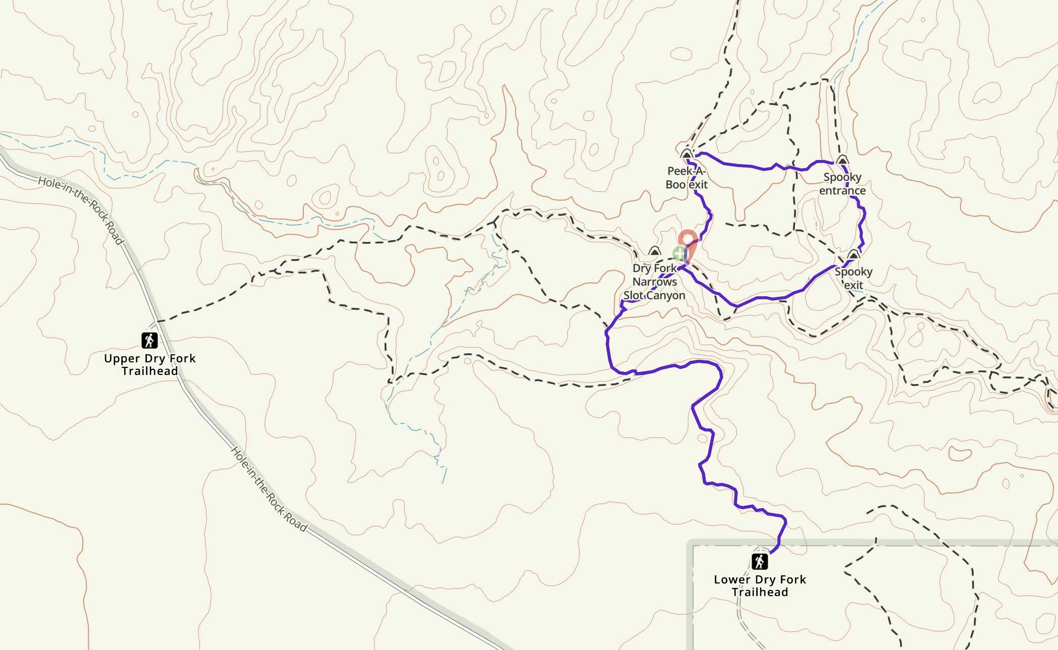
We have highlighted the most common loop here, but you can see the other options and trails on this map.
Need To Know
Before we get into your route options, we wanted to highlight some need to know items.
- The entrance to Peekaboo features a bit of a scramble that can be difficult for those that have never scrambled up anything before.
- Spooky gulch features a section of climbing down that can be difficult for those who are not comfortable holding their own bodyweight. A rope has been added to aid climbers, but ideally, no one has to rely on the rope, and it is just there to add protection and help (a picture of this is below).
- If doing the both canyons, you should go clockwise. Climbing up Peekaboo, and down Spooky Canyon for safety, as well as traffic.
- Dogs should not be on these trails.
- During or shortly after precipitation, these slot canyons can be slippery, or contain water in sections that would make this hike more difficult.
- During or shortly after precipitation, the road leading to the trailhead could get very muddy and difficult for vehicles. We recommend 4WD, however 2WD vehicles can make it to these trailheads without issue during dry times. During wet times, even 4WD vehicles may not make this.
- Only bring a small bag or no bag if needed through the canyons. They get tight, and a backpack just makes it more difficult. Of course, don’t forget to bring the necessary water. Larger individuals can make it through this, but it will be more difficult.
- If you get too nervous about these canyons, don’t fret. You can always have the backup plan of just hiking the Dry Fork Narrows which is located only about 100 yards from the entrance of Peekaboo canyon. Anyone can do this hike, and it is stunning.
Trail Options
There are two parking lots, and a few trails to get to each or both of these canyons, so we wanted to highlight your options here.
Lower Dry Fork Trailhead – 4.44 Miles Round Trip – 697 Feet Elevation Gain
This is our recommended route and parking area for each of these canyons. We have driving directions and parking information below.
This parking area has a bathroom and trail map for hikers to look at. Begin hiking on the well traveled trail and bear left to head along the edge of your cliff and vista views in front of you. Simply follow the well traveled path, and cairns that lead you down into the canyon.
You’ll reach the first junction .97 miles in where you will bear right. 1.14 miles in you’ll reach another junction where you stay to the right and descend into the bottom of the canyon. This is the steepest section of trail on your entire loop, and can be a little slippery if there was recent rain or ice.
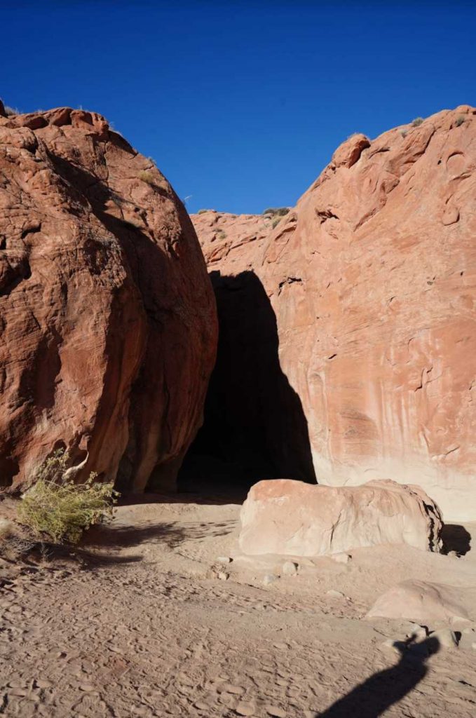
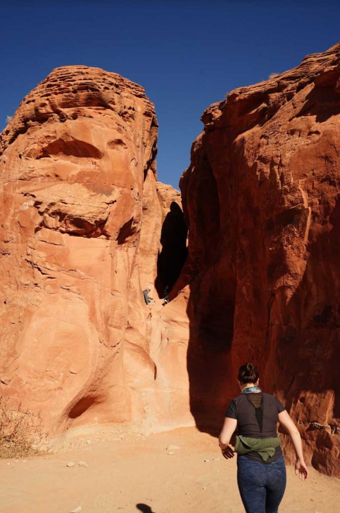
1.38 miles in, hikers will reach a trail sign with a junction to the Dry Fork Narrows (Far left – and a highly recommended hike, straight towards the Peekaboo canyon entrance, and to the right towards Spooky Gulch. This junction can be a little confusing, so check out our pictures below to explain this junction. At this trail sign, you’ll see the entrance of Dry Fork Narrows directly on your left, and across the dried riverbed is the entrance to Peekaboo.
We recommend continuing straight to Peekaboo Canyon entrance (see picture below). The entrance to Peekaboo seems a little daunting standing back from it a bit, but people have carved little footholds and hand holds that make this doable for most individuals, and even younger children (We watched a 6 year old scramble up). We do have to say that if you have little experience, you need to be very cautious here as you can slip, fall, and get seriously injured at the entrance.
The recommended loop is clockwise here to maintain all traffic going in this direction. It is difficult to find spaces to pass individuals within the slot canyons.
Hikers then begin going through the incredibly beautiful canyon and exit Peekaboo canyon 1.79 miles in. Follow the trail by bearing right which connects and brings hikers over to Spooky Canyon’s entrance. 2.22 miles in, hikers will hit the Spooky Canyon entrance.
Here, things get quite tight! It is nice to not have a backpack here, as many sections will require you to take it off of your back to squeeze on through.
.3 miles later, 2.52 miles into the hiker, you’ll exit Spooky Canyon, and you can make your way back to the trailhead, or head on over to Dry Fork Narrows canyon. Simply follow the trail, or the river bed back to the junction.
Upper Dry Fork Trailhead – 4.73 Miles Round Trip – 509 Feet Elevation Gain
We have driving directions and parking information for this trailhead below.
This parking area has a bathroom and trail map for hikers to look at. Begin hiking on the well traveled trail. We recommend staying on the Dry Fork Trail and head through the Dry Fork Narrows. This is a gorgeous section of hike, and you end up popping out of the narrows right next to the Peekaboo Canyon entrance.
If hikers want to do all three canyons, Dry Fork Narrows, Peekaboo Canyon, and Spooky Gulch, this is the recommended starting point.
You can see our map for this route here:
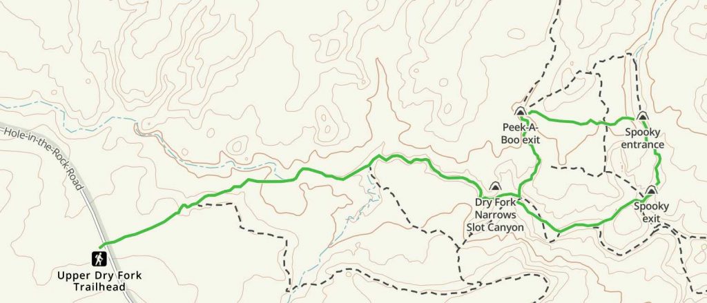
Upper Dry Fork Trailhead Map
Other Routes
Hikers can also choose to hike only Spooky Gulch, or only Peekaboo Canyon. If they do this, they can follow unmarked, but traveled paths from other hikers. We don’t recommend this, but it is certainly an option.
If hikers exit left of Peekaboo canyon, they can loop back around to the entrance via a path from other hikers. If hikers want to avoid, and go down Spooky Gulch only, they can follow those same trails around Peekabook Canyon and head over to the entrance.
In addition, hikers can leave from the Upper Dry Fork Trailhead, and skip the Dry Fork Narrows by taking the other marked and well traveled trails.
Directions & Parking
Both trailheads are located on Hole-In-The-Rock road which is a dirt road that can get muddy during or after precipitation. While we recommend 4WD vehicles, 2WD vehicles can handle this road when it is dry. You’ll be driving 20+ miles on this dirt road. Even 4WD vehicles may not make it when precipitation occurs due to muddy conditions.
Here are the Google Map Locations for each trailhead:
Dry Fork Trailhead (Lower Dry Fork Trailhead):
Upper Dry Fork Trailhead:
Additional Pictures
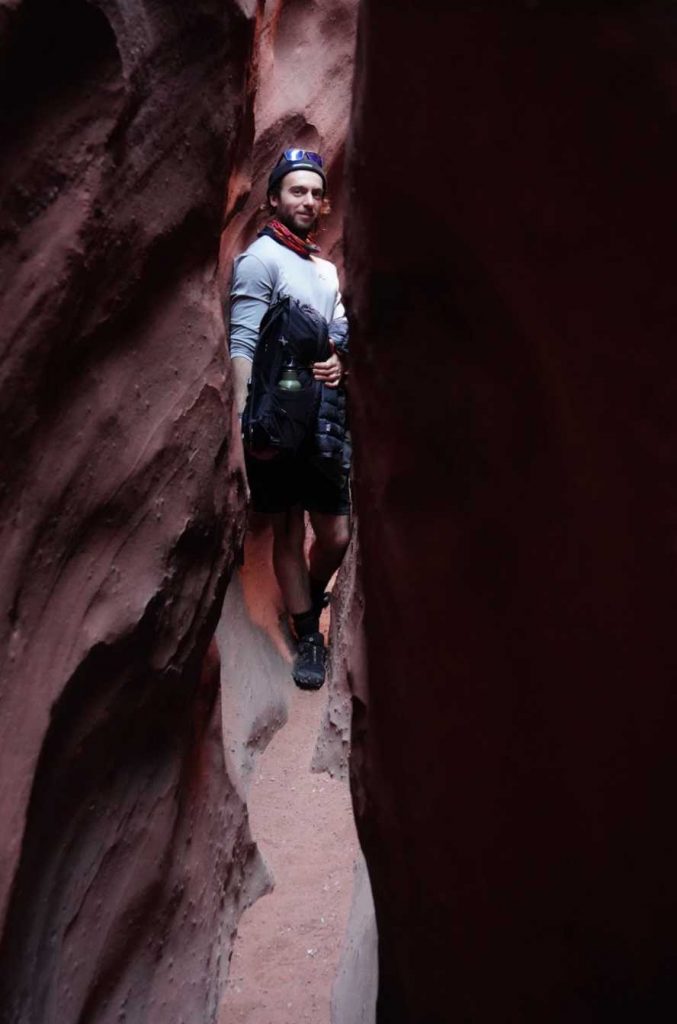
Narrow Slot Canyons of Peekaboo Canyon
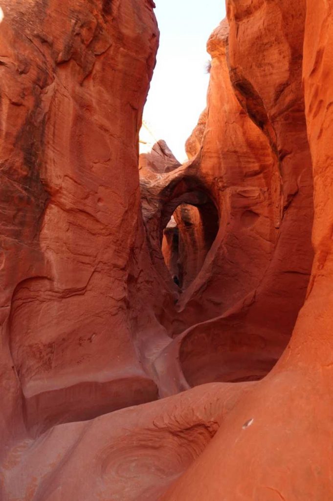
Peekaboo Canyon views
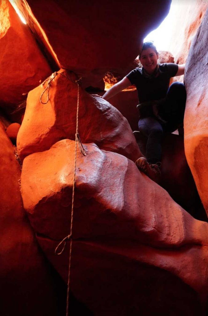
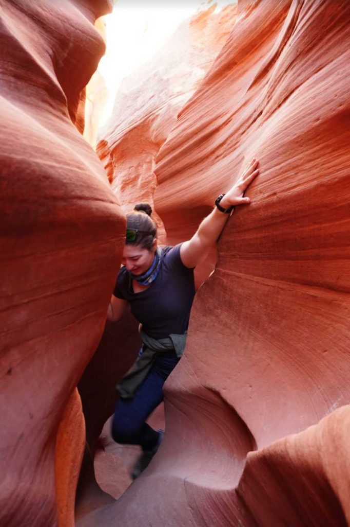
This is the section in Spooky Gulch where hikers need to climb down only a few feet below. A rope hangs for safety with hand and footholds.
This is the entrance to the dry fork narrows as seen from the junction between dry fork narrows and Peekaboo Canyon
This is what the entrance to Peekaboo Canyon looks like
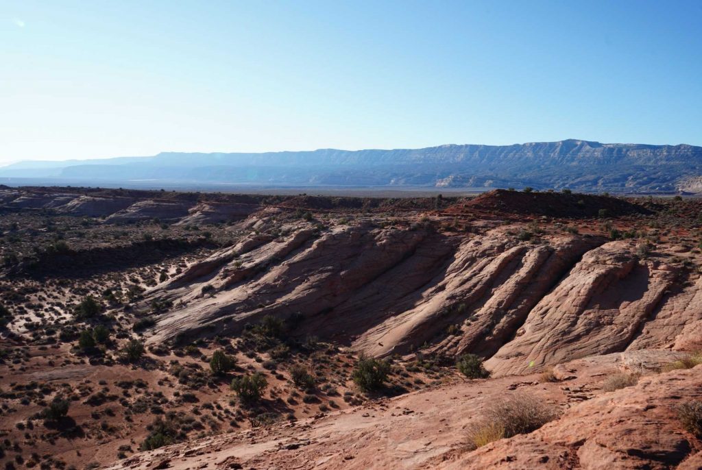
Looking back at the dry fork trailhead only a short distance into the hike.
Narrow Sections of Spooky Gulch

Max DesMarais is the founder of hikingandfishing.com. He has a passion for the outdoors and making outdoor education and adventure more accessible. Max is a published author for various outdoor adventure, travel, and marketing websites. He is an experienced hiker, backpacker, fly fisherman, backcountry skier, trail runner, and spends his free time in the outdoors. These adventures allow him to test gear, learn new skills, and experience new places so that he can educate others. Max grew up hiking all around New Hampshire and New England. He became obsessed with the New Hampshire mountains, and the NH 48, where he guided hikes and trail runs in the White Mountains. Since moving out west, Max has continued climbed all of the Colorado 14ers, is always testing gear, learning skills, gaining experience, and building his endurance for outdoor sports. You can read more about his experience here: hikingandfishing/about
Can't Get Over How Fun This Trail Is
This trail is outrageously fun. Can be a bit hard to find the entrance since it isn’t marked, so take note of the pictures on this page!