Weeping Rock is a hiking trail located in Washington County, Utah, and is within Zion National Park. The trail begins at 4,374′, and is an easy 0.4 mile round-trip hike, making it the shortest in the entire park. The trail is well traveled due to its beauty, location and short distance.
Distance – 0.4 miles roundtrip (.64 km)
Duration (book time) – 30 minutes or less
Difficulty rating – Easy family hike
Trailhead (The Starting Location) – Weeping Rock Trailhead
Seasons – This trail can be accessed year-round by car. There is a hiker shuttle service that operates seasonally via the Zion shuttle stop located at the Zion National Park Visitor Center.
Bathrooms – Primitive restrooms are available to use in the Weeping Rock Trailhead parking lot.
The Trail
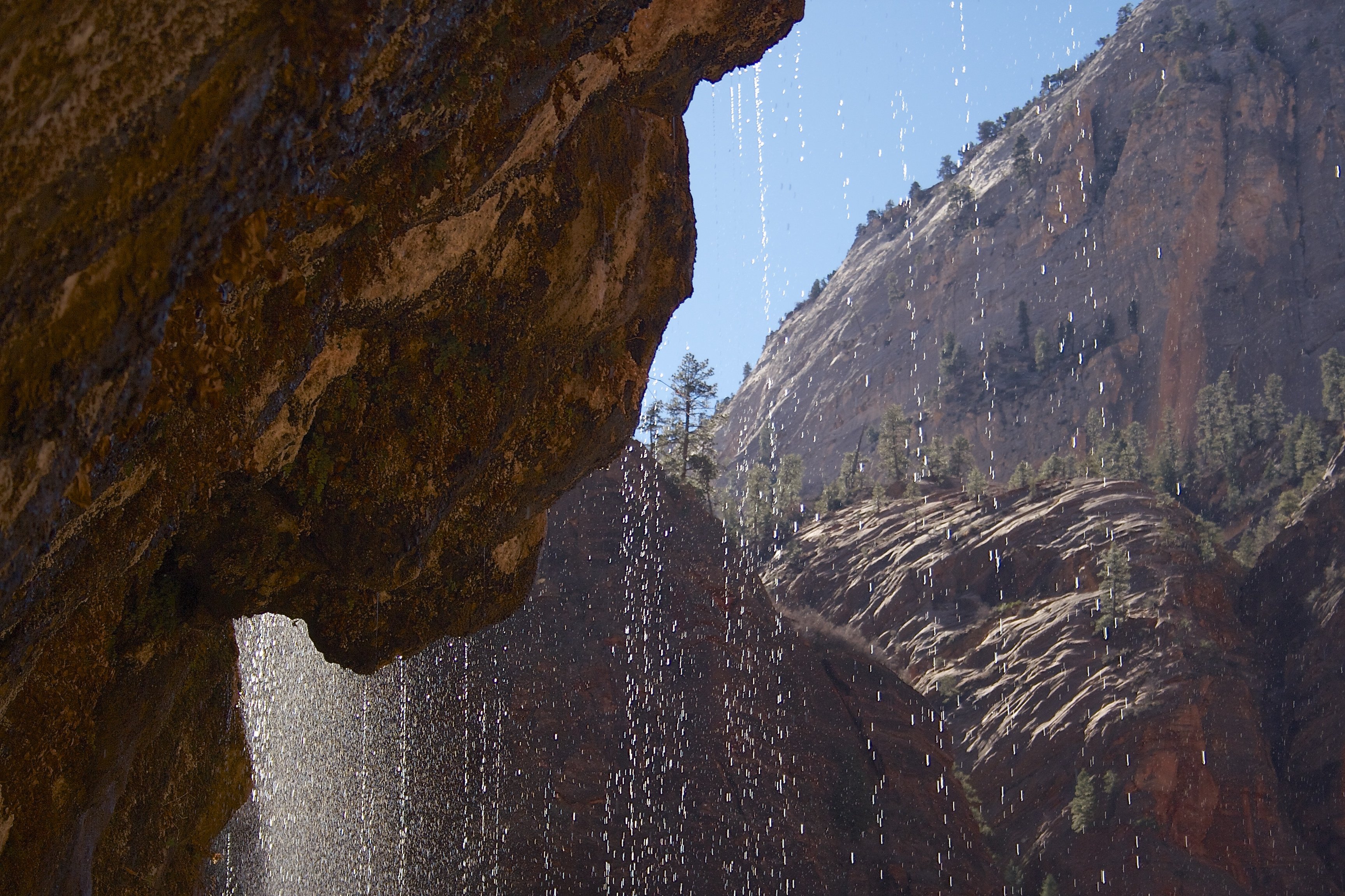
The short, leisurely stroll to Weeping Rock is a 10-minute family-friendly walk. Starting at the Weeping Rock Trailhead, which is the 7th stop on the Zion Canyon Shuttle, walk up the parking lot and across the hiker’s bridge, then make a left turn to hike up the paved trail to the viewing platform. The deck stands under the beautiful alcove with wander sprinkling from above. The trail is well traveled due to its beauty and easy access.
Trail Map

Where does the “weeping” come from?
A continuous flow of water “weeps” out of the Weeping Rock alcove, keeping lush hanging gardens moist. The weeping that comes from above is where Echo Canyon is located, one of the many parks many slot canyons. Parts of Echo Canyon can be viewed along the shared path of the Observation Point and East Rim Trails. The water has been in the rocks for roughly 1200 years.
Hike Features
The lush hanging gardens stay wet and beautiful year round due to constant water flow from the upper canyons. The view of Great White Throne to the left under the water flow is absolutely incredible.
Parking
Begin your hike at the Weeping Rock trailhead parking lot before crossing over the stream along the footbridge. The trailhead bears left, opposite Hidden Canyon, East Rim and Observation Point Trailheads. To begin walk the footpath crossing over a drainage stream that is lined with cottonwood, ash and maple trees.
Directions
Getting to Zion National Park:
From the North: Travel I-15 south, past Beaver. exit on Hwy 20. Follow US-89 to Mount Carmel Junction. Take SR-9 to Zion’s east entrance.
From the South: Travel I-15 north. Take exit 16 and travel through Hurricane to LaVerkin. Continue on SR-9 to the south entrance of the park. SR-9 through the Zion-Mt. Carmel Highway.
Nearby hikes
For those looking for a longer and more challenging adventure, there’s plenty of other trails nearby to extend your hiking day. Be sure to check out Observation Point, and Cable Mountain in the area!
Before You Go
Keep in mind that summer is the busiest season to visit while Spring and Fall provide the most water flow.
* NOTE * While the trail is paved, it is not wheelchair friendly because the trail is fairly steep near the end.
Visiting in winter: Sections of the trail may be closed temporarily in winter due to falling ice and snow hazards.
Current Weather Conditions
Springdale, UT
Tonight
Mostly clear. Low around 51, with temperatures rising to around 53 overnight. Northwest wind around 6 mph.
Thursday
Mostly sunny, with a high near 78. West northwest wind 3 to 10 mph.
Thursday Night
Partly cloudy, with a low around 54. South southwest wind 3 to 10 mph.
Friday
Sunny, with a high near 79. South southeast wind 6 to 10 mph.
Friday Night
Partly cloudy, with a low around 53. North northwest wind 6 to 10 mph.
Saturday
Sunny, with a high near 79.
Saturday Night
Mostly clear, with a low around 55.
Additional Photos

Andrea is a writer, hiker, and adventurer from New England. She enjoys snowboarding, sunrise hikes, winter, night hiking, traveling, and photography.
-
Beauty
-
Parking
-
Trail Conditions