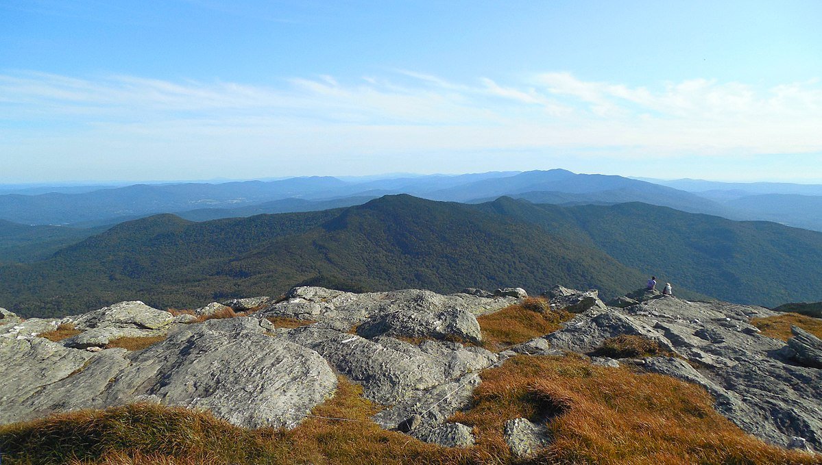
Camel’s Hump is located in the Green Mountains of Vermont. It is the third highest peak in the entire state, standing at 4,083 feet in elevation.
Elevation: 4,083 feet (1244.50 m)
Elevation gain: 2,349 feet (715.98 m)
Distance: 4.8 miles roundtrip (7.72 km)
Duration (book time): 3 hours
Difficulty: Moderate
Trails
Burrows Trail – 4.8 miles round trip
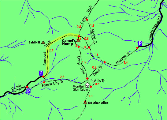
Begin hiking on the Burrows Trail from the parking area for roughly 2.1 miles. You will then reach a junction for the Long Trail. At the sign, turn right and continue along the Long Trail for another 0.3 miles until you reach the summit of Camel’s Hump. After soaking in the views, begin your descent by following the Long Trail back to the junction. Retrace your steps until you reach the trailhead parking lot where you began.
Trail Map

Alternate routes
Monroe Trail
The Monroe Trail is rather steep, and less popular than the Burrows Trail. To begin your hike on the Monroe Trail, continue along until reaching an intersection with the Dean Trail. At the junction, it gives you the option to turn left onto Dean Trail and then take the Long Trail up to the summit or continue straight on the Monroe Trail to reach the summit. If you choose to continue on the Monroe Trail, you will reach the hut clearing area, where the Monroe Trail ends and becomes the Long Trail. The climb to the summit of Camel’s Hump is not far from here. After reaching the summit and soaking in the views, start your descent by retracing your steps the way you came from.
Elevation gain: 2,578 feet
Distance: 6 miles roundtrip
Duration (book time): 4 hours
Difficulty: Strenuous
Hiking in Winter
Camel’s Hump is often climbed via the Burrows Trail and Monroe Trail during the winter. The Monroe Trail requires a road walk from the winter parking area to access the start of the trail. The Burrows Trail parking lot is usually plowed.
Camping and Overnight Hiking Options
The Montclair Glen Lodge and the Hump Brook campsite are available for hikers looking for camping and lodging in the immediate area. Fees and reservations may apply.
Parking
The parking area for the Burrows Trail is located on Camels Hump Road in Huntington, Vermont.
Directions
To get to the Burrow Trail parking area
From I-89 North, take exit 10 for VT-100 South towards Waturbury/US-2. Drive 0.3 miles and turn left onto VT-100 South. Drive another 0.5 miles and turn right onto US-2 W/N Main Street. Continue on US-2 West for 9.6 miles. Take a left onto Cochran Road and drive 0.3 miles and turn left onto Wes White Hill. Drive for roughly 3.1 miles and continue on Pond Road. Drive 1.4 miles and continue on Bridge Street. Drive 0.6 miles and turn left onto East Street. Take a slight right turn onto Main Road and continue for 2.5 miles. After 2.5 miles, turn left onto Camels Hump Road. Drive 0.6 miles and stay to the right onto Camels Hump Road. Drive to the very end of the road going past the gate. If the gate is closed, park in the Winter lot right before it.
To get to the Monroe Trail parking area
From I-89 off of Exit 10. Take Route 2-100 south to the town of Waterbury. Stay on the road until you cross over a bridge. Once over the bridge, turn right on Route 100, and another sharp right turn onto Main Street. Follow Main Street until you reach a T intersect with River Road. Stay straight onto River Road, which is a dirt road, all the way to Camel’s Hump Road. Take a left turn to reach the Monroe trailhead 0.4 miles from the intersection.
Weather
The summit of Camel’s Hump is exposed to the elements, so pack and plan accordingly. Here is a detailed four day forecast:
Waterbury, VT
Today
A slight chance of rain showers. Mostly cloudy, with a high near 51. West wind around 7 mph. Chance of precipitation is 20%.
Tonight
Rain showers likely. Mostly cloudy, with a low around 46. Southwest wind 5 to 18 mph. Chance of precipitation is 60%. New rainfall amounts less than a tenth of an inch possible.
Thursday
A chance of rain showers. Mostly cloudy, with a high near 56. West wind 15 to 23 mph. Chance of precipitation is 50%. New rainfall amounts between a tenth and quarter of an inch possible.
Thursday Night
A slight chance of rain showers before 8pm. Mostly cloudy, with a low around 42. North wind 6 to 15 mph. New rainfall amounts less than a tenth of an inch possible.
Friday
Partly sunny, with a high near 57. East wind around 7 mph.
Friday Night
A slight chance of rain showers after 2am. Mostly cloudy, with a low around 45. Southeast wind 6 to 12 mph.
Saturday
A chance of rain showers. Mostly cloudy, with a high near 54. South wind 10 to 15 mph. Chance of precipitation is 30%.
Additional Photos

Photo credit – Wikipedia

