Capitol Peak is a 14,130 foot mountain in the Elk Range of Colorado most well known for its difficult and dangerous ridge and knife edge of class 4 hiking. Below we will cover each of the trail options, information about camping, roads, trail maps and more to help you stand atop this Colorado 14er. This hike features tons of camping options, incredible views, huge cliffs, and dangerous sections.
Distance – 16.6 miles round trip (26.72 km)
Height – 14,130 feet (4306.824 m)
Elevation gain – 5,770 feet (1758.7 m)
Duration – 9 to 12 hours (book time)
Difficulty – Strenuous
Class: Class 4 Hike
Seasons – This hike should not be attempted in winter unless you have lots of winter climbing experience.
Trailhead Location – Capitol Creek Trailhead – 9,460 feet (directions below)
Trails
Capitol Creek Trailhead (2WD & 4WD trailhead): Via Capitol Creek Trail 16.6 Miles Round Trip | 5,770 Feet Elevation Gain | Class 4
This is the traditional route up Capitol Peak. Helmets should be worn for all routes to the summit. Hikers begin by descending around 420 feet to Capitol Creek before beginning a long and gradual walk in towards Capitol Lake. 3 miles in, hikers will reach a junction for the West Snowmass Trail. HIkers should continue straight here. 3.4 miles from this junction, hikers will reach Capitol Lake. Just before the lake, there are various tent sites that are a great option for those that want to turn this into an overnight hike.
All the way to Capitol Lake, the trail is very easy to follow.
Just before Capitol Lake, the trail bears left up towards the ridge. Hikers quickly ascend the ridge via switchbacks.
From the ridge, hikers have the choice of following the main trail, which involves descending down the ridge towards the main trail (recommended – see image below), or staying atop the ridge and traveling directly towards K2 and Capitol. Unless you have lots of climbing experience, we strongly suggest descending down and following the main trail.
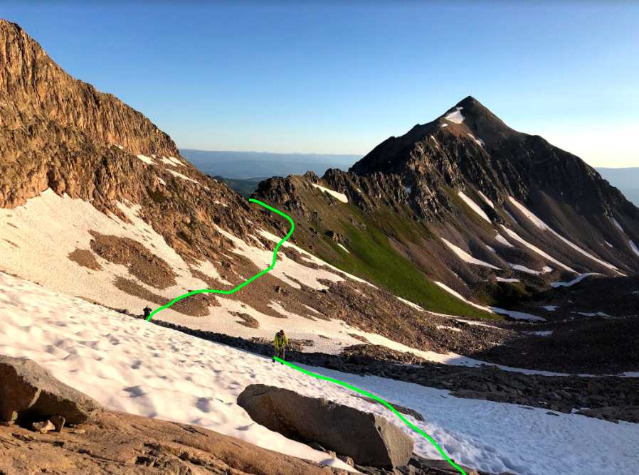
Hikers will then ascend through this area up towards the east side of K2. The trail is relatively easy to follow from here, but you will find it snow covered much of the year. Hikers should ascend all the way to the ridge before K2 here.
Summiting K2
The common path travels slightly around the summit of k2. Our recommendation is to go right over the top of K2 and descending down slightly around it. In our experience, if choosing the right path here, it is simpler, safer, easier, and also allows you to stand atop this very cool summit. This is especially the case when any snow is present.
Hikers need to simply take their time choosing the right path over the top of K2 and descending to the northwest side of the summit then towards the saddle between k2 and Capitol. From here, the path is relatively simple towards the knife edge.
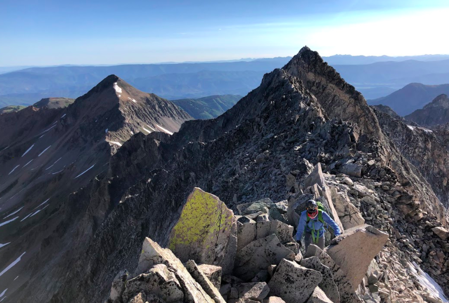
The Knife Edge
This is the most famous section of Capitol Peak. While it is dangerous, and features pretty steep drops on either side of the edge, hikers have the ability to crawl or straddle the edge if uncomfortable. As long as hikers take it slow and are cautious, this section is not that bad. If you have a fear of heights, this hike will be scary.
Beyond the knife edge, hikers will find cairns along the way that mark the path towards the summit. Continue following these cairns as generally these cairns mark the easiest path through a lot of loose rocks and steep terrain. Be extremely careful of loose and falling rocks during the entire section after K2 and towards the summit.
Capitol Creek Trailhead (2WD & 4WD trailhead): Via Ditch Trail 16.2 Miles Round Trip | 5,570 Feet Elevation Gain | Class 4
This route is nearly the same as above. Hikers start at the same parking lot, the trailhead just starts a little farther into the parking lot and has a sign marked as the ditch trail. This route is becoming more popular than the traditional route because it saves hikers around 350 feet of elevation gain and loss by staying above Capitol Creek. It meets back up with the main route 3.2 miles into the hike. From there on, it is the same route as described above.
Trail Map
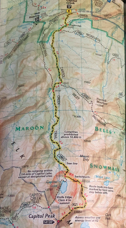
Capitol Peak Trail Map
Hiking Capitol Peak in Winter
Capitol Peak is one of those mountains that shouldn’t be attempted in winter unless you have a lot of experience climbing winter peaks. The danger of this mountain in winter months is substantial.
Camping For Capitol Peak
There are dispersed campsites along the road leading to the trailhead for Capitol Peak. Many also choose to camp near the trailhead where there are various tent sites. There are no official campgrounds nearby though.
Another option is to camp after hiking in a ways. There are various dispersed camping areas on within the first 3 miles, but most will camp just before reaching Capitol Lake as this is a stunningly beautiful area with many dispersed campsites.
Current weather conditions:
Here is the detailed weather forecast for the next few days. We highly recommend you check out the mountain forecast for this peak the morning of your hike.
Marble, CO
This Afternoon
Snow showers likely and a slight chance of thunderstorms. Partly sunny, with a high near 30. West southwest wind 15 to 20 mph. Chance of precipitation is 60%. New snow accumulation of less than half an inch possible.
Tonight
Snow showers likely and a slight chance of thunderstorms. Cloudy, with a low around 18. West wind 15 to 25 mph. Chance of precipitation is 60%. New snow accumulation of 2 to 4 inches possible.
Friday
Snow showers before noon, then snow showers and a chance of thunderstorms. Cloudy, with a high near 24. West southwest wind 20 to 25 mph. Chance of precipitation is 90%. New snow accumulation of 1 to 3 inches possible.
Friday Night
Snow showers and a chance of thunderstorms. Cloudy, with a low around 18. Southwest wind 10 to 25 mph. Chance of precipitation is 90%. New snow accumulation of 2 to 4 inches possible.
Saturday
Snow showers before 9am, then snow showers and a chance of thunderstorms. Cloudy, with a high near 20. West southwest wind 10 to 15 mph. Chance of precipitation is 100%. New snow accumulation of 4 to 8 inches possible.
Saturday Night
Snow showers and a chance of thunderstorms. Cloudy, with a low around 18. Chance of precipitation is 90%. New snow accumulation of 1 to 3 inches possible.
Sunday
Snow showers and a chance of thunderstorms. Cloudy, with a high near 23. Chance of precipitation is 90%. New snow accumulation of 1 to 3 inches possible.
Directions & Parking
The road leading to the trailhead is great up until the last mile or so. Any high clearance vehicle should have no problem with this road. Some portions of the road should be driven cautiously with 2wd or low clearance vehicles.
Directions to Capitol Creek Trailhead
Additional Pictures
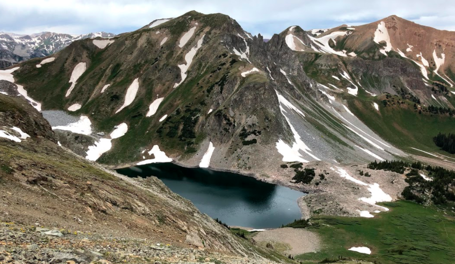
Capitol Lake
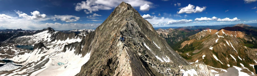
The Knife Edge – Capitol Peak
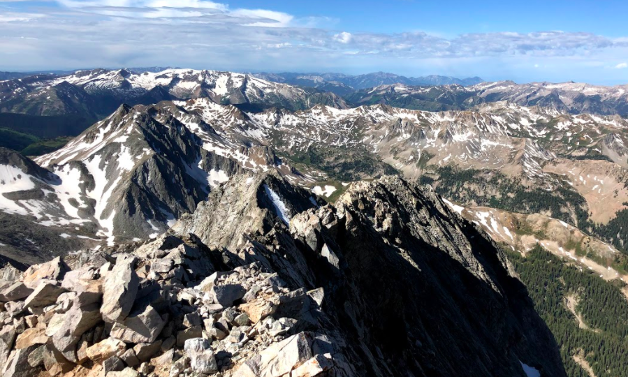
Views from Capitol Summit
Views of Capitol Lake From Capitol Summit
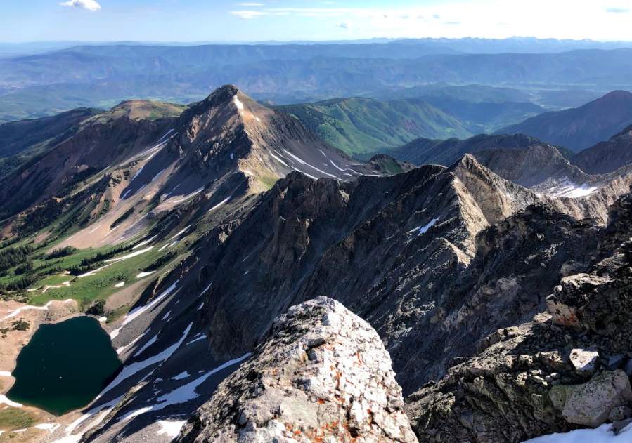
Views of K2 (right) and Mount Daly (left) from Knife Edge
Views of Route after K2 on Mount Daly Saddle

Max DesMarais is the founder of hikingandfishing.com. He has a passion for the outdoors and making outdoor education and adventure more accessible. Max is a published author for various outdoor adventure, travel, and marketing websites. He is an experienced hiker, backpacker, fly fisherman, backcountry skier, trail runner, and spends his free time in the outdoors. These adventures allow him to test gear, learn new skills, and experience new places so that he can educate others. Max grew up hiking all around New Hampshire and New England. He became obsessed with the New Hampshire mountains, and the NH 48, where he guided hikes and trail runs in the White Mountains. Since moving out west, Max has continued climbed all of the Colorado 14ers, is always testing gear, learning skills, gaining experience, and building his endurance for outdoor sports. You can read more about his experience here: hikingandfishing/about