Distance – 5.4 miles round trip (8.69 km)
Height – 14,048 feet (4,281.8 m)
Elevation gain – 2,555 feet (778.76 meters)
Duration – 5 – 7 hours (book time dependant upon trailhead start)
Difficulty – Strenuous
Class: Class 2 Hike
Seasons – This hike can be completed in all seasons, but winter is especially difficult, and dangerous. Roads to trailheads close in winter.
Trailhead Location – American Basin Trailhead (11,600 Feet) | Silver Creek / Grizzly Gulch Trailhead (10,420 Feet)
Quick Navigation:
Routes | Trail Map | Camping Info | Weather | Directions | Pictures
Need To Know Information
-
- Dogs are allowed on this hike.
- Camping is allowed at the trailhead.
- The road to the trailhead is rough, but accessible for 4wd vehicles at American Basin, or high clearance 2WD at Silver Creek / Grizzly Gulch.
- The road to the trailheads close in winter.
Hiking Route Options
American Basin Trailhead | Standard Route – 5.4 Miles Round Trip – 2,555 Feet Elevation Gain (778.764 meters)
This is the standard route up Handies and the easiest route to the summit. The basin is incredibly beautiful and so is the drive. Dispersed camping is available along the road in several different areas. Driving and road information is located below.
The trail begins and hikers travel with a gradual gain upwards into the basin. The trail is very well traveled and easy to follow.
1.6 miles in, hikers will reach a small spur trail to Sloan Lake which sits a little below 13,000 feet.
From here, the hike begins to climb up to the ridge with a series of easily traveled switchbacks. Once hikers reach the ridge, they are rewarded with incredible views, and a clear view of the the trail heading up loose dirt and some scree to the summit.
Silver Creek / Grizzly Gulch – 7.74 Miles (12.46 km) – 3,753 Feet (1143.91 M) Elevation Gain
This route starts from the Silver Creek / Grizzly Gulch Trailhead at 10,420 feet and follows an almost perfectly gradual gain to the summit of Handies. Hikers ascend the north ridge via this route with beautiful views of the Silver Creek valley, and the route features meadows, and great views of Handies Peak.
Grizzly Gulch & American Basin Loop – 10 Miles (16.09 km) – 4,051 Feet (1234.75 m ) Elevation Gain
A great loop to experience the entire scenic trip would be to leave from Grizzly Gulch trailhead, hike to the summit, continue down into American Basin, and hike the road all the way back out to your starting point. This is a 10 mile loop and an amazing option to experience both of the stunning routes to Handies Peak.
Trail Map
Standard Route In Yellow, Grizzly Gulch / Silver Creek Route In Red
Camping For Handies Peak
Hikers most frequently stay in the town of South Fork, but the road leading to the trailhead contains campgrounds, like Mills Creek Campground, and various places to camp. There are various dispersed campsites off the side of the road heading towards American Basin. Be sure to avoid any of the marked private lands. The Grizzly Gulch / Silver Creek trailhead also has some established tent sites.
Current Weather Conditions:
Here is the detailed weather forecast for the next few days. We highly recommend you check out the mountain forecast for this peak the morning of your hike.
Silverton, CO
This Afternoon
Snow showers and a chance of thunderstorms. Mostly cloudy, with a high near 27. Southwest wind around 20 mph, with gusts as high as 35 mph. Chance of precipitation is 80%. New snow accumulation of 1 to 2 inches possible.
Tonight
Snow showers and a chance of thunderstorms. Cloudy, with a low around 15. South southwest wind 15 to 20 mph, with gusts as high as 35 mph. Chance of precipitation is 90%. New snow accumulation of 2 to 4 inches possible.
Saturday
Snow showers before 9am, then snow showers and a chance of thunderstorms. Cloudy, with a high near 21. West southwest wind 10 to 15 mph. Chance of precipitation is 90%. New snow accumulation of 3 to 5 inches possible.
Saturday Night
Snow showers likely and a chance of thunderstorms. Cloudy, with a low around 18. West northwest wind around 15 mph. Chance of precipitation is 70%. New snow accumulation of 3 to 5 inches possible.
Sunday
Snow showers likely before noon, then snow showers and a chance of thunderstorms. Mostly cloudy, with a high near 25. West northwest wind around 15 mph. Chance of precipitation is 90%. New snow accumulation of 1 to 3 inches possible.
Sunday Night
A slight chance of snow showers and a slight chance of thunderstorms before midnight. Partly cloudy, with a low around 13. Chance of precipitation is 20%. Little or no snow accumulation expected.
Monday
Sunny, with a high near 31.
Directions & Parking
2WD vehicles can make it to the Silver Creek / Grizzly Gulch. The standard trailhead requires a 4WD vehicle with some good clearance. A small stream crossing is necessary to get to the American Basin trailhead. This is achievable for 4WD vehicles in most conditions. In spring, it can be pretty deep, and hikers can find parking spots before the stream crossing if they feel uncomfortable crossing. This adds about 1 mile each way.
The below Google pins are correct, though there are reports that Google and Apple may not have perfect directions along the dirt roads. Be sure to study the map and follow these directions:
From Lake City, Take Highway 149 south for 2.5 miles and turn right on County Road 30 (Lake San Cristobal Road) toward Lake San Cristobal. Follow the paved road that turns to dirt about 4.0 miles in, then continue for 12.6 miles. Look for a sign on the left (south) side of the road for Handies Peak. At the left turn, this is where most 2WD vehicles will park. Find open parking space along the side of the road.
These directions will take you directly passed the Grizzly Gulch trailhead which is clearly marked and has a good sized parking area along with bathrooms.
Directions to American Basin Trailhead:
Directions to Silver Creek / Grizzly Gulch Trailhead:
Additional Pictures
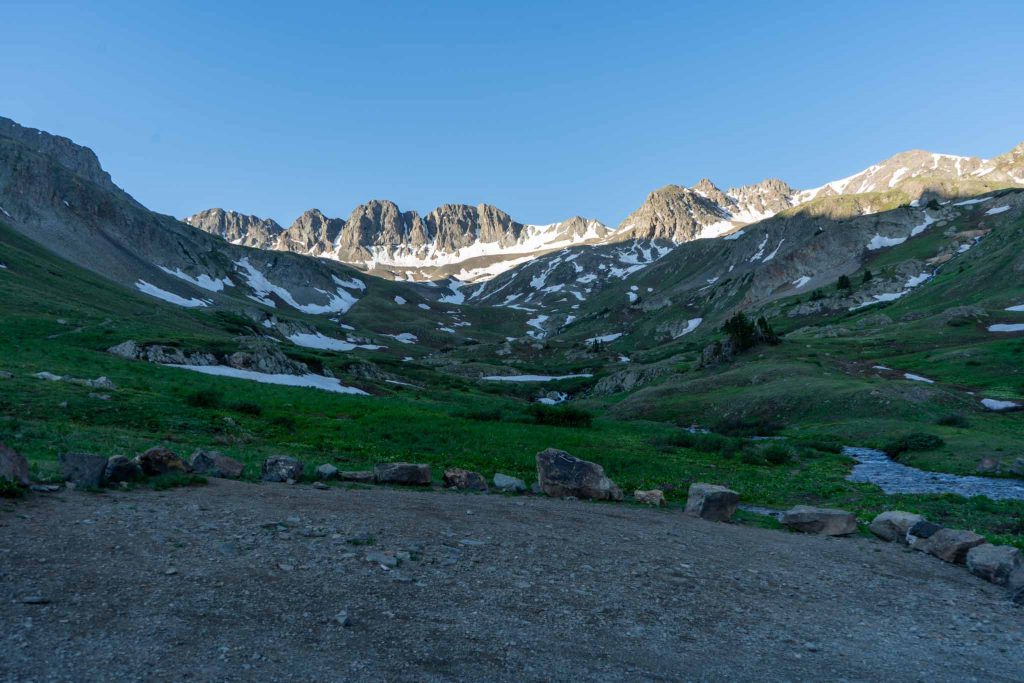
Views Of American Basin
American Basin, Colorado
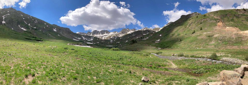
Views From Handies Peak Summit
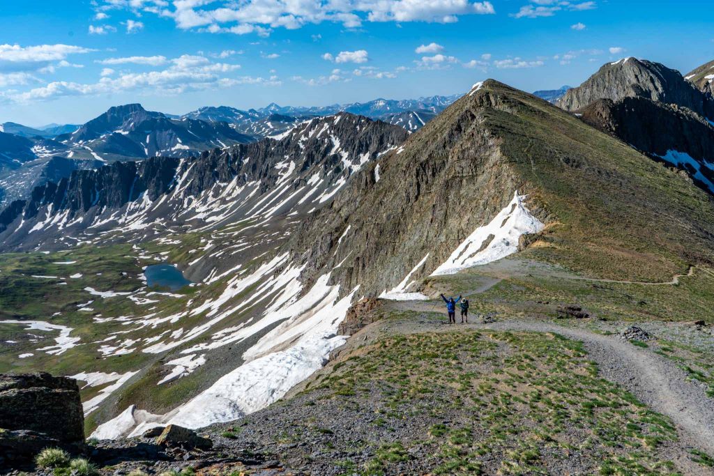
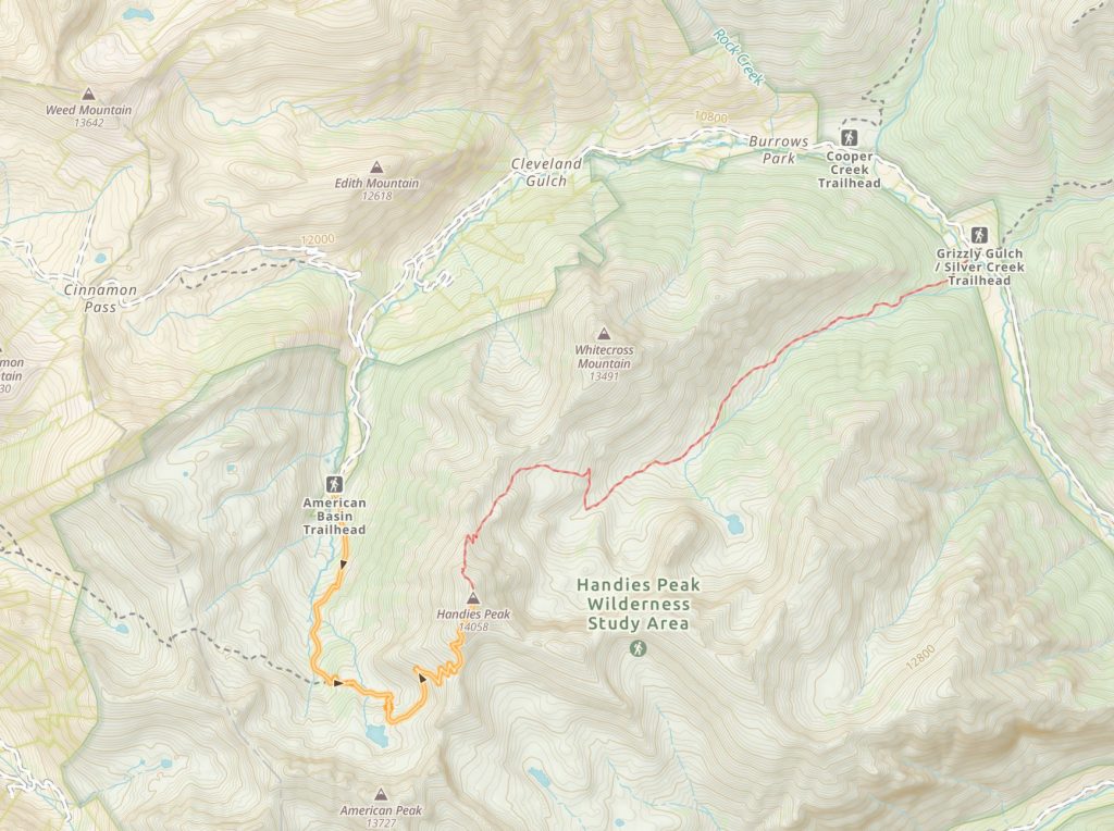
Gaining the ridge before Handies Peak summit
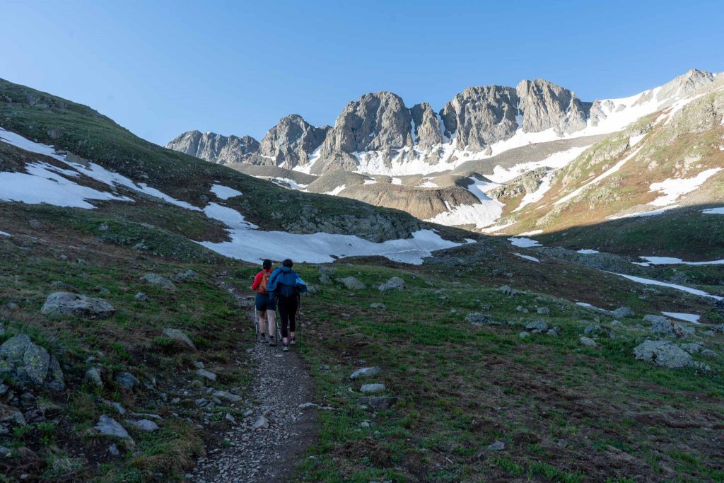
Approaching Sloan Lake
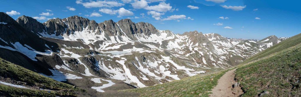
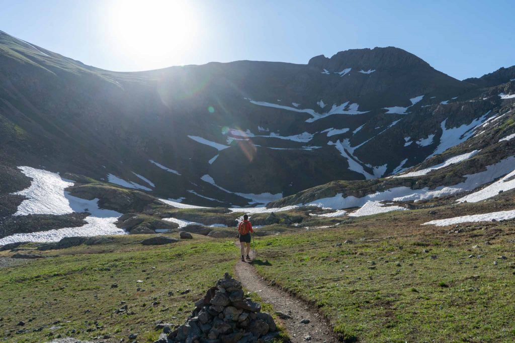
Early trail views in American Basin
American Basin Trailhead

Grizzly Gulch / Silver Creek Trailhead

Max DesMarais is the founder of hikingandfishing.com. He has a passion for the outdoors and making outdoor education and adventure more accessible. Max is a published author for various outdoor adventure, travel, and marketing websites. He is an experienced hiker, backpacker, fly fisherman, backcountry skier, trail runner, and spends his free time in the outdoors. These adventures allow him to test gear, learn new skills, and experience new places so that he can educate others. Max grew up hiking all around New Hampshire and New England. He became obsessed with the New Hampshire mountains, and the NH 48, where he guided hikes and trail runs in the White Mountains. Since moving out west, Max has continued climbed all of the Colorado 14ers, is always testing gear, learning skills, gaining experience, and building his endurance for outdoor sports. You can read more about his experience here: hikingandfishing/about