The majestic Lone Peak. Standing tall as the crown jewel of the Wasatch Range, this iconic summit beckons hikers with its awe-inspiring cliffs, views, and difficult trail. Here’s everything you need to know
Distance – 15.2 miles round trip (24.5 km)
Height –11,260 feet (3,430 m)
Elevation gain – 6,029 feet (1837.6 meters)
Duration – 10-11 hours
Difficulty – Difficult
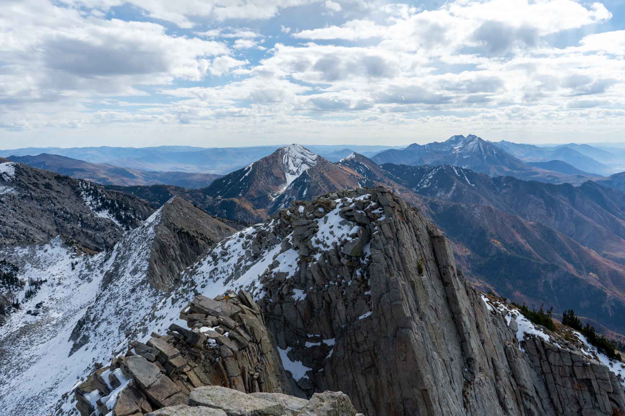
Hike Class: Class 4 hiking
Trailhead Locations – Peak View Trailhead | Jacob’s Ladder / Ghost Falls Trailhead | Orson Park and Trailhead (Directions Below)
Quick Navigation:
Routes | Trail Map | Lodging Info | Weather | Directions | Pictures
Need To Know Information
-
-
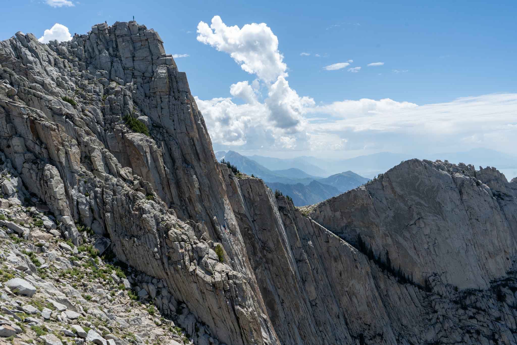
- Lone Peak from any trailhead has lots of elevation gain, lots of miles, and exposed class 4 scrambling to summit. It therefore should not be taken lightly. Hikers and groups without class 3 scrambling experience will find the last portion of this hike to be scary and difficult.
- Lone Peak sits in the Lone Peak Wilderness, which has some regulations to consider. Know how to poop in the woods via carry in and carry out methods.
- This is often turned into an overnight hike as dispersed camping is common in the basin below the summit.
- There are various trailheads to start from for this peak, and we will cover the recommended options below.
-
Hiking Route Options
There are various route options, all of which are strenuous. Here is the information associated with each.
Lone Peak Via Peak View Trailhead | 15.2 Miles Round Trip (24.5 km) – 6,029 Feet Elevation Gain (1837.6 meters)
This is our recommended trailhead for most people due to the large parking area, the accessibility for any vehicle, and a well maintained trail to follow just about the entire way. It involves making the correct turns, particularly near the trailhead around many biking and hiking trails.
This option is one of the longer mileage options, but is the second shortest option in terms of elevation gain.
We have created a full GPX file and map of this route for you: Peak View Trailhead Map & GPX File
Lone Peak Via Jacob’s Ladder / Ghost Falls Trailhead | 14.0 Miles Round Trip (22.5 km) – 5,964 Feet Elevation Gain (1817.8 meters)
This is our recommended trailhead for those with high clearance vehicles that are willing to drive on a dirt road for a slightly shorter option. It is commonly called Jacob’s Ladder Trailhead, but is also called the Ghost Falls Trailhead.
This option is the quickest option for most given the mileage and elevation gain. This trailhead requires driving on a dirt road for a couple miles.
We have created a full GPX file and map of this route for you: Jacob’s Ladder / Ghost Falls Trailhead Map & GPX File
Lone Peak Via Bear Canyon / Orson Smith Park and Trailhead | 14.6 Miles Round Trip (23.5 km) – 7,116 Feet Elevation Gain (2169.0 meters)
This is not the recommended trailhead for the first time given its extremely significant elevation gain of above 7,000 feet.
This is a stunning and gorgeous option for many however, and if you are up for the extra vertical gain, go for it!
We have created a full GPX file and map of this route for you: Bear Canyon / Orson Smith Park and Trail Trailhead Map & GPX File
Other Lone Peak Options
The above three options are just the most common starting points. There are various trailheads that hikers can start from. Most of those meet up with the trails discussed in the above options at various points. You are welcome to hike from those other spots, just do a little bit of research before you do so, and consult a map to make sure you know your way.
Hiking Lone Peak In Winter
This hike is not hiked frequently in winter due to avalanche danger, and lots of steep cliffs and drop offs that can be deadly with a fall. Do not attempt to summit without the proper equipment, experience, and knowledge.
Trail Map
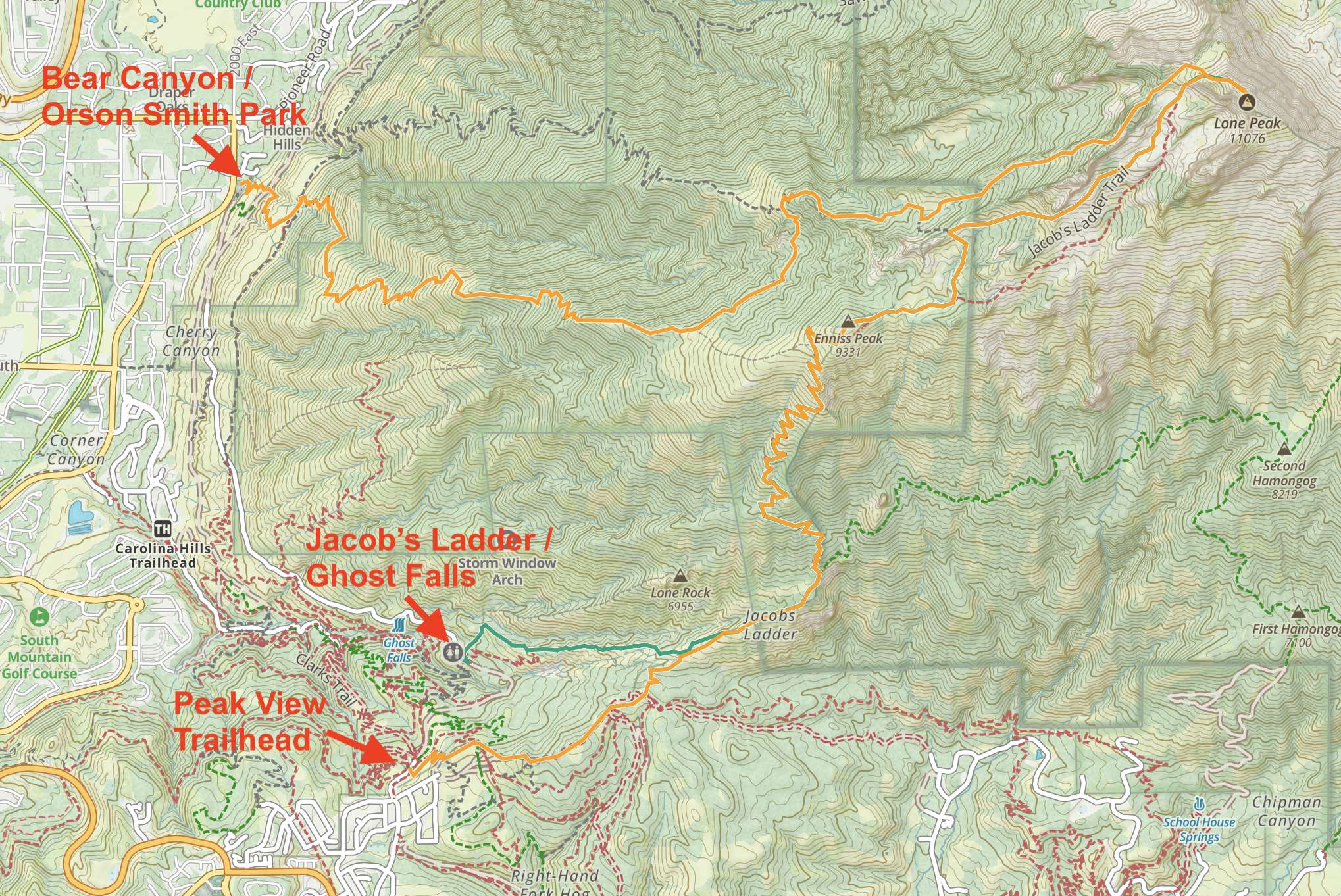
We have created an online map and GPX file for each of the trail options listed above. You can use those links to view an online map of Lone Peak as well.
Camping Info
This hike is located in close proximity to the towns of Draper and Alpine where there is plenty of lodging. In addition, hikers enter a Wilderness area with tons of dispersed camping options within the Wilderness. You can read about rules and regulations of the Lone Peak Wilderness Here. The most common area for camping is the Lone Peak Cirque that sits just short of the summit in a beautiful basin.
Current Weather Conditions:
Here is the detailed weather forecast for the next few days. We highly recommend you check out local weather the morning of your hike.
Granite, UT
Overnight
Mostly clear. Low around 20, with temperatures rising to around 24 overnight. Wind chill values as low as 10. East southeast wind around 12 mph.
Saturday
Sunny, with a high near 46. South southeast wind 13 to 29 mph.
Saturday Night
A chance of rain and snow showers after midnight. Cloudy. Low around 25, with temperatures rising to around 32 overnight. South wind 29 to 35 mph, with gusts as high as 47 mph. Chance of precipitation is 30%. New snow accumulation of less than one inch possible.
Sunday
Snow showers before noon, then snow showers and a slight chance of thunderstorms. Cloudy, with a high near 31. Wind chill values as low as 6. Southwest wind 21 to 29 mph, with gusts as high as 47 mph. Chance of precipitation is 100%. New snow accumulation of 10 to 14 inches possible.
Sunday Night
Snow showers and a slight chance of thunderstorms. Cloudy, with a low around 15. West wind 15 to 18 mph. Chance of precipitation is 90%. New snow accumulation of 7 to 11 inches possible.
Monday
Snow showers likely before noon, then a chance of snow showers and a slight chance of thunderstorms. Cloudy, with a high near 24. Chance of precipitation is 60%. New snow accumulation of 2 to 4 inches possible.
Monday Night
Snow showers likely. Mostly cloudy, with a low around 17. Chance of precipitation is 60%. New snow accumulation of 3 to 7 inches possible.
Directions & Parking
Directions to Peak View Trailhead:
Directions To Jacob’s Ladder / Ghost Falls Trailhead:
Directions to Bear Canyon / Orson Smith Park and Trailhead:
Additional Pictures

Views of the summit form the ridge
Views looking back at Peak View : Jacob’s Ladder Trailhead
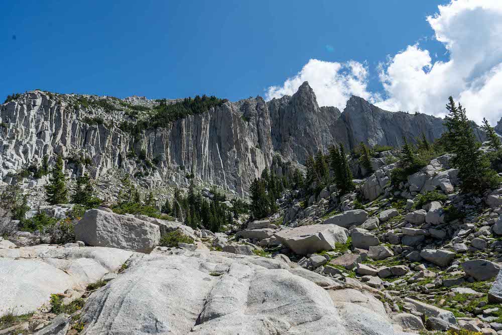
The summit from the basin below
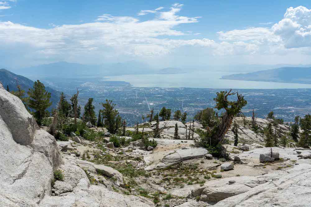
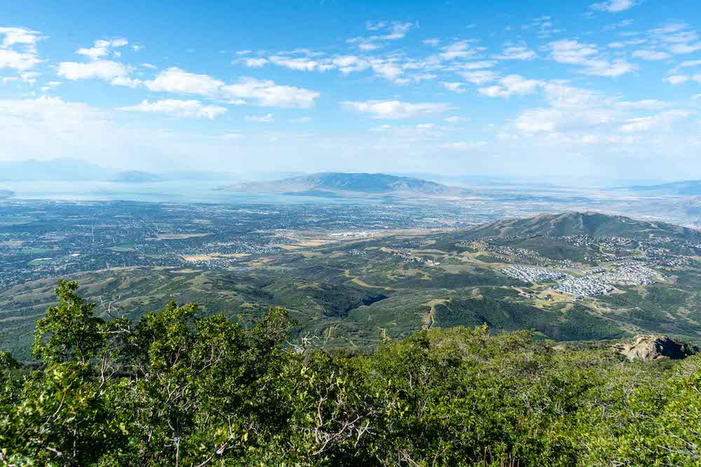
Views of Utah Lake
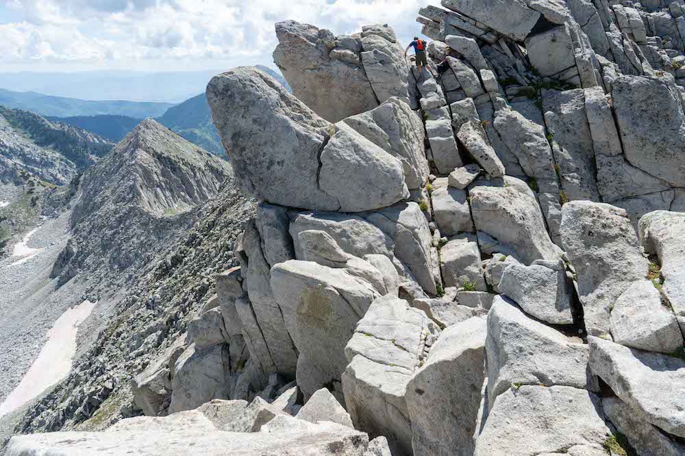
Beginning of class 4 section near the sumit
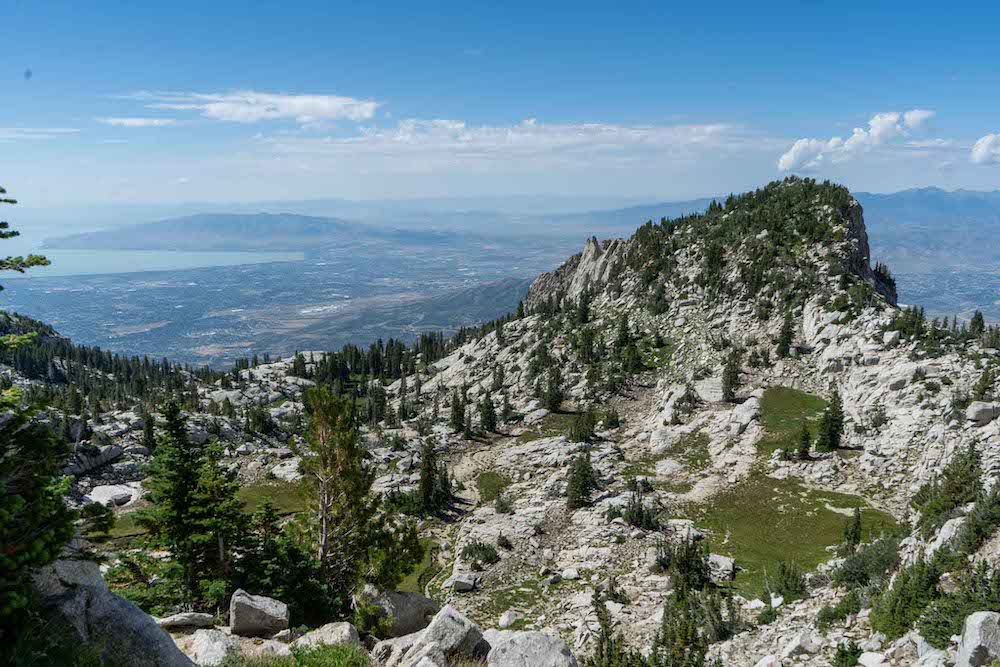
Views from atop the first steep climbing section
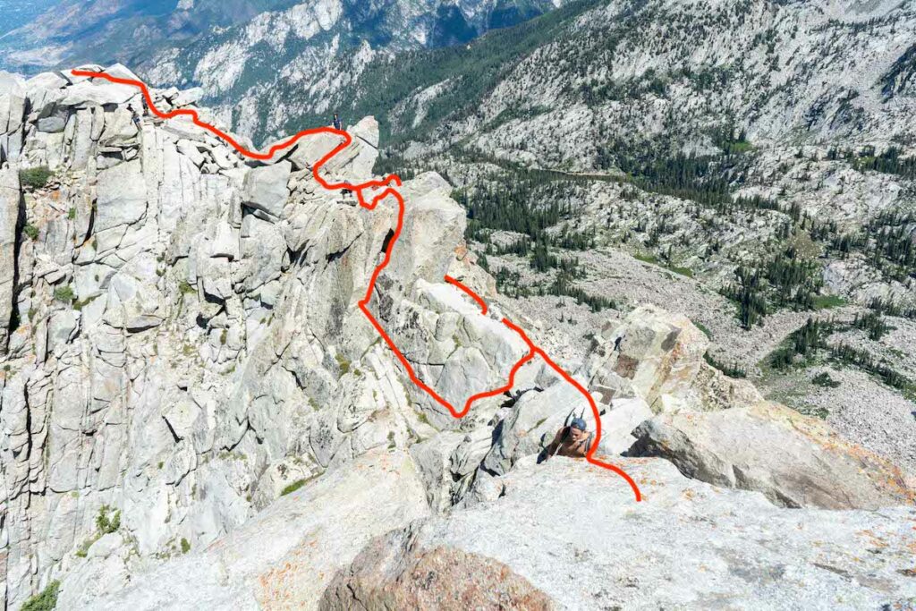
Looking at the class 4 section of the hike

Max DesMarais is the founder of hikingandfishing.com. He has a passion for the outdoors and making outdoor education and adventure more accessible. Max is a published author for various outdoor adventure, travel, and marketing websites. He is an experienced hiker, backpacker, fly fisherman, backcountry skier, trail runner, and spends his free time in the outdoors. These adventures allow him to test gear, learn new skills, and experience new places so that he can educate others. Max grew up hiking all around New Hampshire and New England. He became obsessed with the New Hampshire mountains, and the NH 48, where he guided hikes and trail runs in the White Mountains. Since moving out west, Max has continued climbed all of the Colorado 14ers, is always testing gear, learning skills, gaining experience, and building his endurance for outdoor sports. You can read more about his experience here: hikingandfishing/about
Heaven's Halfpipe Ski
Skied almost the entire road! Great conditions all around. Pretty variable at lower end of halfpipe, but everything above and below skied like a dream. Saw a few other crews out there.
Parking is still crazy confusing. We parked at a pulloff by the lower trailhead on a pulloff on Aspen Drive in Alpine.
The other groups we spoke to parked higher in the neighborhood above.
Great Conditions For October
A fair amount of people on the trail. We had perfect views, calm summit, and a great day! Parked at Alpine View Trailhead.