Zapata Falls is a stunning 30 foot waterfall located only about a 35 minute drive south of Great Sand Dunes National Park, and is accessible via an easy .45 mile (.9 mile round trip) to the falls. Hikers will often have to get wet to see this beauty, and likely will need to arrive early or on off days to avoid the crowds. Here is everything you need to know.
Distance – .9 miles round trip (1.45 km)
Elevation gain – 250 feet (76.2 meters)
Duration – 1 – 2 hours
Difficulty – Easy
Seasons – This hike can be completed in all seasons, but winter involves an icy/frozen river and microspikes are recommended.
Trailhead Location – South Zapata Trail
Quick Navigation:
Routes | Trail Map | Camping Info | Weather | Directions | Pictures
Need To Know Information
- The road to the trailhead is dirt for 3 miles. Any passenger vehicle can make this as high clearance isn’t needed, but be prepared for a slow and bumpy ride. In winter, some vehicles may not be able to make it. This adds a lot to the hiking and elevation gain of this hike.
- The last 75 feet or so to the falls involves walking in the river and on wet rocks. Footing can be difficult and you should plan to get your feet, boots, or sandals wet on this hike.
- There are bathrooms at the trailhead as well as trash, recycling, informational plaques, and a campground.
- Dogs are allowed here.
Zapata Falls Routes
There is only one approach used to get to the falls. Mostly done from the top trailhead, however, we have highlighted the mileage and elevation gain from the bottom of the dirt road.
From Main Trailhead – .9 Miles Round Trip – 250 Feet Elevation Gain
Starting from the main trailhead, hikers will follow the very heavily traveled and well established trail until the trail hits South Zapata Creek. From here, hikers walk up the river to the falls.
From Bottom Of Dirt Road – 7.04 Miles Round Trip – 1,500 Feet Elevation Gain
There is a parking lot at the bottom of the dirt road. Most vehicles can make it up this road, but if snow, ice, or mud conditions stop cars from traveling up the road, hikers will need to walk the road to get to the trailhead.
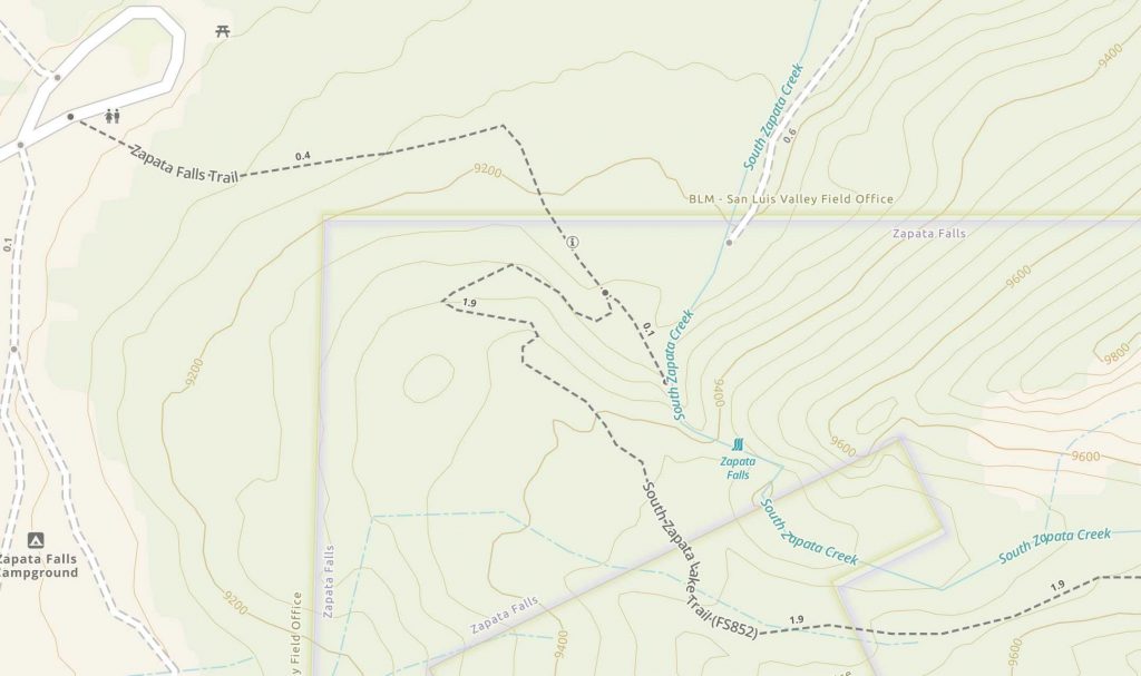
Trail Map
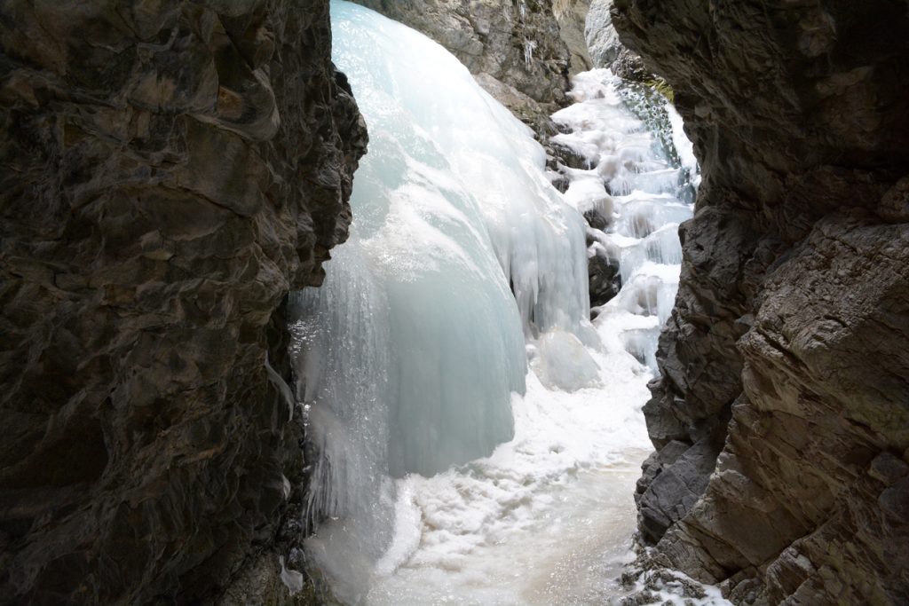
Hiking Zapata Falls In Winter
This is a fantastic winter hike. The trailhead remains open year round, and the falls turn into some crazy ice formations in the winter months. Bring microspikes as the river can be a complete ice sheet at certain times.
Camping For Zapata Falls
Hikers can camp at Zapata Falls Campground where there are camper and tent sites available. In addition, their is backcountry camping on the trail heading towards South Zapata Lake for those that want to do some backpacking.
Hikers may also camp at Great Sand Dunes National Park Pinon Flats campground.
You can read about Zapata Falls Campground here. There are no reservations, and it fills up very fast year round.
In addition, hikers can backpack and camp near the lake. Most camp in flatter sections of the trail about 3 miles in towards the lake.
Current Weather Conditions:
Blanca, CO
Overnight
Mostly clear, with a low around 32. South wind around 5 mph.
Monday
Sunny, with a high near 59. Southwest wind 5 to 15 mph.
Monday Night
Mostly clear, with a low around 39. Southwest wind 10 to 15 mph.
Tuesday
Sunny, with a high near 64. West southwest wind 10 to 20 mph.
Tuesday Night
Mostly clear, with a low around 40. Southwest wind 10 to 20 mph.
Wednesday
Sunny, with a high near 65. Southwest wind 10 to 30 mph, with gusts as high as 45 mph.
Wednesday Night
Mostly clear, with a low around 38. Southwest wind 15 to 25 mph, with gusts as high as 40 mph.
Directions & Parking
2WD vehicles can make it to the main trailhead nearly all the time. Below is a pin to the main trailhead.
Additional Pictures

Max DesMarais is the founder of hikingandfishing.com. He has a passion for the outdoors and making outdoor education and adventure more accessible. Max is a published author for various outdoor adventure, travel, and marketing websites. He is an experienced hiker, backpacker, fly fisherman, backcountry skier, trail runner, and spends his free time in the outdoors. These adventures allow him to test gear, learn new skills, and experience new places so that he can educate others. Max grew up hiking all around New Hampshire and New England. He became obsessed with the New Hampshire mountains, and the NH 48, where he guided hikes and trail runs in the White Mountains. Since moving out west, Max has continued climbed all of the Colorado 14ers, is always testing gear, learning skills, gaining experience, and building his endurance for outdoor sports. You can read more about his experience here: hikingandfishing/about