Indian Rock and Indian Arch in Yosemite National Park are two unique rock formations that is often hiked to by backpackers passing by to other gorgeous spots like North Dome. This area has some great camping nearby, and while it is a long hike for just Indian Rock, this is a great pit stop for longer adventures.
In this article, we will talk about hiking North Dome, Indian Arch, and Indian rock, as if you are going to see Indian Rock or Arch, you should also be visiting North Dome.
Quick Navigation:
Trail Map | Trails | Hiking In Winter | Camping | Directions | Pictures
Difficulty – Intermediate
Distance –8.72 Miles Round Trip (14.03 km)
Height – 7,467 feet (2275.94 m)
Elevation gain –1,995 Feet (608.08 m)
Duration – 5-6 hours round trip
Hike Class: Class 2
Trailhead Location – Porcupine Creek Trailhead (8,117)
Dogs – Not allowed
Need To Know Information
- A permit is required to enter Yosemite at many parts of the year: https://www.nps.gov/yose/planyourvisit/permitsandreservations.htmhttps://www.fs.usda.gov/recarea/arp/recarea/?recid=8080
- Additional permits are not required to hike this trail unless hikers are spending the night at tent sites above, or are hiking to half dome.
- You can hike to North Dome year round, but there are road closures to take into account that would require hikers to hike from the Valley in winter, making this a long hike. Routes are described below. The road closure information can be found here.
Trail Map
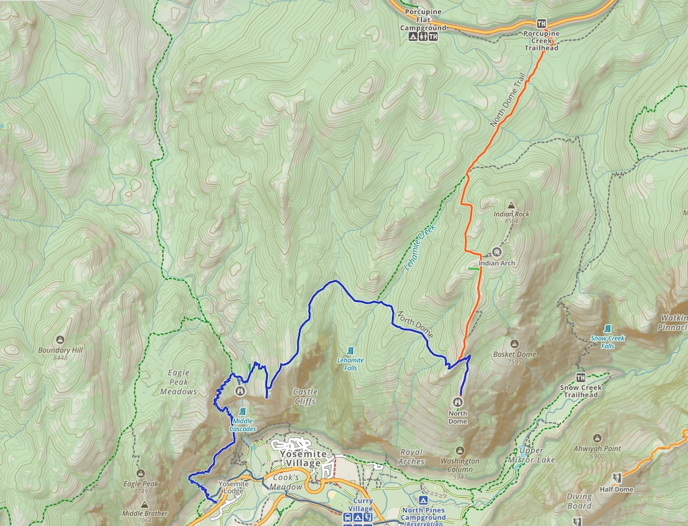
Routes
The main route to Indian Rock is from Tioga Road, which is closed in winter often until late May or June. This route is significantly shorter than the alternative necessary when the road is closed.
The route to Indian Rock and to Indian Arch is a simple out and back route from any trailhead. So they are usually tacked on to other hikes. Here is the information on adding on both Indian Arch and Indian Rock.
Indian Arch Addition:
0.4 miles (.64 km) round trip
200 feet (61 m) elevation gain and loss
Indian Rock Round Trip Addition:
1.2 (1.93 km) miles round trip
403 feet (122.5 m) elevation gain and loss
North Dome From Tioga Road
Distance: 8.72 Miles Round Trip (14.03 km)
Elevation Gain: 1,995 Feet (608.08 m)
Starting at the Porcupine Creek Trailhead, hikers begin several hundred feet higher than North Dome, so they begin descending for about a mile before gradually ascending a little before a mile into the hike. Hikers turn left to head towards Indian Arch and Indian rock (a cool detour) but follow signs towards North Dome. Hikers will reach a trail junction above North Dome with the end of the hike in sight. From here they will drop a steep portion of trail down to the dome outcrop with incredible views. This drop is about 750 feet.
Hikers are rewarded with pretty incredible views just about the entire hike, but the majority of the elevation gain is on the way back to Tioga road. (About 640 feet of incline to North Dome total, and about 1,355 feet of total incline on the way back.)
North Dome From Yosemite Falls Trailhead
Distance: 14.88 Miles Round Trip (23.95 km)
Elevation Gain: 7,565 Feet (2305.81 m)
This is not the recommended route due to the very long hike required for a single day. That being said, it can be done, or this is an amazingly awesome starting point, or end point for an overnight trip (if you get wilderness permits).
This is probably the most efficient way to get to North Dome if Tioga Road is closed.
Hiking in Winter
Refer to trail closures and winter hiking info here.
Camping Information
Nearby lodging and campground information can be found here.
And getting backcountry/wilderness camping permit info can be found here.
Weather
Here is a detailed weather forecast for the area:
Yosemite Valley, CA
Tonight
A chance of rain showers after 11pm. Cloudy. Low around 41, with temperatures rising to around 43 overnight. Southwest wind 0 to 5 mph. Chance of precipitation is 40%. New rainfall amounts between a tenth and quarter of an inch possible.
Friday
A chance of rain showers before 11am, then showers and thunderstorms likely between 11am and 5pm. Mostly cloudy. High near 55, with temperatures falling to around 52 in the afternoon. Southwest wind 5 to 10 mph. Chance of precipitation is 60%. New rainfall amounts between a quarter and half of an inch possible.
Friday Night
Partly cloudy, with a low around 34. Wind chill values as low as 32. North northwest wind 0 to 5 mph.
Saturday
Sunny, with a high near 64. Northwest wind 5 to 10 mph.
Saturday Night
Partly cloudy, with a low around 41. Northeast wind around 5 mph.
Sunday
Sunny, with a high near 68. West southwest wind 5 to 10 mph.
Sunday Night
Mostly clear, with a low around 42. East wind 5 to 10 mph.
Directions
Directions to Mist Trail Trailhead:
Directions to Yosemite Falls Trailhead:
Additional Pictures
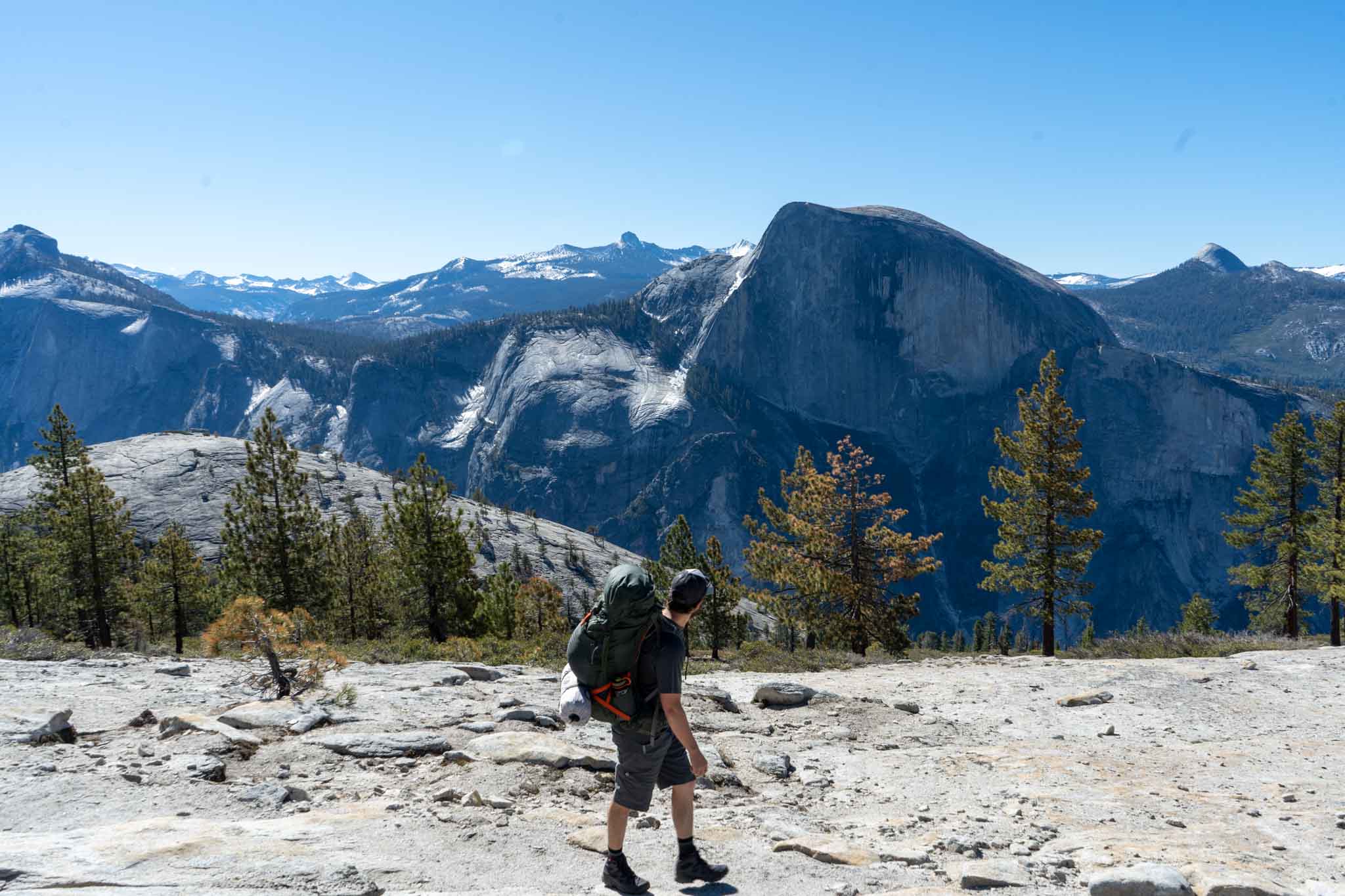
Views approaching North Dome near the final descent to the Dome

Indian Arch

Max DesMarais is the founder of hikingandfishing.com. He has a passion for the outdoors and making outdoor education and adventure more accessible. Max is a published author for various outdoor adventure, travel, and marketing websites. He is an experienced hiker, backpacker, fly fisherman, backcountry skier, trail runner, and spends his free time in the outdoors. These adventures allow him to test gear, learn new skills, and experience new places so that he can educate others. Max grew up hiking all around New Hampshire and New England. He became obsessed with the New Hampshire mountains, and the NH 48, where he guided hikes and trail runs in the White Mountains. Since moving out west, Max has continued climbed all of the Colorado 14ers, is always testing gear, learning skills, gaining experience, and building his endurance for outdoor sports. You can read more about his experience here: hikingandfishing/about