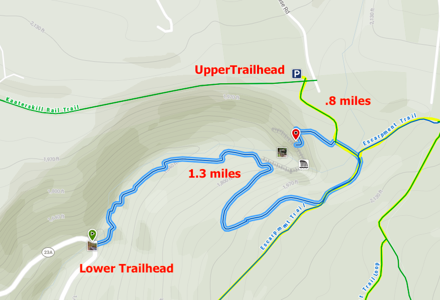
The Trails
Via the Lower Trailhead –
Distance – 2.6 miles roundtrip (4.2 km)
Difficulty – Easy
Duration (book time) – One hour or less
Seasons – Fall, Spring, Summer, Winter
From the parking area, walk carefully along Route 23A, around the sharp bend and downhill towards the trailhead. At the kiosk, the less dramatic Bastion Fall will be to your left as you begin climbing the Yellow Trail. The trail climbs at a moderately steep incline but levels out as you get closer to the falls with the creek to your left. The upper 175-foot falls and the lower 85-foot cascade is a truly beautiful sight to see. Once you’re done admiring the falls, simply retrace your steps the way you came from until reaching the kiosk and Bastion Falls.
Via the Upper Trailhead –
Distance – 2.3 miles roundtrip (3.7 km)
Difficulty – Easy
Duration (book time) – One hour or less
Seasons – Fall, Spring, Summer, Winter
Starting at Laurel House Road just before North-South Lake Campground, follow the wide gravel path to the kiosk. Continue on the flat gravel path until reaching a junction where the Blue Trail splits off to the left. To reach the viewing platform, stay right onto the Yellow Trail with an incredible view from above of the falls. After taking in the view, return to the Yellow/Blue junction and this time, turn left and cross over the bridge. Immediately after crossing the bridge you will arrive at another junction. Turn right and follow the Blue Trail toward Lower Falls, Layman’s Monument, and Inspiration Point. Turn left heading downhill onto the Yellow Trail to visit the lower falls. After enjoying the views of the lower falls, retrace your steps the way you came back to the trailhead parking lot.
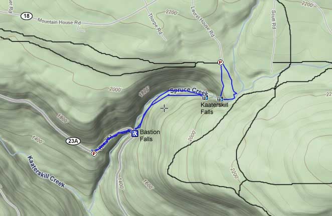
Trail Map
Before You Go
Use extra caution when rocks are wet or icy. Stay on the maintained trail to prevent injury. It is necessary that you use proper foot traction when the trail is covered in ice and snow.
Parking
Lower trailhead parking lot
The parking area for Kaaterskill Falls is located directly off of Scenic Byway Route 23A at the sharp bend in the road crossing in front of Bastion Falls.
Upper trailhead parking lot
Parking for the Upper trailhead to reach Kaaterskill Falls is located on Laurel House Road.
Directions
Getting to the Lower trailhead parking lot
Take New York State Thruway to Exit 21 (Catskill). Take a left out of the NYS Thruway entrance road and drive for approximately 1/4 mile before turning right onto Route 23W. Drive for 6.6 miles to Cairo, NY. Go approximately 6.6 miles to Cairo, NY. Turn left on Route 32 and drive another 7.7 miles. Take a right onto Route 23A and drive roughly 7 miles. After going around the Horseshoe turn (near Bastion Falls), park 1/4 mile past the Falls at Rip’s Lookout.
Getting to the Upper trailhead parking lot
Take New York State Thruway to Exit 21 and turn left out of the NYS Thruway. Drive for 1/4 of a mile before turning right onto Rte. 23 West and continue for another 6.6 miles to Cairo, NY. Turn left onto Rte. 32 and go approximately 7.7 miles before turning right onto Rte. 23A. Stay on this road for 8 miles until reaching the mountain road (Rt 23A). Drive to the top until you reach Haines Falls. Take a right onto North Lake Road and follow along until reaching Laurel House Road on the right side of the road. Turn right onto Laurel House Road and drive to its end and park at the turn-around.
Weather Forecast
Here is a detailed weather forecast for the next four days:
Palenville, NY
Overnight
Clear, with a low around 28. Northwest wind around 8 mph.
Friday
Sunny, with a high near 55. East wind around 7 mph.
Friday Night
Mostly clear, with a low around 34. South wind 5 to 8 mph.
Saturday
Mostly sunny, with a high near 59. Southwest wind 7 to 13 mph, with gusts as high as 23 mph.
Saturday Night
A chance of rain showers before 5am, then a chance of showers and thunderstorms. Mostly cloudy, with a low around 43. South wind 12 to 15 mph, with gusts as high as 25 mph. Chance of precipitation is 50%. New rainfall amounts less than a tenth of an inch possible.
Sunday
A chance of showers and thunderstorms before 5pm, then a slight chance of showers and thunderstorms. Partly sunny, with a high near 68. Chance of precipitation is 40%. New rainfall amounts less than a tenth of an inch possible.
Sunday Night
A slight chance of showers and thunderstorms before 8pm. Mostly cloudy, with a low around 54.
Additional Photos

- Photo credit – Wikipedia Commons


Andrea is a writer, hiker, and adventurer from New England. She enjoys snowboarding, sunrise hikes, winter, night hiking, traveling, and photography.