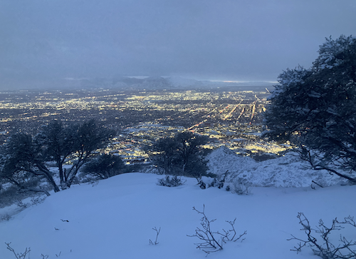
Mount Wire is a stunning hike located in Salt Lake City Utah. It features a tower with a ladder at the top to an old beacon tower, incredible 360 degree views, a steep ascent, and is one of the best overlook spots of the valley below. This peak is also often called “Big Beacon”.
Because of the trail system, there are several ways to reach the summit, we highlight the different options below.
Distance – 4.8 miles round trip (7.72 km)
Height – 7,110 feet (2167.13 m)
Elevation gain – 2,100 feet (643 meters)
Duration – 4-5 hours
Difficulty – Intermediate
Trailhead Location – Colorow Road, Salt Lake City (Directions Below)
Quick Navigation:
Routes | Trail Map | Lodging Info | Weather | Directions | Pictures
Need To Know Information
-
-
- Dogs are allowed on this hike.
- This trail is open year round, but microspikes are highly recommended in winter.
- This is a steep trail, only one option is slightly less steep, but it still remains relatively steep the entire way.
- The tower at the top features a ladder that is about 25 feet tall.
- The road next to the trailhead has free parking, and if lots of spots are taken, just continue down the road further to find more spots.
- The trail isn’t marked, so download a track on your phone, or have a map ready. There are a lot of smaller trails here, so it is easy to take a wrong turn.
-
This Video shows off the views from this stellar hike:
Hiking Route Options
We recommend that most hikers take the Living Room Trail before diverging off of this trail 1.1 miles in onto an unnamed trial. There are several options here, but this option is the least steep and has the easiest to manage trail compared to the other options.
The Living Room Trail | 4.2 Miles Round Trip (7.72 km) – 2,108 Feet Elevation Gain (643 meters)
Hikers begin along Colorow Road and head upwards. There are a couple different paths, all of which hiker can take, and they all eventually converge on the very large, and obvious Bonneville Shoreline Trail. From here, hikers basically cross this trail, and will find a few traveled routes that will take you and converge with the Living Room Trail. It can be a little confusing due to so many small trails from people traveling in different directions, but if any confusion arises, simply ask someone nearby which way to the living room.
Hikers continue upwards 1.1 miles before a bend in the trail. Continuing left, hikers are very the Living Room, but heading to Mount Wire requires a right turn into the trees up a lesser traveled trail up the gully.
From here, hikers continue upwards to the saddle between the Living Room and Mount Wire and then turn right at that saddle to head up towards Mount Wire.
Other Paths To Mount Wire
The other trails to Mount Wire are not well maintained, and are quite steep. They feature various points where there is a steep gradient on gravel, rocks, and sometimes loose rocks. We recommend heading up the Living Room trail at least for your first time up this mountain as the other trails are a bit steeper.
From the BST trail, you can look up at Mount Wire, and you’ll notice there are several somewhat traveled steep paths upwards, from just about any of these, you can continue to the summit – but as stated they are steep. Because of this, they are less mileage, but will take many people longer to ascend.
Hiking Mount Wire In Winter
This hike is accessible in winter, but traction in the form of microspikes should be brought due to icy conditions.
Trail Map
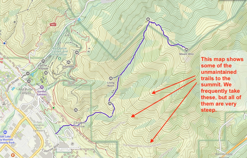 We have created an online map and GPX file you can download and see: View Mount Wire Hike Map and GPX File
Lodging Info
This hike is located on the north end of Salt Lake City, making it a short drive from just about any hotels or AirBnbs in the city. You’ll even find people running to the trailhead, and running up to the living room from their homes in Salt Lake.
Current Weather Conditions:
Here is the detailed weather forecast for the next few days. We highly recommend you check out local weather the morning of your hike.
Emigration Canyon, UT
Overnight
Mostly cloudy. Low around 40, with temperatures rising to around 42 overnight. Northeast wind 3 to 7 mph.
Wednesday
Mostly sunny. High near 50, with temperatures falling to around 47 in the afternoon. West northwest wind 7 to 14 mph.
Wednesday Night
Partly cloudy, with a low around 34. North wind 5 to 9 mph.
Thursday
Mostly sunny, with a high near 55. Southwest wind 5 to 10 mph.
Thursday Night
A chance of rain showers between midnight and 3am, then a chance of rain and snow showers. Partly cloudy, with a low around 39. West northwest wind 6 to 9 mph. Chance of precipitation is 30%.
Friday
A chance of rain and snow showers before noon. Mostly sunny, with a high near 56. Chance of precipitation is 30%.
Friday Night
Mostly clear, with a low around 42.
Directions & Parking
Directions to Main Trailhead. Parking is along the road for free.
In addition, hikers can park at just about any location nearby to access the BST.
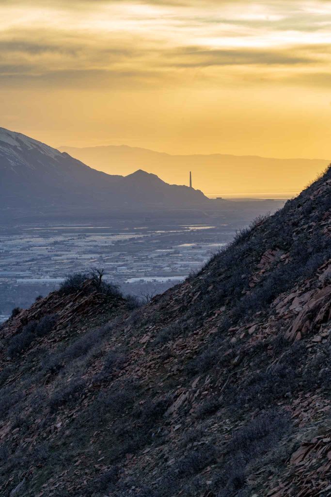
Additional Pictures
Views along The Living Room Trail

Max DesMarais is the founder of hikingandfishing.com. He has a passion for the outdoors and making outdoor education and adventure more accessible. Max is a published author for various outdoor adventure, travel, and marketing websites. He is an experienced hiker, backpacker, fly fisherman, backcountry skier, trail runner, and spends his free time in the outdoors. These adventures allow him to test gear, learn new skills, and experience new places so that he can educate others. Max grew up hiking all around New Hampshire and New England. He became obsessed with the New Hampshire mountains, and the NH 48, where he guided hikes and trail runs in the White Mountains. Since moving out west, Max has continued climbed all of the Colorado 14ers, is always testing gear, learning skills, gaining experience, and building his endurance for outdoor sports. You can read more about his experience here: hikingandfishing/about
Conditions Nearly Perfect
Trail is getting better each day. The mud is limited to only small sections between wire and the living room, and easy to get around.
Great day on the trail.
Stellar Day!
Pretty much all of the trail is in great shape! Only small patches of snow and mud on the saddle between Mount Wire and the living room. Everything else is perfect.