The OnX Backcountry GPS App is a popular navigation tool for outdoor enthusiasts, offering detailed topographical maps, land ownership information, and real-time tracking capabilities. Whether you’re hiking, hunting, or exploring off-road, this app aims to provide everything you need to navigate the backcountry with confidence. But is it worth investing in? In this review, we’ll take a closer look at the features and functionality of the OnX Backcountry GPS App to help you decide if it’s the right choice for your outdoor adventures.
Our Testing
We feel qualified to review OnX Backcountry because we use the app for all our outdoor activities such as hiking, trail running, backcountry skiing, and backpacking. We’re big fans of the convenience and reliability that this app provides in terms of navigation and discovering new trails, but we have also utilized most of the other tools in the marketplace and recognize the shortcomings of this application. We have used this app to plan dozens of trips of varying activities, tracked backcountry skiing days, hikes, and used it heavily for navigation.
Where To Purchase
You can purchase OnX’s products on their site: Onx Maps
About OnX
Eric Siegfried founded onX in 2009 with a vision to help hunters like himself, see public land boundaries while in the field. The product created for hunters was a game changer, and enabled OnX to continue to build out their products to support all types of adventurers.
OnX believes strongly in maintaining public access to lands, which is why they continuously support efforts to secure public access. In addition OnX’s mission is to enable adventurers to be more safe, more prepared, and more capable in the backcountry. You can read about their story and mission here.
Our two largest uses of OnX are for hiking/backpacking, and backcountry skiing. It is worth watching these quick videos on how to use OnX for each of these use cases:
How to Use onX Backcountry for Hiking
How To Use onX Backcountry for Skiing
It is worth noting that OnX has other solutions for hunters, fisherman, and off roaders that are extremely valuable as well.
About The App
In this review – we aren’t going to hit on every single feature for OnX – we are simply going to tell you about what we love, and what see could use improvement. Be sure to check out the full OnX features list as if we were to mention all the features, this review would no longer be helpful.
We also wanted to mention that OnX has been rapidly improving the product over the last 12 months. So much so that we originally weren’t going to review this product, but it has improved so much, that we absolutely love it now.
Key Features
3D Maps
If you are into any mountain sport, visualizing the mountain landscape is super helpful for navigation and planning. Backcountry skiers might find this to be one of the most useful tools. Using your fingers, you can rotate the map, and change angles to get the exact view of the mountain or basin that you plan on exploring. It is immensely helpful. This is an area where OnX improved substantially in the last year.
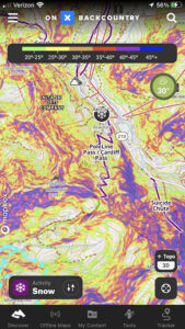
Slope angle overlay in use
Slope Angles Overlay
For understanding steepness, particularly for avalanche danger, this map overlay is essential. The color system and overlay over maps works great on OnX. It is easy to recognize overhead hazards and avalanche terrain with this feature.
Slope Aspect Overlay
Slope aspect is again a feature that is extremely important for backcountry skiers or winter hikers. KNowing the aspect of each slope is essential for understanding avalanche dangers, but also for finding the best quality snow, or even the right aspect for a camping spot.
Topo & Satellite Maps
Being able to toggle between quality satellite maps, and topographic maps is key to reading terrain, planning a route, and navigation. The map quality in OnX is fantastic, and enables for easy route planning and navigation.
Downloadable Maps
This is an absolutely essential feature for any outdoor app. Being in Salt Lake City currently, we have the entire Wasatch range downloaded so that we don’t even need to think about whether we have the map of the area downloaded or not. The feature works great, and allows you to download in high resolution, or in lower resolution.
Route Creation & Waypoints
It is extremely easy to draw routes and drop waypoints. We like this feature. This however does fall a bit short as it isn’t easy to map a route on existing trails. We would like to see a route planning feature that snaps to the trail for better accuracy and ease of route creation on the phone. Our assumption is that this feature will come soon.
We have friends that don’t have some of these apps, and when they join on trips, sometimes we screen record our OnX routes to explain the trip to them. (Record on Windows, Record on Mac)
Route Tracking
Route tracking works great – however it does cut through the phone battery. We rarely use this as we do most of our tracking on our watch. It is still a great feature to have.
Backcountry Ski Guidebook
While not every route is in OnX, the repository is growing, and it is very nice to have common ski routes already described and mapped out for you within the app. This has come in handy many of times.
GPX Uploading
One feature that OnX is lacking on is the ability to upload a GPX file to OnX and have that route on your phone. We have requested this feature and hope it comes out soon. Currently, you can upload to your computer to map it out, but that won’t show up on your phone. So you’d have to manually draw a route after uploading a GPX.
Recommendation And Overall Thoughts:
Overall, we do recommend this app. Historically, we would have recommended other paid apps like FatMap prior to recommending OnX, but we have been thoroughly impressed with the added features. In the last 6 months, OnX has caught up to FatMap substantially, making it comparable on many levels. When it comes down to the final decision, it is more about personal preference. One note, is that it appears OnX is adding features and functionality faster than FatMap. We therefore believe that any features in which it may be behind in, it likely will catch up to FatMap, and potentially surpass.
When it comes to deciding which app is best for you – it is best to try the free version of each app you are considering – and then choose the one that feels best for you. This is a marketplace now where most of the apps have similar features, and a lot of the decision comes down to personal preference.
OnX is likely the best app for anyone that also hunts, off roads, or fishes. This is mainly due to the ability to show off private vs public lands better than any other solution on the market.

Max DesMarais is the founder of hikingandfishing.com. He has a passion for the outdoors and making outdoor education and adventure more accessible. Max is a published author for various outdoor adventure, travel, and marketing websites. He is an experienced hiker, backpacker, fly fisherman, backcountry skier, trail runner, and spends his free time in the outdoors. These adventures allow him to test gear, learn new skills, and experience new places so that he can educate others. Max grew up hiking all around New Hampshire and New England. He became obsessed with the New Hampshire mountains, and the NH 48, where he guided hikes and trail runs in the White Mountains. Since moving out west, Max has continued climbed all of the Colorado 14ers, is always testing gear, learning skills, gaining experience, and building his endurance for outdoor sports. You can read more about his experience here: hikingandfishing/about