Uncompahgre Peak is a 14,321 foot peak in the San Juan mountains of Colorado. Located in the Uncompahgre Wilderness just north of Lake City, this hike features some of the best views in the state, a class 2 approach to the summit, and various camping options long the road. Uncompahgre stands out with its extremely large plateau like summit. In this article, we cover everything you’ll need to hike Uncompahgre.
Quick Navigation:
Trail Map | Trails | Hiking In Winter | Camping | Directions | Pictures
Difficulty – Intermediate to Strenuous
Distance – 7.37 miles round trip (11.86 km) – With high Clearance 4WD vehicle
Height –14,321 feet (4365.0 m)
Elevation gain – 3,234 feet (985.72 m)
Duration – 6 to 7 hours (book time)
Hike Class: Class 2
Trailhead Location – Nellie Creek Trailhead – 11,428 feet or 9,344 feet (4WD vs 2WD)
Dogs – Allowed
Need To Know Information
- This hike has a couple trailhead options that we explain below. The trailheads have 2wd and 4wd parking in which many miles can be cut off with a high clearance vehicle.
- There is plenty of camping along the roads leading the trailheads.
Trail Map
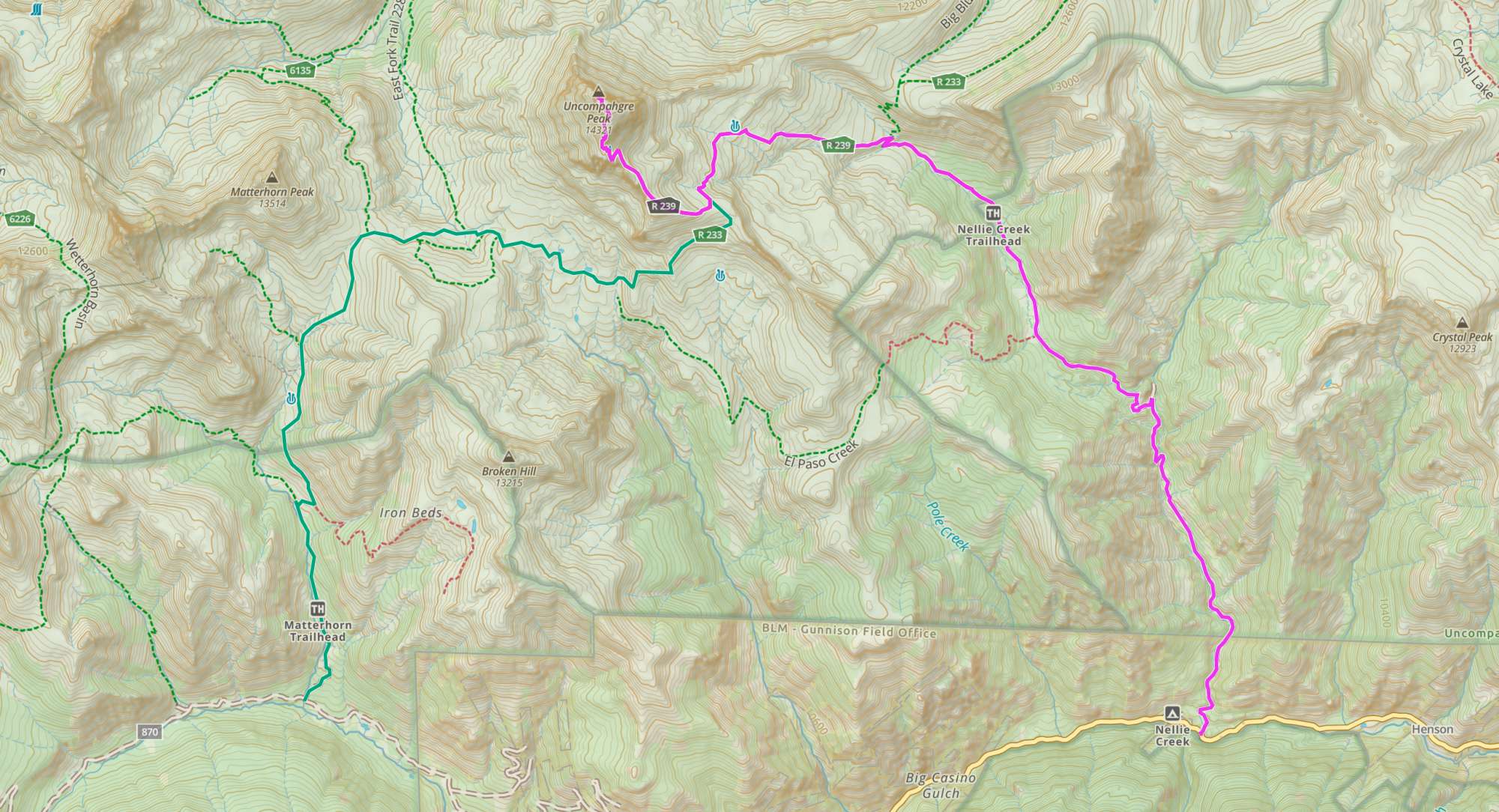
Routes
Nellie Creek 4WD Trailhead – 7.28 Miles (11.72 km) – 3,234 Feet (985.72 m) Elevation Gain
The Nellie Creek Trailhead (Uncompahgre Peak Trail) is the most common trail used to summit. The 4WD trailhead requires high clearance vehicles in order to make it to the top. While it isn’t recommended, you’ll often see cars like Subaru Foresters at the top. Many vehicles equally or less capable choose to park at the two wheel drive trailhead, or park at one of the pull offs available before the road gets really tough. It is a common road for non hikers to travel up in ATVs or other capable vehicles as well.
Overall, the trail is easy to follow and well defined. It gradually gains elevation through the Nellie Creek basin which is absolutely stunning and features incredible views nearly the entire hike. Hikers eventually begin switchbacking up steeper terrain in the last 2 miles of the hike.
The last portion of the hike towards the summit is the most difficult. It would be considered difficult class two, and does feature some rockfall potential, so hikers should be cautious in this section, particularly if other hikers are above or below them. Overall, the trail is easy to follow and remains class 2 or easier for its entirety.
Nellie Creek 2WD Trailhead – 15.4 Miles (24.78 km) – 5,584 Feet (1702.00 m) Elevation Gain
The 2WD trailhead is recommended for vehicles that aren’t capable of making it up the road, or drivers that aren’t comfortable driving on that road. There is a solid amount of parking along Henson Creek road, and campsites available shortly after the sign for the trailhead that 2wd vehicles can access. If parking here, hikers simply follow the road, including two creek crossings, to the 4WD trailhead. The road is long, and features a lot of elevation gain (about 4 miles each way with 2,200 feet of ascent).
Matterhorn Creek 4WD Trailhead – 14.52 Miles (23.37 km) – 5,335 Feet (1626.11 m) Elevation Gain
Another option for hikers is via the Matterhorn Creek trailhead which is the most common route for hiking Mount Wetterhorn. From this trailhead, hikers can head directly towards Uncompahgre, or summit both peaks.
Matterhorn Creek 2WD Trailhead – 15.72 Miles (25.30 km) – 5,760 Feet (1755.65 m) Elevation Gain
Hikers need to also hike a little bit on a rough 4wd road if they do not have a high clearance 4wd vehicle.
Combining Wetterhorn And Uncompahgre
The fastest way to do this is from the Matterhorn Creek Trailhead. From the 4WD trailhead this is 16.0 miles and 7,033 feet of elevation gain round trip. Add a little bit on the 2WD road if needed.
Hiking in Winter
This is a fantastic winter hiking option. The hike will need to be extended to the 4WD trailheads most likely. As with any 14er, it should only be attempted in winter by experienced hikers with avalanche training and understanding.
Camping Information
Henson Creek road, the 2wd trailhead, and along the road to the 4WD trailhead all contain several camping options. Keep in mind that this area is busy during the summer months, but hikers can often find camping spots at or near the trailheads, or along Henson Creek road.
Weather
Here is a detailed weather forecast for the area:
Allenspark, CO
Tonight
Partly cloudy, with a low around 36. West southwest wind 7 to 12 mph, with gusts as high as 18 mph.
Thursday
Showers and thunderstorms between noon and 5pm, then a slight chance of thunderstorms and rain and snow showers. Partly sunny. High near 56, with temperatures falling to around 47 in the afternoon. Southwest wind 6 to 15 mph, with gusts as high as 28 mph. Chance of precipitation is 80%. New rainfall amounts less than a tenth of an inch possible.
Thursday Night
A slight chance of thunderstorms and rain and snow showers likely. Cloudy. Low around 33, with temperatures rising to around 35 overnight. West wind 16 to 32 mph, with gusts as high as 48 mph. Chance of precipitation is 70%. Little or no snow accumulation expected.
Friday
A chance of snow showers before noon, then snow showers and a chance of thunderstorms. Mostly cloudy, with a high near 48. West northwest wind 13 to 35 mph, with gusts as high as 52 mph. Chance of precipitation is 80%.
Friday Night
Snow showers and a chance of thunderstorms. Cloudy, with a low around 29. West wind 3 to 10 mph, with gusts as high as 16 mph. Chance of precipitation is 90%. New snow accumulation of 2 to 4 inches possible.
Saturday
Snow showers before 9am, then snow showers and a chance of thunderstorms. Cloudy, with a high near 38. Chance of precipitation is 100%. New snow accumulation of 5 to 9 inches possible.
Saturday Night
Snow showers and a slight chance of thunderstorms. Cloudy, with a low around 28. Chance of precipitation is 90%. New snow accumulation of 3 to 5 inches possible.
Directions
Each of the below are to the 4wd trailhead, which will take hikers directly past the 2wd trailhead.
Directions to Nellie Creek Trailhead:
Directions to Matterhorn Creek Trailhead:
There are no day hike parking fees here at either trailhead.
Additional Pictures
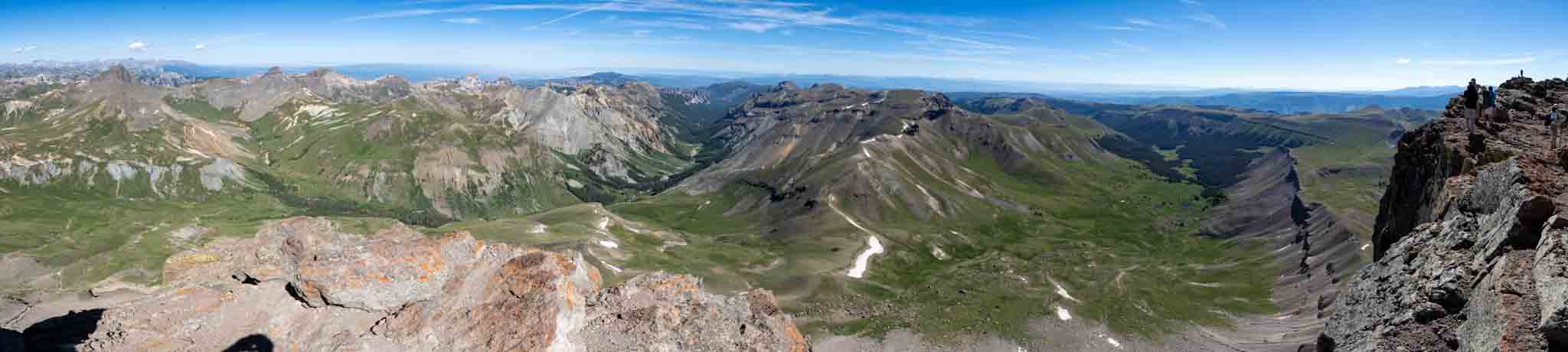
Panoramic views from the summit of Uncompahgre
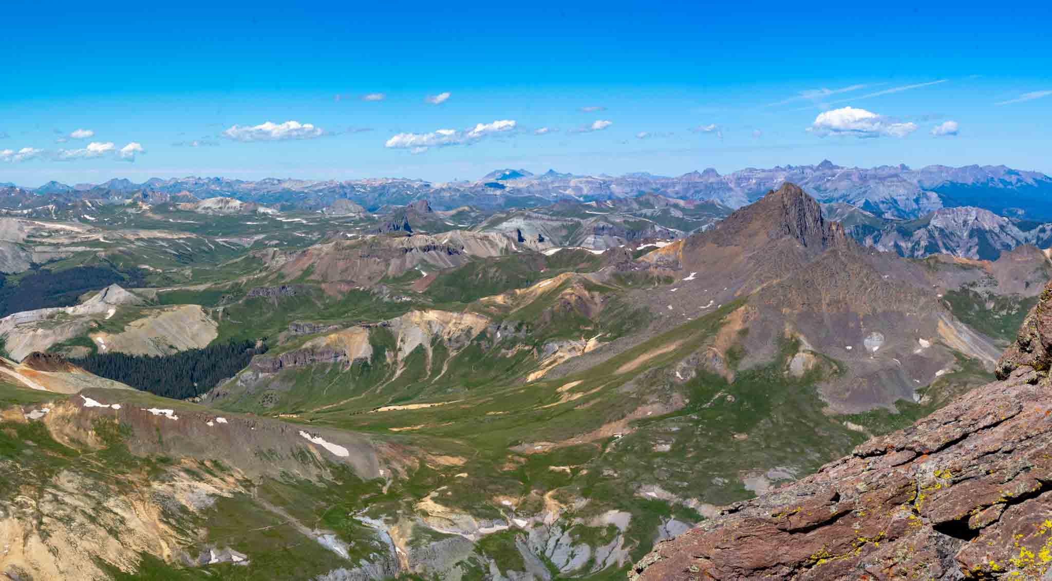
Views of Wetterhorn from the summit of Uncompahgre
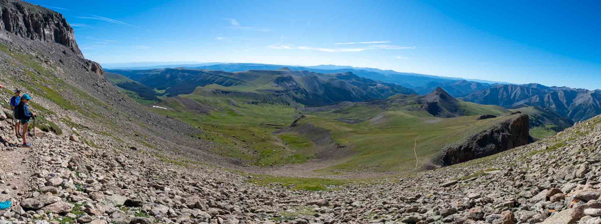
Views looking into the Nellie Creek Basin
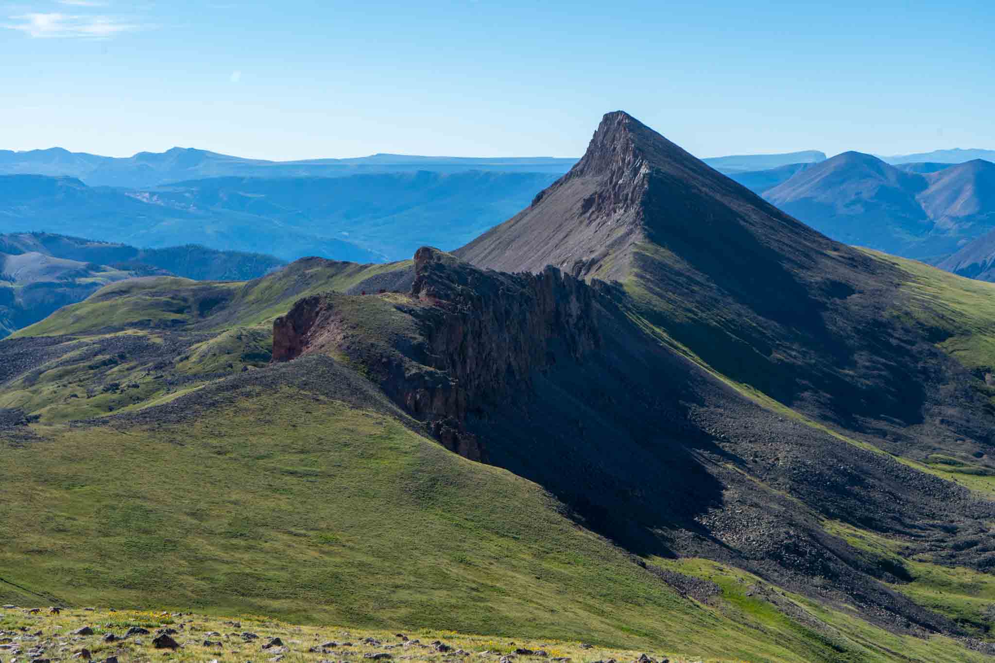
Views heading up Uncompahgre

Max DesMarais is the founder of hikingandfishing.com. He has a passion for the outdoors and making outdoor education and adventure more accessible. Max is a published author for various outdoor adventure, travel, and marketing websites. He is an experienced hiker, backpacker, fly fisherman, backcountry skier, trail runner, and spends his free time in the outdoors. These adventures allow him to test gear, learn new skills, and experience new places so that he can educate others. Max grew up hiking all around New Hampshire and New England. He became obsessed with the New Hampshire mountains, and the NH 48, where he guided hikes and trail runs in the White Mountains. Since moving out west, Max has continued climbed all of the Colorado 14ers, is always testing gear, learning skills, gaining experience, and building his endurance for outdoor sports. You can read more about his experience here: hikingandfishing/about