The Wildcat Ridge contains gorgeous mountains in Pinkham Notch, extending to Carter Notch about 5 miles away. The Ridge contains Wildcat Mountain (A Peak – 4,000 footer), Wildcat B, Wildcat C, and Wildcat D (4,000 footer). Hiking along the ridge you will find incredible views of Mount Washington, views into Carter Notch, and go right through one of New Hampshire’s Iconic ski areas. (Hiking is a bit more rewarding than the Gondola).
WILDCAT MOUNTAIN (WILDCAT A) |
|
|---|---|
| Elevation | 4,422 feet (1,348 m) |
| Distance | 8.6 miles |
| Elevation Gain | 2,950 feet |
| Duration | 3-5 hours |
| Difficulty | Strenuous |
WILDCAT D |
|
| Elevation | 4,062 feet (1,238 m) |
| Distance | 4.4 miles |
| Elevation Gain | 2,450 feet |
| Duration | 3-5 hours |
| Difficulty | Strenuous |
WILDCAT RIDGE |
|
| Elevation | 4,062 feet (1,238 m) |
| Distance | 8.4 miles |
| Elevation Gain | 3,850 feet |
| Duration | 4-7 hours |
| Difficulty | Strenuous |
Trail Map
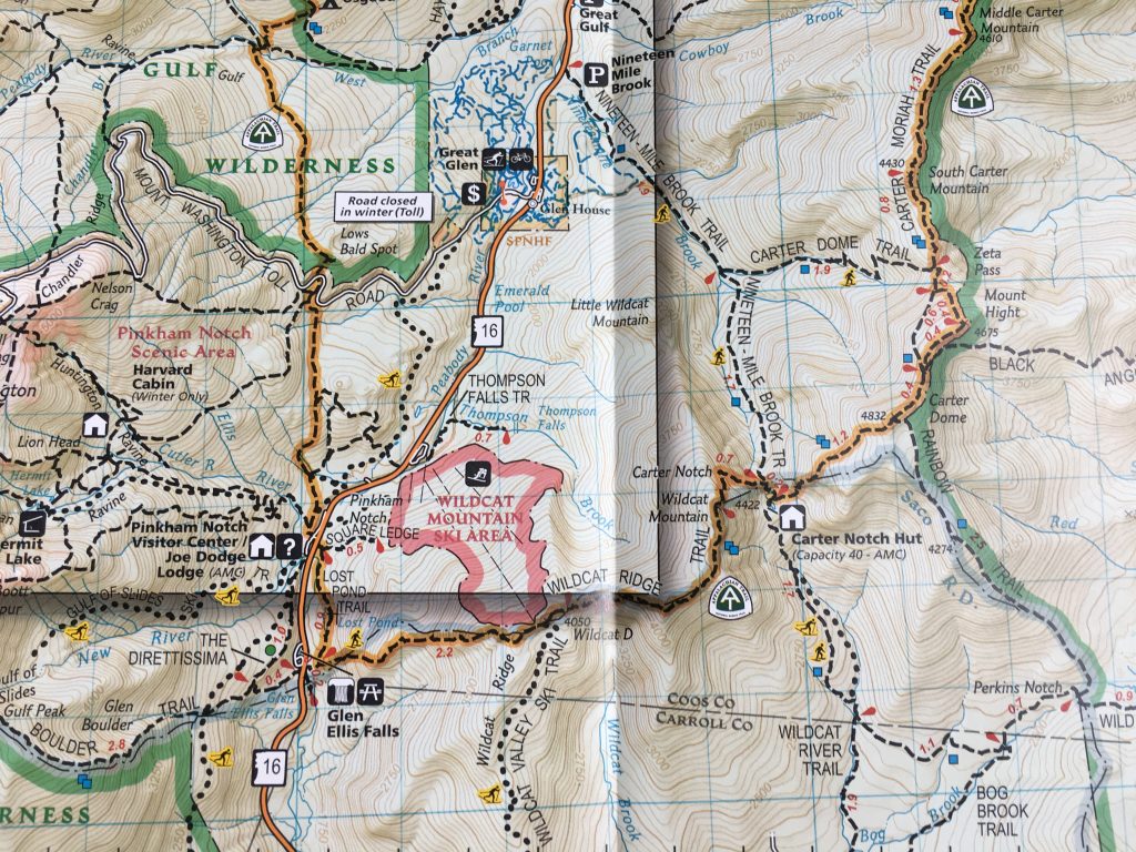
Trails
Wildcat Ridge Trail
The Wildcat Ridge Trail begins on NH 16 at the Glen Ellis Falls parking area (directions below). This trail steeply ascends to Wildcat D. You will immediately cross the Ellis River, which can be difficult to cross during high water. If water is too high to cross, hikers can park at Pinkham Notch Visitors center, and follow the Lost Pond Trail towards Wildcat D.
D peak Only | 4.4 Miles | 2,450 feet elevation gain
All Peaks | 8.4 Miles | 3,850 feet elevation gain
Nineteen-Mile Brook Trail
The nineteen-mile brook trail also starts on NH 16. There is a parking lot for this trailhead on the east side of 16. This trail follows a brook up to Carter Notch with relatively gradual elevation gain. At Carter Notch you will find the Carter Notch AMC Hut and Carter lake. You will see Carter Dome rise to the North, and Wildcat A rise to the south. Once you reach the lake, the trail gets very steep on the ascent up to Wildcat A.
A Peak Only | 8.6 Miles | 2,950 feet elevation gain
All Peaks | 12.6 miles | 4,450 feet elevation gain
Other Approaches
Hikers can also choose to ascend the Wildcats from Jackson, NH on Carter Notch Rd. This is the longer trip of 10.4 miles (Just Wildcat A), or 14.4 miles with all peaks. This trail is longer, but starts at a higher elevation.
Views
There are many great viewpoints that stare back into Pinkham Notch, Mount Washington and Tuckerman Ravine while ascending the Wildcat Ridge Trail. Wildcat D has a viewing platform with outstanding views. On Wildcat Mountain, hikers also get fantastic views of Carter Notch, Carter Dome, and the Carter-Moriah Range. Ascending the Nineteen-Mile Brook trail gives hikers great views of the brook during the ascend.
Hiking in Winter
The Wildcat Ridge Trail starting at Glenn Ellis falls isn’t the recommended winter path due to very steep trails and ledges that can be dangerous. The nineteen mile brook trail is far more gradual. Hikers should still be cautious here as the trail gets very steep once in Carter Notch and beginning the ascent to Wildcat A where the slide trail can be ice and a bit difficult. Crampons are essential either way. Many hikes choose to ascend via ski trails in the winter, but be cautious of skiers. Wildcat Mountain allows hikers to hike up.
Hiking Up The Wildcat Ski Trails
The designated uphill route is Stray Cat to Middle Polecat to Catnap to Upper Polecat. Uphill access is permitted before and after operating hours (before 8:30am – after 4pm). Dogs are not allowed for uphill access on the ski trails.
You can read about this here: https://www.skiwildcat.com/the-mountain/about-the-mountain/mountain-info.aspx
Directions
To Wildcat Ridge Trailhead (Glen Ellis Falls Parking Lot)
To Nineteen-Mile Brook Trailhead
Weather Forecast
Gorham, NH
This Afternoon
Sunny, with a high near 38. Northwest wind 15 to 20 mph, with gusts as high as 35 mph.
Tonight
Clear, with a low around 17. Northwest wind 10 to 15 mph, with gusts as high as 30 mph.
Friday
Sunny, with a high near 47. Northwest wind 10 to 15 mph, with gusts as high as 25 mph.
Friday Night
Mostly clear, with a low around 27. Northwest wind 5 to 15 mph, with gusts as high as 25 mph.
Saturday
Mostly sunny, with a high near 52. Southwest wind 5 to 15 mph, with gusts as high as 25 mph.
Saturday Night
Rain showers likely after 8pm. Mostly cloudy, with a low around 37. Chance of precipitation is 60%.
Sunday
Rain showers likely. Mostly cloudy, with a high near 55. Chance of precipitation is 60%.

Max DesMarais is the founder of hikingandfishing.com. He has a passion for the outdoors and making outdoor education and adventure more accessible. Max is a published author for various outdoor adventure, travel, and marketing websites. He is an experienced hiker, backpacker, fly fisherman, backcountry skier, trail runner, and spends his free time in the outdoors. These adventures allow him to test gear, learn new skills, and experience new places so that he can educate others. Max grew up hiking all around New Hampshire and New England. He became obsessed with the New Hampshire mountains, and the NH 48, where he guided hikes and trail runs in the White Mountains. Since moving out west, Max has continued climbed all of the Colorado 14ers, is always testing gear, learning skills, gaining experience, and building his endurance for outdoor sports. You can read more about his experience here: hikingandfishing/about