Yosemite National Park is one of America’s outdoor treasures. First protected in 1864, the park became America’s third national park in 1890 and was designated as a World Heritage Site in 1984. It is one of the largest non-fragmented habitat blocks left in the continental United States, and is home to black bears, bighorn sheep, elk, mountain lions, and hundreds of other animal species. Yosemite is known for its incredible views, as well as some of the best-beloved trails and climbs in the National Park System.
If you’re planning a trip to Yosemite, it can be hard to know which hikes are the best options for you. The park is huge; it covers 759,620 acres, or 1,187 square miles. It pays to know in advance which trails you want to experience. Today, we’re going to go over some of the best hikes in Yosemite National Park, including some hikes that are great for beginners. Let’s dive in!
Best Hikes in Yosemite Map
After visiting Yosemite a few times and hiking the most popular trails, as well as some of the less popular trails, we have compiled a list of the best hikes, and created a map including all of our picks.
Best Hikes in Yosemite for Beginners
These easy Yosemite hikes are perfect for newcomers to the sport of hiking. They’re a great introduction to the national park and can be completed in an afternoon. Keep in mind that all of the easiest, most accessible hikes in the park can get really crowded in summer– but the views are stunning year-round, so they’re worth doing no matter when you go.
Lower Yosemite Falls
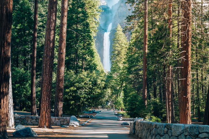
Yosemite Falls is a stunning waterfall, and there are two easy approaches to the lower falls trail. One is from a direct trailhead; the other is a short hike from Yosemite Village. Hikers get close views of the lower falls, a 320-foot waterfall… in comparison, Niagara Falls is 187 feet at the tallest point of Horseshoe Falls. Up close, that is the only falls visible, but while approaching, the upper falls, can be seen which drop 1,430-feet (440 m). In total, the waterfalls drop 2,425 feet (739 m) from the top to the bottom in 3 sections: Upper Falls (1,430 feet), Middle Cascades (675 feet) and Lower Falls (320 feet).
The trail is paved and wheelchair accessible on the eastern approach, so this is a great trail for people of all abilities.
- Length: 0.5 miles round trip from trailhead; 1.5 miles round trip from Yosemite Village
- Elevation: 3,967 feet
- Elevation Gain: Minimal
- Duration: 20 mins-1 hour
- Highlights: Stunning waterfall views at the start and end, good easy hiking experience for families
Read Our Full Guide On Yosemite Falls
Sentinel and Cook’s Meadow Loop
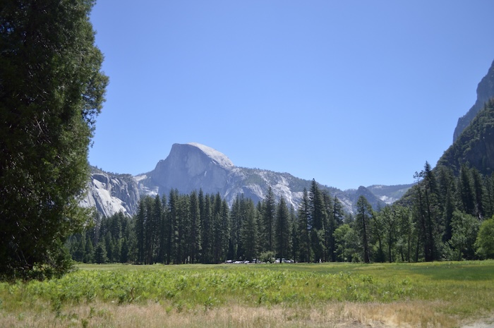
View of Half Dome from Cook’s Meadow in Yosemite National Park
This beautiful intro trail to Yosemite features a sampler of the great views the park has to offer. As you take this flat trail through two meadows, over the Merced River over a charming swinging bridge, and have incredible views of Half Dome and Yosemite Falls, you’ll fall in love with the alpine wildflowers and amazing views. This trail can get a little crowded, so you might want to do it in spring or fall rather than summer. It’s also a very flat trail that you could take a wheelchair or stroller over.
- Length: 2.25 miles
- Elevation: 4,000 feet
- Elevation Gain: None
- Duration: 1-2 hours
- Highlights: Beautiful mountain meadows, two river crossings, great views of Yosemite Falls and Half Dome
Taft Point and Sentinel Dome
Views from near the top of Sentinel Dome
These easy hikes share a trailhead, and many people do them together for an intermediate hike. The two trails offer phenomenal views of Yosemite Falls, Half Dome, and El Capitan, as well as other rock formations. Going up by Sentinel Dome takes you through primordial forest, while taking the Taft Point trail winds you past deep canyons and stone fissures.
- Taft Point Length: 2.2 miles
- Taft Point Elevation: 7,700 feet
- Taft Point Elevation Gain: 200 feet
- Taft Point Duration: 1-2 hours
- Sentinel Dome Length: 2.2 miles
- Sentinel Dome Elevation: 7,700 feet
- Sentinel Dome Elevation Gain: 430 feet
- Sentinel Dome Duration: 1-2 hours
- Highlights: Great scenery, ability to combine the two for an intermediate hike that takes about 3-4 hours to complete
Read Our Guides On Sentinel Dome and Taft Point
Best Hikes in Yosemite for Intermediate Skill Levels
Want to hike Yosemite and have more of a challenge? The following hikes are for you! They don’t have any terrain that’s too technical, but they’re a little harder than our easy hikes. These hikes have plenty of beautiful vistas and natural sights that they’re worth it for more advanced hikers, too.
Mist Trail: Vernal, and Nevada Falls
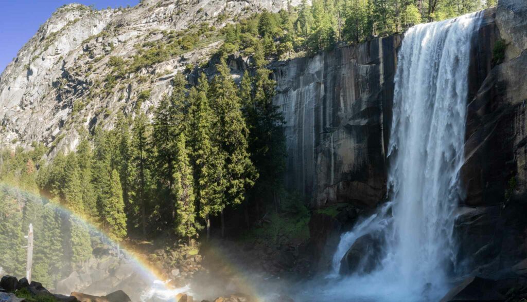
Vernal Falls on the Mist Trail
The Mist Trail on its own (without the Cloud’s Rest connection) is considered one of the must-do trails in Yosemite. Like many other Yosemite trails, there are a few approaches to this one, too. It’s beloved for its amazing views of Vernal and Nevada Falls, as well as its rugged terrain and access to Half Dome and the John Muir Trail.
- Length: 2.4 miles round trip to Vernal Falls, 5.8 miles round trip to Nevada Falls, add 1.5 miles round trip if hiking from Curry Village
- Elevation: 4,059 feet
- Elevation Gain: 1,000 feet
- Duration: 8+ hours to Nevada Falls
- Highlights: Beautiful scenery, lots of connections, canyon views, two waterfalls
Read Our Complete Guide On The Mist Trail
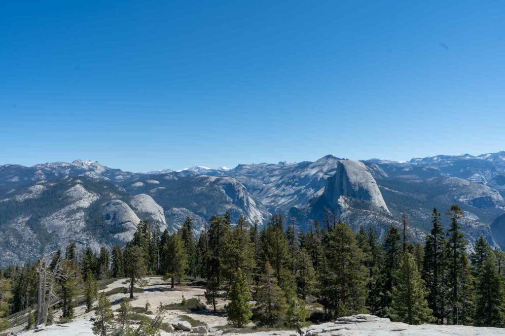
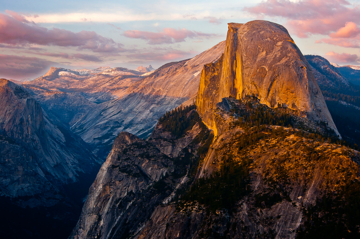
Cloud’s Rest
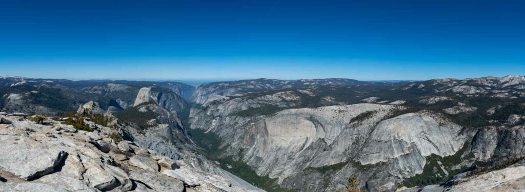
Cloud’s Rest summit views
Cloud’s Rest offers incredible 360º views of Half Dome; it has some of the best views in the entire park. There are technically two approaches to Cloud’s Rest, the Sunrise Lake Trailhead and the Mist Trailhead. The Sunrise Lake Trailhead is the more popular of the two approaches and is six miles shorter; the Mist Trailhead is usually included as part of multi-day hikes, since it’s over 18 miles long. However, if you can get permits for the Mist Trailhead, it can be worth it for its amazing views of Vernal and Nevada Falls.
It’s worth noting that this is a long hike even though it isn’t technically challenging, it is important to understand the overall distance of this hike. In addition, at certain times of the year, starting at Sunrise Lake can mean getting your feet wet as the river crossing may require dipping your feet in.
- Sunrise Lake Length: 12.5 miles
- Sunrise Lake Elevation: 9,926 feet
- Sunrise Lake Elevation Gain: 3,100 feet
- Sunrise Lake Duration: 8-10 hours
- Sunrise Lake Highlights: Water crossing, excellent views of Half Dome
- Mist Trailhead Length: 18.04 miles
- Mist Trailhead Elevation: 4,059 feet
- Mist Trailhead Elevation Gain: 7,223 feet
- Mist Trailhead Duration: 12+ hours
- Mist Trailhead Highlights: Two waterfalls, proximity to Little Yosemite Valley Campground
Read Our Complete Guide To Cloud’s Rest
Indian Rock and Indian Arch
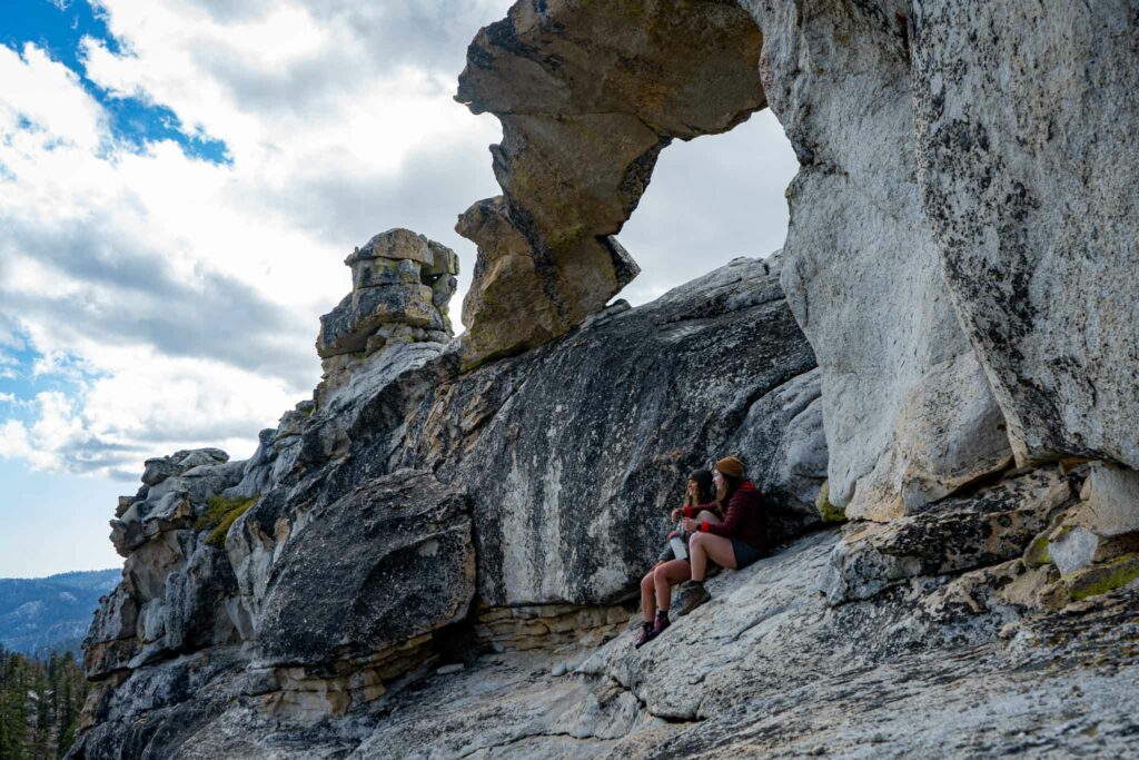
Indian Rock and Indian Arch are two interesting rock formations on a trail that offers great sky visibility– perfect for a backpacking campsite if you like stargazing. These rock formations are also on the way to North Dome, so this trail is perfect as a leg of a longer backpacking trip. It’s also a less-popular trail, so it’s a really good spot to see wildlife. This is recommended as a must stop if heading to North Dome!
- Length: 8.72 miles
- Elevation: 7,467 feet
- Elevation Gain: 1,995 feet
- Duration: 5-6 hours
- Highlights: Interesting rock formations, great pit stop on longer hikes, good camping nearby, great spots for stargazing at night
Read Our Complete Guide To Indian Rock & Indian Arch
North Dome
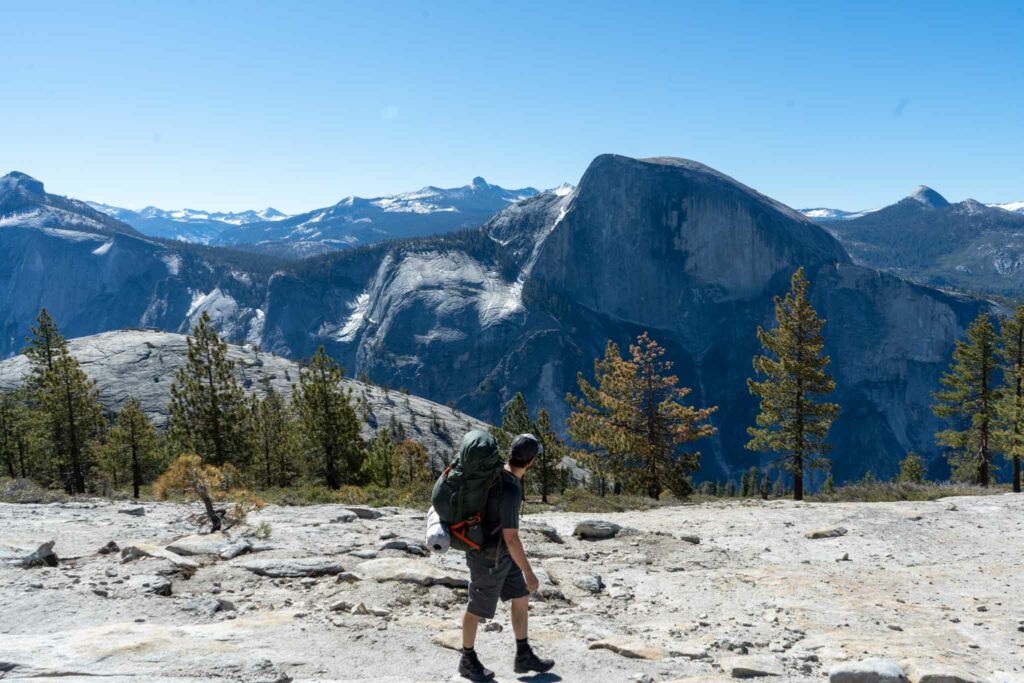
North Dome is one of the most underrated hikes in Yosemite. The views of Half Dome are unmatched, the steep drop offs and views into the valley are unparalleled by nearly every other spot in the park, and the crowds are relatively small on top of this dome.
The views from North Dome might just be the best views in all of Yosemite.
Adding North Dome to your backpacking trip is highly recommended.
- Difficulty – Intermediate
- Distance – 8.72 Miles Round Trip (14.03 km)
- Height – 7,467 feet (2275.94 m)
- Elevation gain –1,995 Feet (608.08 m)
- Duration – 5-6 hours round trip
- Highlights: Less traveled area with what might be Yosemite’s best views.
Best Hikes in Yosemite for Experts
Yosemite has plenty of challenges for outdoor enthusiasts– including some of the most famous rock climbs in the world, like Half Dome and El Capitan. But even if you’re not a climber, there is plenty of challenging terrain in the park. Here are some of our favorite expert hikes for those who really want to see how tough Yosemite can be.
Yosemite Falls
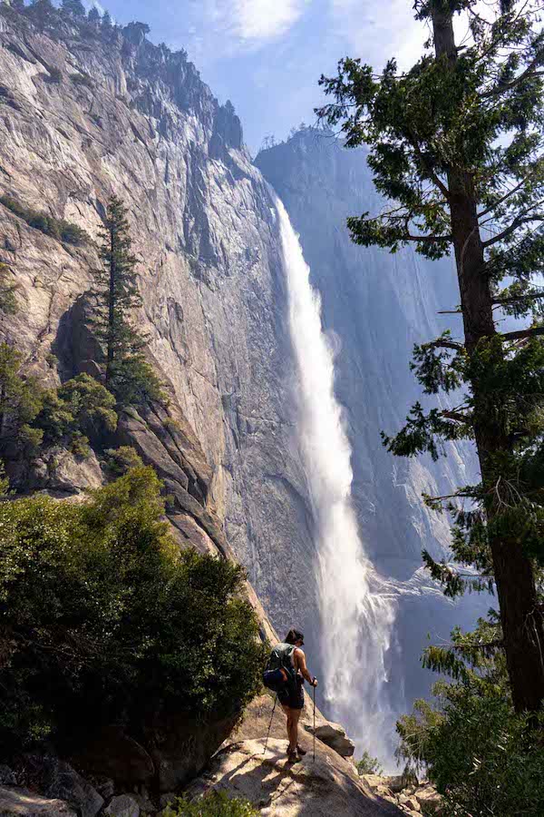
Yosemite falls trail views
If you’ve already had a taste of the falls on the easier Lower Falls hike and want to see the whole thing, Yosemite Falls is a truly stunning hike. Yosemite Falls is one of the tallest waterfalls in the world, over ten times the height of Niagara Falls. It’s an incredible sight you will never forget, and while the full trail may be challenging, it’s absolutely worth it. There are several viewpoints and connecting trails if you’d like to make this hike longer or shorter. There are railings at the very top, but this is not the trail to choose if you’re afraid of heights.
- Length: 7.6 miles
- Elevation: 3,967 feet
- Elevation Gain: 2,700 ft
- Duration: 6-10 hours
- Highlights: Stunning waterfall views
Read Our Guide To Yosemite Falls
Half Dome
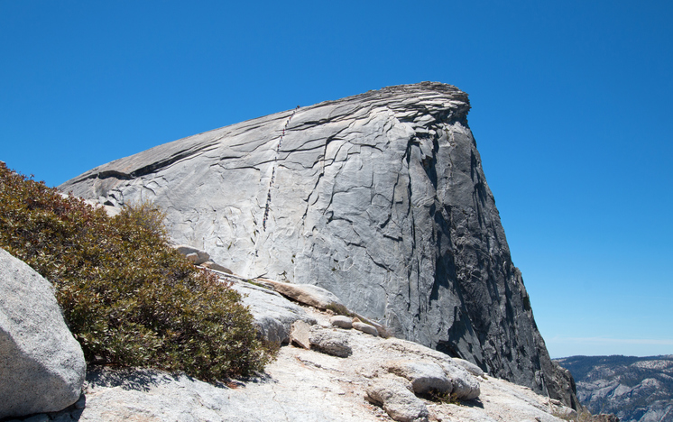
Half Dome is a relatively long day hike, and is tough to do as an overnight due to difficult backpacking permits, though you can camp at backcountry sites with a permit nearby. It’s the most challenging day hike in Yosemite, but one that’s on plenty of hikers’ bucket lists. This challenging hike includes a cable ladder. There are multiple trail approaches that lead to the Half Dome, including from various campgrounds and trails that allow camping. You absolutely need to bring gloves on this hike so you can grip the cables, as well as the grippiest shoes you have; otherwise you’ll never make it up the granite face.
Half Dome requires a permit which is often extremely difficult to get due to its popularity and lottery system.
- Length: 7 miles round trip from Little Yosemite Valley campground
- Elevation: 8,846 feet
- Elevation Gain: 4,800 feet
- Duration: 10-14 hours
- Highlights: Unsurpassed views, serious bragging rights
The Four-Mile Trail
Despite the name, this difficult Yosemite hike is actually closer to 5 miles long. It takes you from Yosemite Valley to Glacier Point and lets you really see what Yosemite National Park is all about. As you climb out of the forests to the alpine meadows, you’ll see stunning views of Yosemite Falls- it’s one of the only trails in the park that gives you an unfettered view of the falls with no obstructions. To the west, you’ll see Cathedral Rocks and El Capitan, and you’ll pass almost directly under Sentinel Rock. Once you hit the upper part of the trail, you’ll be able to see Half Dome, Cloud’s Rest, North Dome, and more.
- Length: 4.7 miles
- Elevation: 7,200 feet (at Glacier Point)
- Elevation Gain: 3,200 feet (from Yosemite Valley)
- Duration: 3-5 hours one way
- Highlights: Everything. You will see virtually all of the most famous sights in the park on this trail.
Tips for Hiking in Yosemite
During peak season (June to August), there is a lot of traffic in the park. Parking in the Yosemite Valley is often full, but transit options from nearby locations like Fresno and Merced are available– as well as a free shuttle bus in the park.
Park Permit System
Yosemite now has a permit system during peak seasons. Please read about the dates permits are needed, and how to acquire them here.
Yosemite Seasons
Yosemite is beautiful year-round, but the experience can vary depending on the season. Spring and early summer offer waterfalls at their peak, while fall provides vibrant foliage. Winter brings snow and fewer crowds. Be aware of the weather conditions and plan accordingly.
Bears
Yosemite’s bears are known for their persistence, so much so that park personnel have had to come up with some innovative ways to discourage them. Store food in bear-proof containers or lockers, and never leave food unattended. Familiarize yourself with bear safety guidelines provided by the park.
Trail Permits
Many Yosemite trails require permits, including wilderness permits if you plan to camp. These permits aren’t expensive, but do sell out fast. You need to plan your Yosemite hikes early! There are lottery permits, too, but it wouldn’t be fun to get out there with all your gear and not get picked for a permit.
Yosemite National Park is an amazing place to hike, no matter your skill level. If you’re trying to find the best Yosemite hike, you should check out our Hike Picker. All you have to do is put in what you want out of a hike and it will give you some amazing options tailored to your needs. Experience the majesty of Yosemite with one of these awesome hikes!

Max DesMarais is the founder of hikingandfishing.com. He has a passion for the outdoors and making outdoor education and adventure more accessible. Max is a published author for various outdoor adventure, travel, and marketing websites. He is an experienced hiker, backpacker, fly fisherman, backcountry skier, trail runner, and spends his free time in the outdoors. These adventures allow him to test gear, learn new skills, and experience new places so that he can educate others. Max grew up hiking all around New Hampshire and New England. He became obsessed with the New Hampshire mountains, and the NH 48, where he guided hikes and trail runs in the White Mountains. Since moving out west, Max has continued climbed all of the Colorado 14ers, is always testing gear, learning skills, gaining experience, and building his endurance for outdoor sports. You can read more about his experience here: hikingandfishing/about