Zion National Park is known for its incredible beauty. Those looking for great hikes never miss out on the most popular hikes, Angel’s Landing, and Observation Point, but Zion has more to offer. If you are looking for a slightly more difficult trek, and to avoid the crowds, Cable Mountain could be a great choice. Pictures of this gorgeous hike are available at the very bottom of this article. This hike has made our list of The Best Hikes in Zion National Park.
Difficulty: Strenuous
Distance: 15 Miles Round Trip (24.14 Km)
Elevation: 6,496 Feet
Elevation Gain: 2,400 Feet
Duration: 7-12 hours
Trails
Weeping Rock Trailhead – 15 miles round trip – 2,400 feet of elevation gain
This is the most common route to Cable Mountain. Hikers can take the Zion Shuttle to the weeping rock stop, and begin ascending Zion Canyon just like hikers would for Observation Point.
East Entrance – 18 miles round trip – 1,000 feet of elevation gain
This trail is a bit longer in distance but considered easier due to the elevation gain.
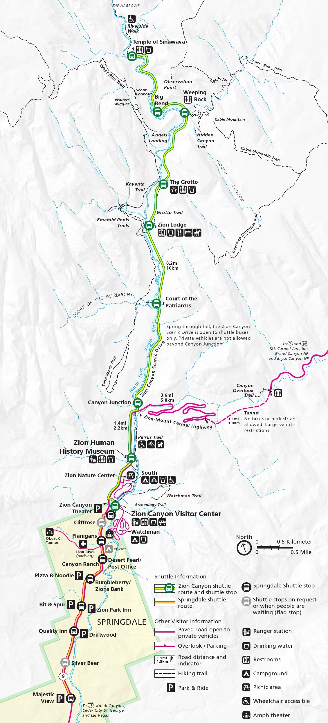
Trail Map
If you are looking for trail maps of Zion, they are surprisingly hard to come by on the internet. You can purchase some great ones on Amazon here. They are also at welcome centers for the park. Below is a map of Zion Canyon which shows the Cable Mountain Trail.
Hike Description from Weeping Rock
Hikers quickly ascend via a heavily switchbacked into the stunning echo canyon. From the trailhead, you experience the towering walls of Zion Canyon and a view backwards to the trailhead and Angel’s Landing. You will continue through Echo Canyon and along the same path hikers take to ascend Observation Point.
Hikers will eventually reach the point where the east rim trail breaks off from the observation point trail. Here you will certainly be leaving the crowds as you traverse across slick rock, and a far less defined path. Here the trail is often marked by small cairns, and can be a little difficult to follow at times. The views here are fantastic, and you come across many astounding white rock formations. This portion of the trail begins relatively flat, but then quickly ascends to the next level upwards above canyon walls.
Once this ascent is complete, your trek to the summit and viewpoint is flat and likely filled with mule deer.
Hike Description from East Entrance
This trek is less strenuous, but also less stunning. Hikers will need to be dropped off, or park a car at the East Entrance Trailhead. Hikers gradually ascend around 1,000 feet towards deertrap mountain and cable mountain. The hike is pleasant, though does not have any stunning cliff views until the very end.
Dogs are not allowed for this hike.
History of Cable Mountain
The cable structure was erected in 1901 to transport lumber down into the canyon from the plateau above. By 1930, the lumber transport was stopped, but the frame of the structure still stand.
Camping
This is a longer mileage hike, and many hikers choose to spend the night, turning this into a multi-day trek. This is highly recommended as both the sunset, and sunrise on Cable Mountain is stunning. When camping, you will need to obtain a Wilderness Permit.
Wilderness Permit
Wilderness Camping permits can be obtained at the Zion National Park Visitor Center. There are very specific areas in which camping is allowed. A hike up Cable Mountain gives hikers tons of options, and speaking with rangers at the visitor center will make finding a spot for your trip very easy. You can also obtain maps pointing to all the legal camping places once you obtain a permit.
PERMIT COSTS:
$15 for 1-2 people
$20 for 3-7 people
$25 for 8-12 people
Hiking in Winter
At its coldest, monthly average high temperatures for a day are in the low 40s, making this a hike that can be completed year round in most conditions. Occasionally there will be ice build up on the trails in which extreme caution should be taken. Simply prepare with the proper equipment and understand the expected weather for your winter excursion to Cable Mountain.
Directions
To Weeping Rock Trailhead:
To East Entrance Trailhead:
Weather Forecast
Springdale, UT
Overnight
Rain and snow showers likely. Cloudy, with a low around 35. West wind around 6 mph. Chance of precipitation is 60%.
Saturday
A chance of rain and snow showers before noon. Partly sunny, with a high near 55. North northwest wind 7 to 14 mph. Chance of precipitation is 30%.
Saturday Night
Mostly clear, with a low around 33. North wind 5 to 14 mph.
Sunday
Sunny, with a high near 63. North northwest wind 3 to 10 mph.
Sunday Night
Mostly clear, with a low around 38. North wind 2 to 10 mph.
Monday
Sunny, with a high near 67.
Monday Night
Clear, with a low around 41.
Pictures

Panoramic shot from the cliffs on top of Cable Mountain

Sunset on Cable Mountain

Views looking back towards Echo Canyon

Echo Canyon views from the trail

Views looking towards Observation Point

Max DesMarais is the founder of hikingandfishing.com. He has a passion for the outdoors and making outdoor education and adventure more accessible. Max is a published author for various outdoor adventure, travel, and marketing websites. He is an experienced hiker, backpacker, fly fisherman, backcountry skier, trail runner, and spends his free time in the outdoors. These adventures allow him to test gear, learn new skills, and experience new places so that he can educate others. Max grew up hiking all around New Hampshire and New England. He became obsessed with the New Hampshire mountains, and the NH 48, where he guided hikes and trail runs in the White Mountains. Since moving out west, Max has continued climbed all of the Colorado 14ers, is always testing gear, learning skills, gaining experience, and building his endurance for outdoor sports. You can read more about his experience here: hikingandfishing/about