If the name Lost Coast Trail conjures up images of epic ocean views, high bluffs, and rugged California coastline, you’d be absolutely right! But let me tell you, it’s even better than you imagined. This wild and untouched stretch of coastline is a playground for thrill-seekers, and if you’re reading this, it means you’re one of them.
This guide will cover all the essential information you need to plan your Lost Coast Trail adventure.
The Lost Coast Trail at a Glance
Trail Location: Along the northern California coastline nestled within the King Range Conservation Area.
Trail Length: Approximately 25 miles one way.
Trail Difficulty: Rated as moderate/strenuous due to the challenging terrain, including sandy beaches, rocky areas, and beach hazards.
Elevation Gain: +/- 1,000 feet of elevation gain with a peak elevation of ~150 feet.
Points Of Interest: Stunning coastal vistas, a decommissioned lighthouse, pristine beaches, dramatic cliffs, tide pools, and abundant wildlife, including black bears, coyotes, seals, and other marine life.
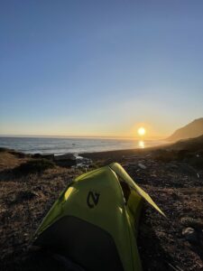
Camping on the Trail: The trail offers a number of primitive campsites. Overnight stays at these locations require permits.
Water Availability: The Lost Coast Trail offers easy access to freshwater streams. Filtering your water is strongly recommended.
Tides: Three sections along the Lost Coast Trail become impassable during high tide. You should consult a tide table and align your start date and hiking itinerary around low tide periods.
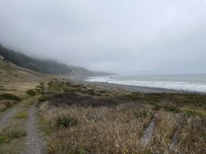
Weather Conditions: A coastal climate characterizes the trail’s weather patterns, including fog, wind, and rain. While summer offers more temperate and pleasant conditions, the winter can bring inclement weather and increased rainfall. Be prepared for changing conditions and pack gear appropriate to the season.
Trail Accessibility: Accessing either end of the Lost Coast Trail is a demanding task, as the area is remote, untamed, and far removed from any urban or populated centers. The roads leading to the trailheads are rough. For the most part, cell reception is scarce or non-existent. Prioritize your safety by leaving a detailed itinerary with a trusted individual and taking a Personal Locator Beacon (PLB) device in an emergency.
Lost Coast Trail Map
We created a GPX file with waypoints of the entire route that you can download and view here: Lost Coast Trail Map
What is the Lost Coast Trail?
 Located five hours north of San Francisco, the Lost Coast Trail is tucked among the rugged coastline of the King Range Conservation Area, encompassing approximately 68,000 acres of wilderness. The trail offers a dramatic landscape of pristine sandy beaches, towering cliffs, rocky shorelines, and tide pools brimming with marine life.
The Lost Coast area has been home to Native American tribes like the Sinkyone and Mattole for thousands of years, with their presence still felt today. In the mid-20th century, plans to construct the Pacific Coast Highway through this area were abandoned due to the unforgiving landscape, preserving the untouched wilderness of the Lost Coast.
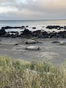
The trail and its surroundings teem with diverse wildlife. Harbor seals, sea lions, and elephant seals can be spotted lounging on the shores or playing in the waves. The adjacent King Range Conservation Area provides a sanctuary for a wide range of animal species, such as black bears, bobcats, deer, coyotes, and a variety of resident and migratory birds.
With its diverse coastal and mountain ecosystems, the Lost Coast Trail is a haven for nature enthusiasts and wildlife lovers alike.
How To Get a Permit To Hike the Lost Coast Trail
A permit is required for overnight camping in the King Range Wilderness year-round, including the Lost Coast Trail.
The trail has exploded in popularity in recent years. Here’s what you need to know to snag one of these coveted permits.
The Lost Coast Trail operates on a year-round quota system.
- Between May 15th and September 15th, 60 persons are permitted to start per day.
- Between September 16th and May 14th, 30 persons are permitted to start per day.
- The block of permits for each calendar year is released the preceding year on October 1st (e.g., 2024 permits are available October 1st, 2023).
Other important information you should know about permits:
- You need to stick to the entry date specified on your permit. If tides or weather are against you on the dates you’ve applied for, it’s best to cancel your permit and reapply.
- Non-commercial permits are limited to three people per group. So, if you have five members in your hiking group, the other two will need a separate permit.
- Permits are non-transferable.
- For organized or commercial groups, a Special Recreation Permit is required.
- If you no longer plan to use your permit, be considerate of other adventurers and cancel it for someone else to use.
- Check the tide tables before you apply for a permit. Depending on the tide levels, the trail may not be passable for most of the day. Check out the “Tide Safety Guide” on the BLM King Range website for more information.
- Applying for a wilderness permit is free, however, Recreation.gov charges a $6 reservation fee.
Apply for your Lost Cost Trail permit
Do this before you apply for a permit
Determine the Best Time To Hike
 In general, May to October are the best months to hike the Lost Coast Trail. Daytime temperatures hover between a comfortable 60-70° with a lower likelihood of precipitation or inclement weather.
If you decide to take on the trail during winter, make sure you’re prepared with extra rain gear. No matter what time of year you plan to hike, it’s always a good idea to check with the local BLM office for the latest weather updates before you hit the trail.
Study Your Tidal Chart
During high tides, parts of the Lost Coast Trail become completely impassable. Consult the tidal chart for the dates you wish to hike. Before you leave, print it out and save an extra copy to your phone. As high tide times change throughout the year, make sure you have the most up-to-date tidal chart for your trip date.
Choose the Direction of Your Hike
When it comes to choosing which direction to hike on the Lost Coast Trail, you have two options: northbound or southbound. Most people prefer to hike southbound because the wind usually blows in that direction, making the trail more enjoyable. On the other hand, if your tidal chart doesn’t look promising, it might make more sense to go northbound.
Preparing for Your Lost Coast Hike
Set Yourself Up For Success
 Don’t be fooled by the lack of elevation; this trail packs a punch with its demanding physical hurdles. Beach hiking is no joke! Check out our dedicated backpacking training guide here to prepare for the trip.
Pack Everything You Need
If you’re planning to hike the Lost Coast Trail, you’ll need more than just the 10 Essentials. Grab our backpacking checklist for a complete list of what you’ll need.
Access Points and Transportation Options
You can access the Lost Coast Trail from two points: the trail’s northern terminus at Mattole Beach just outside Petrolia and Black Sands Beach in Shelter Cove. Figuring out transportation logistics is like solving a Rubik’s Cube.
Many hikers leave their vehicles at the trailhead and catch a shuttle to the opposite side. The cost of the shuttle varies depending on the size of your group, averaging around $95 per person. The shuttle trip typically takes around 2 hours and covers winding, rough, and not-so-well-maintained roads. If you’re prone to car sickness, it might help to bring some medication.
You can arrange shuttle transportation with Lost Coast Adventure Tours by calling 707-382-1959 or reserving your shuttle online. I also recommend joining the Lost Coast Trail Facebook Group to stay on top of trail updates and for help with transportation logistics.
Navigation Tools and Maps
- PLB Device: Along with an online and paper map, you should also carry a GPS device that pulls double duty as a PLB. Your PLB will keep you on track with precise trail coordinates, weather updates, and help in case of an emergency. Just make sure to pack extra batteries or have a way to recharge it on the trail.
- Trail Guidebook: A comprehensive trail guidebook specific to the Lost Coast Trail can be very helpful. You’ll get an overview of the trail’s highlights, water sources, camping spots, landmarks, and any other useful trail-specific tidbits.
- Park Regulations and Information: Familiarize yourself with the park regulations and any information provided by the BLM. They’ll share essential details about permits, camping restrictions, water sources, and any temporary closures or trail updates.
What To Expect on the Lost Coast Trail
 Lost Coast Trail Campsites: If you come in a day before your hike, you have a few options for camping:
Camping at Mattole Trailhead Area: There is a car campground at Mattole that has 14 tent/trailer campsites with picnic tables, fire rings, and vault toilets. The camping fee is $8.
Camping near Shelter Cove: The closest options to Shelter Cove are the BLM Wailaki Campground, the Nadelos Campground, or Tolkan Campground. If you’re looking to camp over the weekend in the summer, get there as early as possible, as these campgrounds have limited capacity.
The main campsites on the Lost Coast Trail are at Cooskie Creek, Randall Creek, Spanish Creek, Kinsey Creek, Big Creek, Big Flat, Shipman Creek, Buck Creek, Gitchell Creek, and Horse Mountain Creek.
Water Sources and Filtration Methods: Fresh water is plentiful along the Lost Coast Trail. That doesn’t mean harmful pathogens and icky stuff can’t end up in it, so I highly recommend packing a filter and treating your water.
On-Trail Hazards: As you venture along the Lost Coast Trail, it’s important to be vigilant for obvious and hidden dangers that may cross your path. Here are a few to remember:
Sneaker waves: These large, powerful waves can surge out of the sea unexpectedly, catching unaware hikers off guard. Hikers have died on the Lost Coast Trail due to sneaker waves. Stay alert and never turn your back to the ocean, especially when hiking close to the water’s edge.
Wildlife encounters: The Lost Coast Trail is home to a variety of wildlife, and while encounters can be awe-inspiring, it’s important to keep a respectful distance. Seals, sea lions, and elephant seals like to rest on the shores. Don’t get too close, and avoid disturbing them. Additionally, black bears, bobcats, and other animals inhabit the surrounding areas, so proper food storage and wildlife awareness are crucial. Bear canisters are required on the Lost Coast Trail.
Ticks: Ticks, those tiny arachnids with a penchant for latching onto unsuspecting hikers, lurk in the coastal brush and high grasses. You can prevent tick bites by wearing long clothing, applying permethrin to your gear, and performing thorough tick checks when you get to camp.
Poison oak: This three-leafed menace can cause itching, rashes, and discomfort for those unfortunate enough to brush against it. Learn to identify poison oak’s distinct leaves and consider wearing long pants and sleeves as a protective measure.
Unstable cliffs and falling rocks: Portions of the Lost Coast Trail traverse rugged cliffs. Erosion can create unstable conditions, so use caution, stay on the trail, and avoid venturing too close to cliff edges. Falling rocks can also be a hazard, so be mindful of loose rocks and cliffs above you while hiking.
Lost Coast Trail FAQs
Can I Take My Dog on the Lost Coast Trail?
While you can technically take your dog on the Lost Coast Trail, the trail’s rough terrain and variable weather conditions can pose challenges for dogs, making it an unsafe environment for them. I’d recommend leaving your fur baby at home for this one, but you know your pup and their limitations best.
Can I Have Fires on the Lost Coast Trail?
Campfires are prohibited on the Lost Coast Trail from approximately mid-June through mid-October.
Can I Bring a Drone on the Lost Coast Trail?
No. Drone use is strictly prohibited on the Lost Coast Trail.
Do I Need a Bear Canister on the Lost Coast Trail?
Bear canisters are required on the Lost Coast Trail (and can be rented ahead of time if you need them).
Don’t forget to bookmark this guide and the helpful resources listed below to help you prepare for your Lost Coast Trail backpacking trip!
- How To Poop In The Woods and Proper Outdoor Bathroom Etiquette
- Blister Prevention And Treatment For Hiking & Other Activities
- How To Plan & Prepare For Your First Backpacking Trip
- Beginner’s Guide to Ultralight Backpacking
- How To Train For A Thru-Hike
- The Complete Guide to Hiking at Night [Gear & Tips To Stay Safe]
- Backpacking Checklist: Essential Items for Camping
- The Complete Beginner’s Guide to Backpacking: Everything You Need to Know

Ash Czarnota is a freelance writer based in Southern California with over 3,000 trail miles under her feet. She is the founder of Go Galavanting, an online community to celebrate adventurous women and highlight emerging thought leaders in the outdoor industry. A PCT alumni, Joshua Tree enthusiast and burgeoning climber, Ash uses her outdoor experiences to craft content that educates and inspires a rising generation of adventurers to embrace their inner wild. Connect with her on Instagram (@salty_millennial).