The Loch (Loch Vale) is a beautiful lake located in Rocky Mountain National Park, Colorado. The lake sits at 10,190 feet, making this a great moderate hike. Accessible in all four seasons, this hike features stunning views of the surrounding peaks (Taylor Peak and Thatchtop Mountain).
Difficulty – Intermediate
Distance – 5.7 miles miles round trip (9.17 km)
Height – 10,190 feet (3,105.9 meters)
Elevation gain – 1,040 feet (316.99 meters)
Duration – 3 to 5 hours (book time)
Seasons – Year-round
Trailhead Location – Glacier Gorge Trailhead or Bear Lake Trailhead
Need To Know Information
- During a large portion of the year, Rocky Mountain National Park requires permits. Permits can be purchased here along with all other relevant info: https://www.recreation.gov/timed-entry/10086910
- Other permit info (You should read this information): https://www.nps.gov/romo/planyourvisit/timed-entry-permit-system.htm
- Dogs are not allowed in Rocky Mountain National Park
- Hikers can park at either Glacier Gorge, or Bear Lake as both are great starting options for doing a loop hike.
- Parking fills up, so the shuttle system in the park can be used when it does.
Trail Map
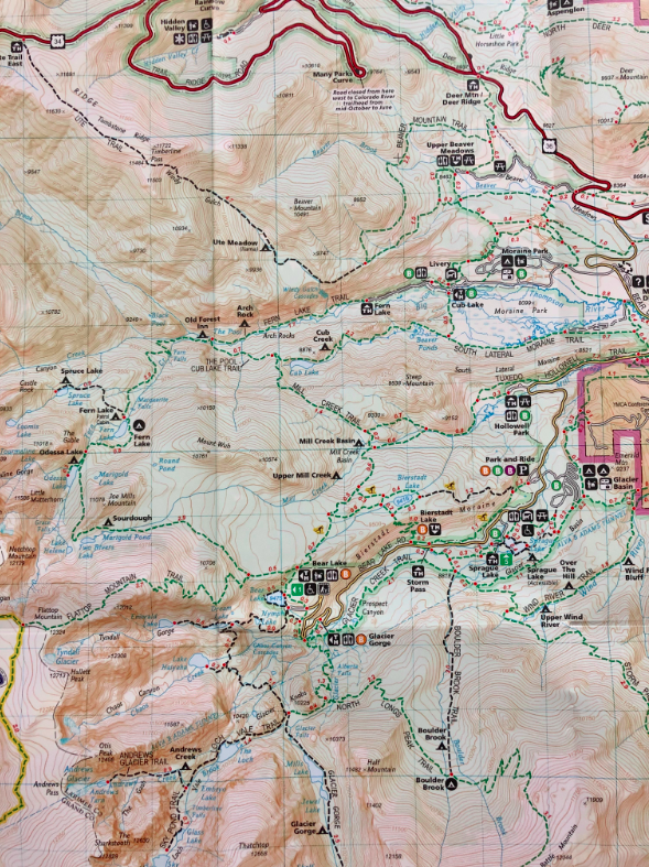
Loch Vale Trail Map- Colorado
Trails
There are two common starting locations for this hike, both are below (Bear Lake Trailhead has two route options):
Glacier Gorge Trailhead | 5.7 Miles| 1,040 Feet Elevation Gain
This is the most common path to head towards Mills Lake. If the parking lot is full, just continue on to Bear Lake Trailhead, park, and begin hiking from there.
Beginning at Glacier Gorge, hikers will travel .25 miles to the first junction of the Glacier Creek Trail, and the trail leading to Bear Lake. Hikers bear left, following the signs to Alberta Falls and Sky Pond.
.8 miles into the hike, hikers will reach Alberta Falls, a beautiful 30 foot waterfall that is extremely popular in summer months. The trails will have less people (but still quite a few) beyond this point.
1.6 miles into the hike, hikers will reach the North Longs Peak Trail Junction where hikers will need to bear right towards Sky Pond.
2 miles in, hikers will reach Mills Junction. To the left is Mills Lake and Black Lake, hikers will stay straight towards Loch Vale. Bearing right would bring hikers towards Sky Pond and Andrew’s Glacier. Hikers will arrive at the lake .8 miles after this junction.
Hikers can continue around the lake if they choose to.
Bear Lake Trailhead | 5.9 Miles | 1,050 Feet Elevation Gain
This route is only slightly different than starting at Glacier Gorge. The only difference is the first .4 miles. Here this trail descends to cross paths with where hikers will have started from Glacier Gorge. This portion of the trail is heavily trafficked year round. This route will add just a tiny bit of elevation gain, and .2 miles to your overall round trip. We recommend starting from Bear Lake if the Glacier Gorge trailhead has no parking.
Bear Lake Trailhead – Dream Lake, and Lake Haiyaha | 3.9 Miles One Way
Hikers can also choose to head towards Loch Vale from Bear Lake by bearing left at Dream Lake. This trail will take you past a spur trail towards Lake Haiyaha. This is a fantastic loop option. Starting from Bear Lake, heading to Lake Haiyaha, and then to Loch Vale is 3.9 miles one way.
Alternate Hikes
If hikers wish to extend the hike to the further lakes and nearby lakes, they should check out, Lake Haiyaha, Dream Lake, Emerald Lake, Sky Pond or Mills Lake as well.
Hiking Loch Vale in Winter
A frozen over Loch Vale is beautiful. Far fewer hikers are on this trail in winter, though it is still well traveled. Traction is highly recommended (microspikes or snowshoes). Most of the trail is fully manageable without traction, but as always, traction should be brought for caution. Snowshoes may be needed during certain times of year and is defendant upon snowfall.
Both trailheads are open and can be driven to in winter months due to Bear Lake Road being nicely maintained. Check park road closures during snowy times to be sure.
The route from Bear Lake to Dream Lake and Past Lake Haiyaha is far less traveled in winter than the other routes.
Fishing Loch Vale
If you like fly fishing for greenback cutthroat and brookies, this is a great catch and release fishery.
Directions & Parking
These are two large parking lots (bear lake trailhead the biggest), but these are extremely popular areas. Parking fills up extremely quickly on nice days. In many cases, hikers will need to use the National Park shuttle system to get to these trailheads during the busy months. Information on this can be found here: https://www.nps.gov/romo/planyourvisit/shuttle_bus_route.htm
To Glacier Gorge Trailhead
To Bear Lake Trailhead
Continue along bear lake road for .9 additional miles and you will reach the trailhead. This is the end of Bear Lake Road.
Current Weather Conditions
Here is a detailed weather forecast:
Allenspark, CO
Overnight
A chance of snow showers. Cloudy, with a low around 24. West wind around 24 mph, with gusts as high as 40 mph. Chance of precipitation is 50%. New snow accumulation of less than one inch possible.
Friday
Snow showers likely before noon, then snow showers and a slight chance of thunderstorms. Mostly cloudy, with a high near 37. West wind 12 to 26 mph, with gusts as high as 44 mph. Chance of precipitation is 90%. New snow accumulation of 1 to 3 inches possible.
Friday Night
Snow showers and a chance of thunderstorms. Cloudy, with a low around 25. East southeast wind 5 to 8 mph, with gusts as high as 20 mph. Chance of precipitation is 100%. New snow accumulation of 6 to 10 inches possible.
Saturday
Snow showers and a chance of thunderstorms. Cloudy, with a high near 27. East northeast wind 9 to 15 mph, with gusts as high as 24 mph. Chance of precipitation is 100%. New snow accumulation of 12 to 18 inches possible.
Saturday Night
Snow showers and a chance of thunderstorms. Cloudy, with a low around 21. North northwest wind 7 to 13 mph, with gusts as high as 21 mph. Chance of precipitation is 90%. New snow accumulation of 4 to 8 inches possible.
Sunday
Snow showers before noon, then snow showers and a slight chance of thunderstorms. Cloudy, with a high near 30. Chance of precipitation is 90%. New snow accumulation of 1 to 2 inches possible.
Sunday Night
A chance of snow showers and a chance of thunderstorms before midnight. Mostly cloudy, with a low around 22. Chance of precipitation is 50%. New snow accumulation of less than half an inch possible.
Additional Pictures
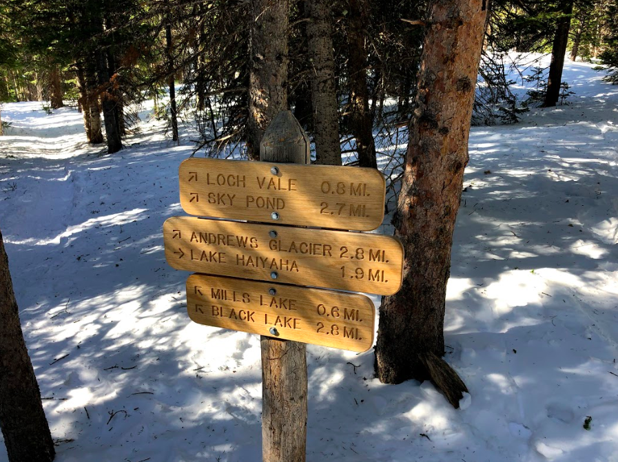
Trail Sign on Loch Vale Trail to Mills Lake

Mills Lake Views
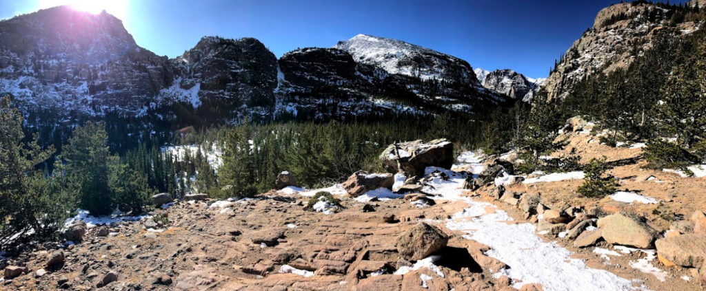
Trail Views to Loch Vale
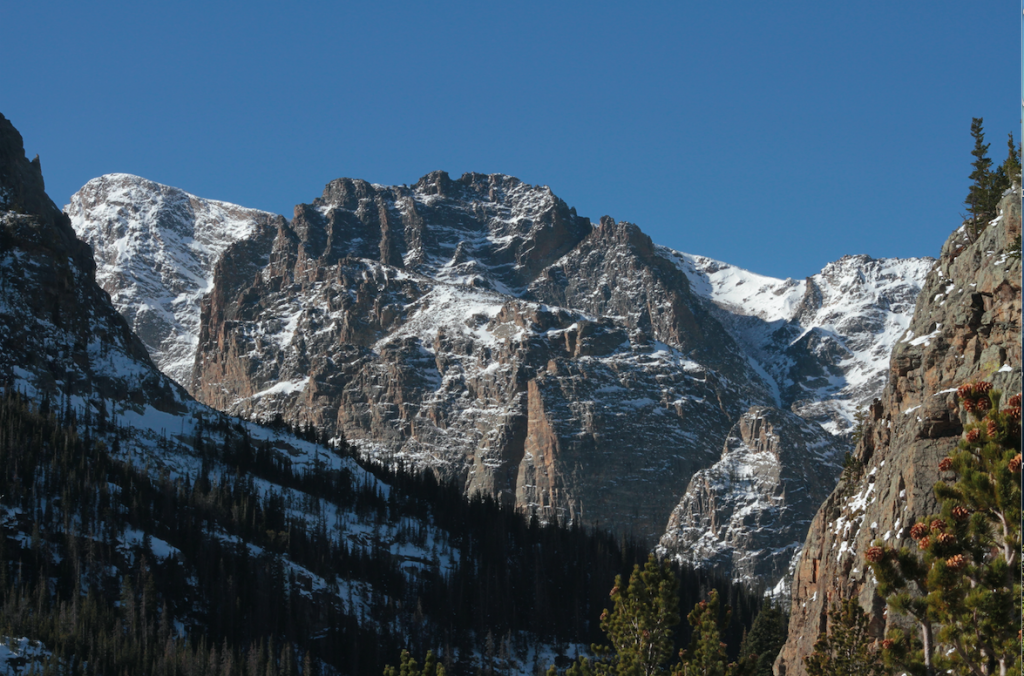
Trail Views Heading Towards The Loch
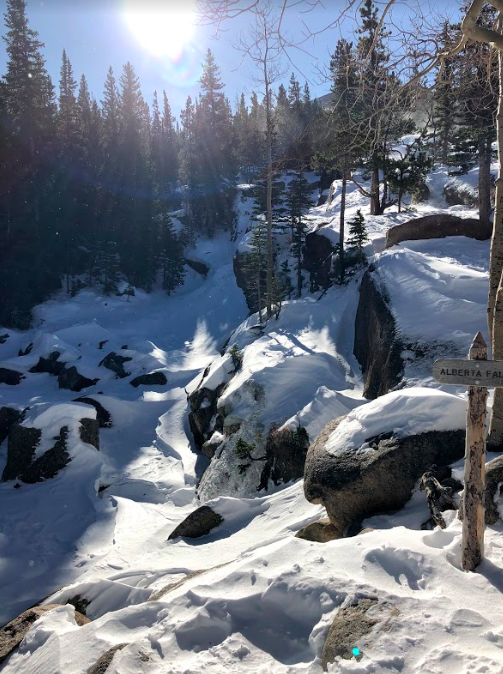
Alberta Falls (Winter)

Max DesMarais is the founder of hikingandfishing.com. He has a passion for the outdoors and making outdoor education and adventure more accessible. Max is a published author for various outdoor adventure, travel, and marketing websites. He is an experienced hiker, backpacker, fly fisherman, backcountry skier, trail runner, and spends his free time in the outdoors. These adventures allow him to test gear, learn new skills, and experience new places so that he can educate others. Max grew up hiking all around New Hampshire and New England. He became obsessed with the New Hampshire mountains, and the NH 48, where he guided hikes and trail runs in the White Mountains. Since moving out west, Max has continued climbed all of the Colorado 14ers, is always testing gear, learning skills, gaining experience, and building his endurance for outdoor sports. You can read more about his experience here: hikingandfishing/about