Hiking the Subway in Zion national park is an incredible experience. Only around 80 people are allowed to hike it per day, and you must obtain a permit before parking at the trailhead. If you have the chance to land a permit, be sure to take advantage.
Distance: 9 mile round trip (14.48 km)
Elevation Gain: about 1,400 feet (426 meters)
Hike Time: 5-8 hours
Difficulty: Strenuous
Quick Navigation:
Trails | Map | Directions | Permit | Weather
Need To Know Information:
- This hike is more difficult than the mileage and elevation gain state due to the not well maintained trail, river crossings, and just general difficult terrain. Plan for it to take longer than you would expect.
- This hike requires a permit. Read our permit section below for details.
- There are two different routes to make this trip The most common route is from the bottom up. The other option is from the top down. The top down requires rappelling gear. This article will cover the common route for average hikers.
- This hike is located about 30 minutes away from the Zion Visitors Center and not in Zion Canyon.
The Trails
Bottom Up Route (Most Common)
The trail to the subway isn’t really a trail, but a river, the Left Fork of North Creek. At the trailhead, you quickly descend down to the Left Fork, where you begin the 4.5 mile trek up along the sides of the Left Fork River to the subway. You will have to rock hop many times, cross the river, and you will see many beautiful pools of water (many of which contain rainbow trout)
Top Down Route (Requires Rappelling)
The less common, but many consider more exciting route to the Subway is from the top down beginning at the Wildcat Canyon Trailhead. This route is a 9.5 mile through hike, and requires 60 feet of rope, rock rappelling, and someone that can ensure you won’t get lost. You will also need to swim for various portions of the hike.
Both Trailheads are located on Kolob Terrace Road. (See directions below).
Trail Map
We made this trail map of the bottom up hike for you from the Left Fork Of North Creek Trailhead:
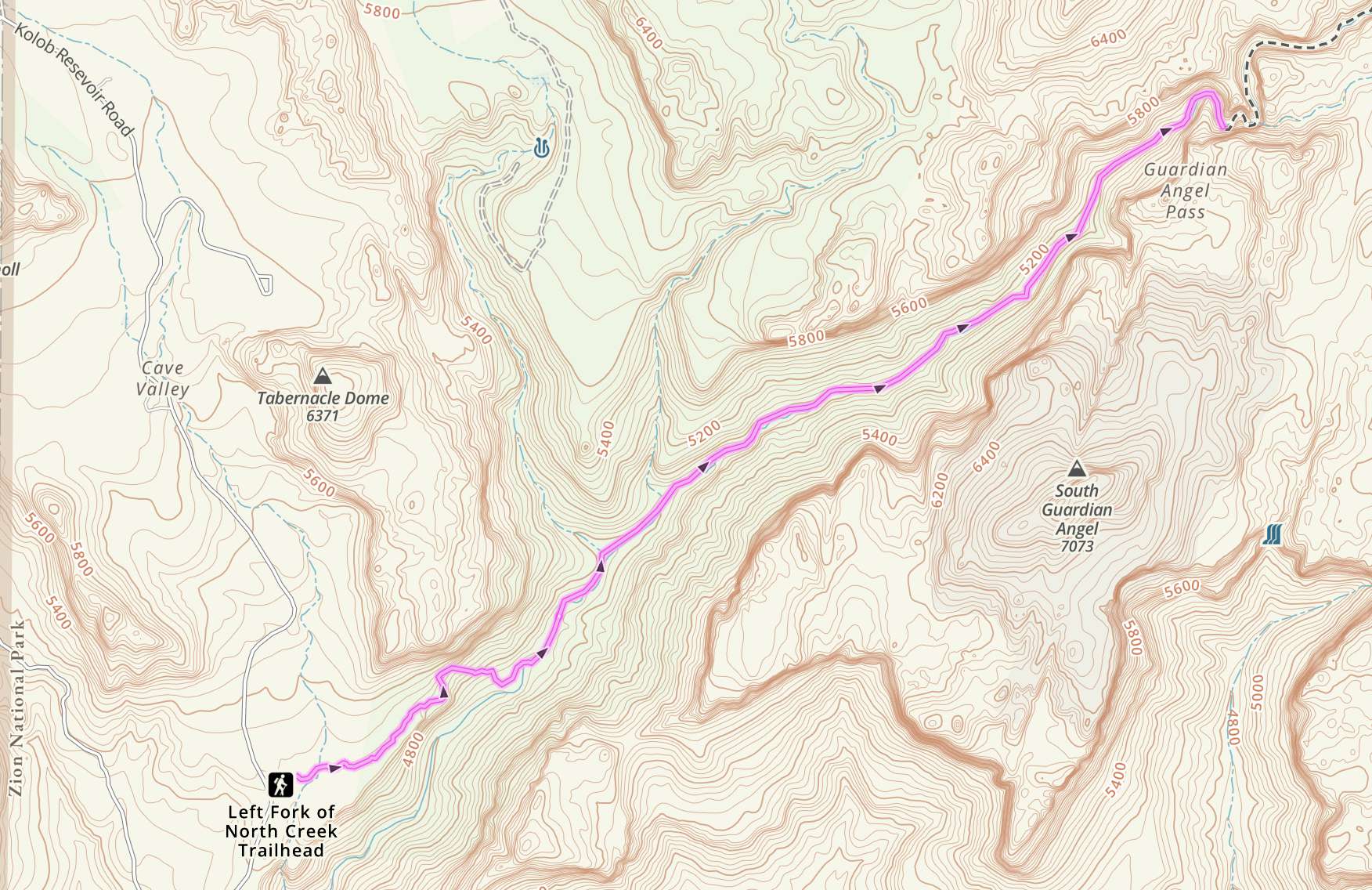
Zion Subway Trail Map

The Subway Hike: Bottom Up
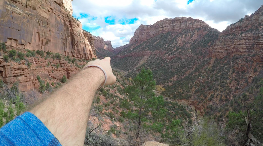
From the Left Fork Trailhead parking area, you will quickly begin descending down towards the river in which you will walk all the way up to the subway. (The picture below is taken just after the trailhead, pointing towards your destination, The Subway. You can see the river down below.
Important Note:
Shortly after leaving the trailhead, follow the well traveled trail that has cut and dug into the ground logs. Hikers will notice that a gully / dry stream runoff continues down and to the right. Many people accidently take the drainage to the right that has black rocks and many footprints from hikers that took wrong turns. Do not do so, and remain on the maintained trail.
The Subway
I don’t want to give away too many pictures, but this will hopefully these will give you enough reason to check this hike out.
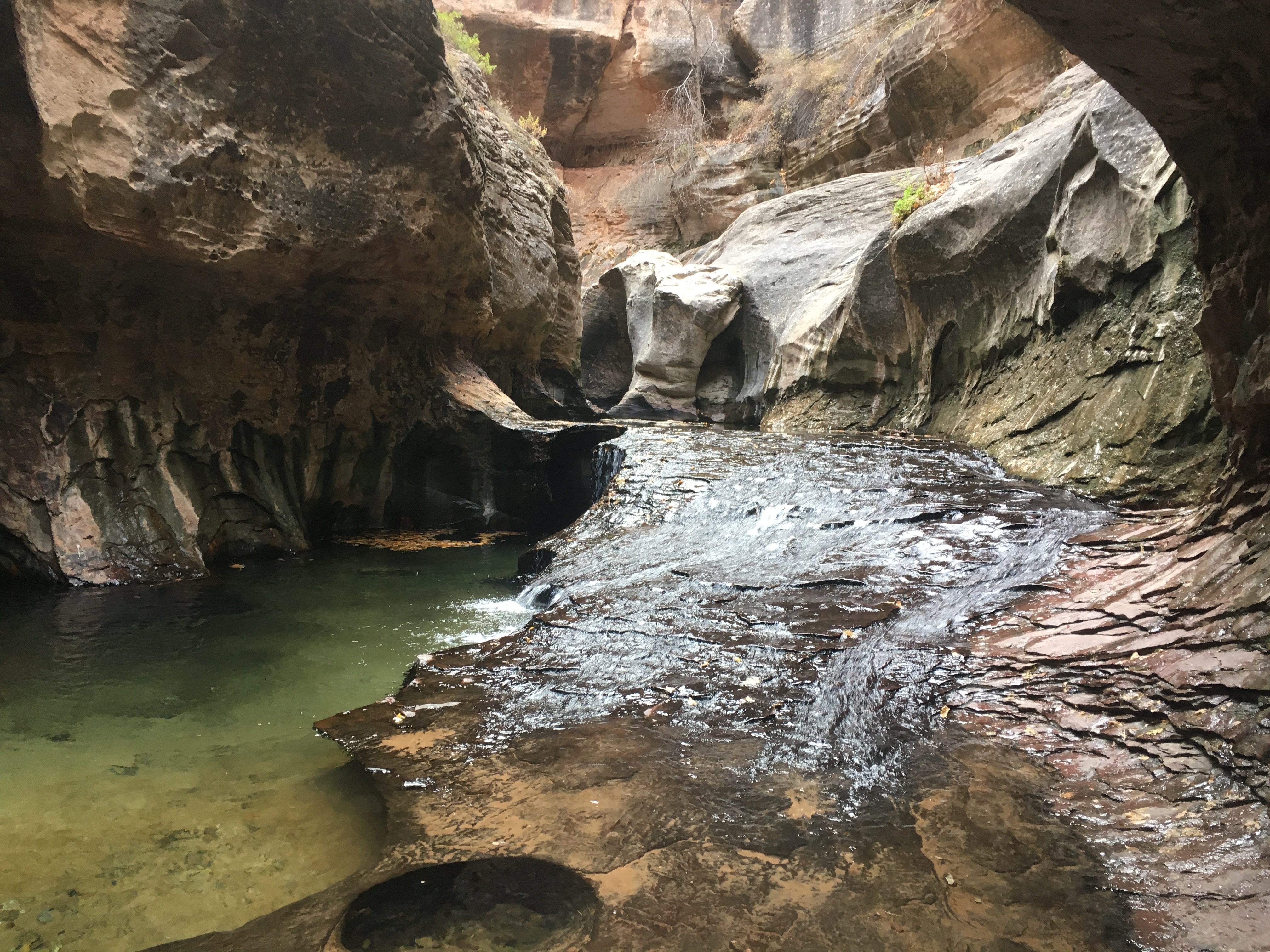
The Waterfall Room
Wanna go for a swim? In order to reach the waterfall room, you are going to have to hop into a couple pools of water, and swim to your reward. It’s worth it.
The Subway Hiking Permit
There are a couple of ways you can obtain a permit. You can apply online, 3 months in advance of your trip with a $5 lottery fee (non-refundable). You can also apply for a last minute drawing 2-7 days in advance of the hike, or you can get a walk-in permit the day of or the day before your hike. This last is a risky option, but during less frequented months, you can almost guarantee a spot this way.
Walk-In Permits can be obtained at the Zion National Park Visitor Center
Want to apply online? See here: https://www.nps.gov/zion/planyourvisit/subwaypermits.htm
Permit Costs:
$15 for 1-2 people
$20 for 3-7 people
$25 for 8-12 people
What to Wear Hiking the Subway?
You should be prepared to get your feet wet at the end of the hike, and potentially early on during high water times. Like the narrows, you may be hiking with wet feet all day. Simply be prepared for this and staying warm for whatever the temperature conditions are going to be.
Directions to Trailheads on Kolob Terrace Road.
Left Fork Trailhead (Bottom Up)
Wildcat Canyon Trailhead (Top Down)
Other Zion National Park Hikes
If you are a little nervous about hiking the Angel’s Landing trail, or maybe need a few extra hikes in Zion, you should absolutely check out the following:
We also have a guide to the Best Hikes In Zion that you should check out.
Weather Forecast
Springdale, UT
Today
A chance of rain showers before noon, then showers and thunderstorms. Cloudy. High near 53, with temperatures falling to around 48 in the afternoon. Southwest wind 8 to 14 mph. Chance of precipitation is 90%.
Tonight
Showers and thunderstorms. Cloudy. Low around 34, with temperatures rising to around 36 overnight. Southwest wind 6 to 9 mph. Chance of precipitation is 80%.
Saturday
A chance of rain showers. Partly sunny, with a high near 56. West northwest wind 7 to 15 mph. Chance of precipitation is 40%.
Saturday Night
Mostly clear, with a low around 33. North wind 7 to 15 mph.
Sunday
Sunny, with a high near 64. North northwest wind 6 to 10 mph.
Sunday Night
Mostly clear, with a low around 37.
Monday
Sunny, with a high near 69.

Max DesMarais is the founder of hikingandfishing.com. He has a passion for the outdoors and making outdoor education and adventure more accessible. Max is a published author for various outdoor adventure, travel, and marketing websites. He is an experienced hiker, backpacker, fly fisherman, backcountry skier, trail runner, and spends his free time in the outdoors. These adventures allow him to test gear, learn new skills, and experience new places so that he can educate others. Max grew up hiking all around New Hampshire and New England. He became obsessed with the New Hampshire mountains, and the NH 48, where he guided hikes and trail runs in the White Mountains. Since moving out west, Max has continued climbed all of the Colorado 14ers, is always testing gear, learning skills, gaining experience, and building his endurance for outdoor sports. You can read more about his experience here: hikingandfishing/about
Lots Of Snow & Fishing Amazing
The snow made for lots of postholing and very difficult traveling. Lots of downed trees that i’m sure will be fixed come the busy season.
Caught and released 10+ fish. Amazing fishing.
Incredible Weather, Trail Solid
While the trail isn’t the greatest trail, everything was in good condition. Easy to cross rivers. Tons of fish visible, next time I am bringing my fly rod. Great day overall!