The Pemigewasset Loop (pemi loop) is a 31 mile loop hike in New Hampshire’s White Mountains. The Pemigewasset Wilderness is surrounded by various hiking trails that make up the entire loop. Hikers will end up climbing at least 8 of NH’s 4000 footers, and gaining over 9,000 feet in elevation during the trip. The loop is most frequently hiked in 2 or 3 days, but some athletes tackle all the mountains in a single day hike.
There are additional routes that can add mileage, elevation gain and even other 4,000 foot peaks. (We will delve into these options later)
Distance: 31 Miles (49.89 km)
Elevation Gain: 9,000 feet (2,743.2 meters)
Difficulty: Extremely Strenuous
Book Time: 20 Hours 17 Minutes
Links To Info On This page:
Routes | Camping | Water | Pemi Loop Map | Food | Gear | Directions | 4000 Footers On The Loop
Route Information
The Pemi Loop can be done in many ways, from various starting points, traveling in a clockwise, or counter clockwise direction. This post is going to highlight the most common, but also help you choose the best path for your needs.
Pemi Loop Map
We have built several different maps so that you can work with the technology and tools that work best for you.
GPX and Online Map: The first map we created is on GAIA where you can download the GPX file and upload it to any tool that you use. You can find that Pemi Loop Map here.
Pemi Loop PDF Map With Water Stops:
Take a look at our edited map with mileage, water stops, and camping locations: Pemi Loop Map
In addition to having the route saved to your phone or handheld GPS, we highly recommend that you bring quality trail maps for a trip like this one on Amazon.
Lincoln Woods Trailhead
From the Lincoln Woods Trailhead (directions below) hikers can choose to do the Pemigewasset loop in a clockwise or counter clockwise direction. There is ample parking, bathrooms, water fill ups, RV sites, campsites, and hotels very close to the trailhead. Hikers begin by crossing a gorgeous footbridge over the East Branch of the Pemigewasset River, and hiking along a flat section of an old logging railroad with beautiful views along the river.
If hikers take this route in a clockwise direction, they will be ascending to Mount Flume from the Osseo trail, one of the easiest 4,000 foot ascents in the Whites. Continuing along Franconia Ridge, hikers will then summit the beautiful Mount Liberty, continue along to Little Haystack, Lincoln, and then the highest point on the Pemi Loop, Mount Lafayette. This ridge hike is stunning and features views of all of the summits of the Pemi Loop, views into Franconia Notch, and even views of Mount Washington.
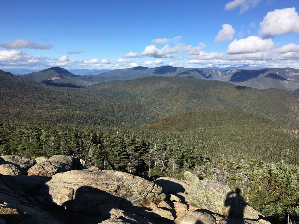
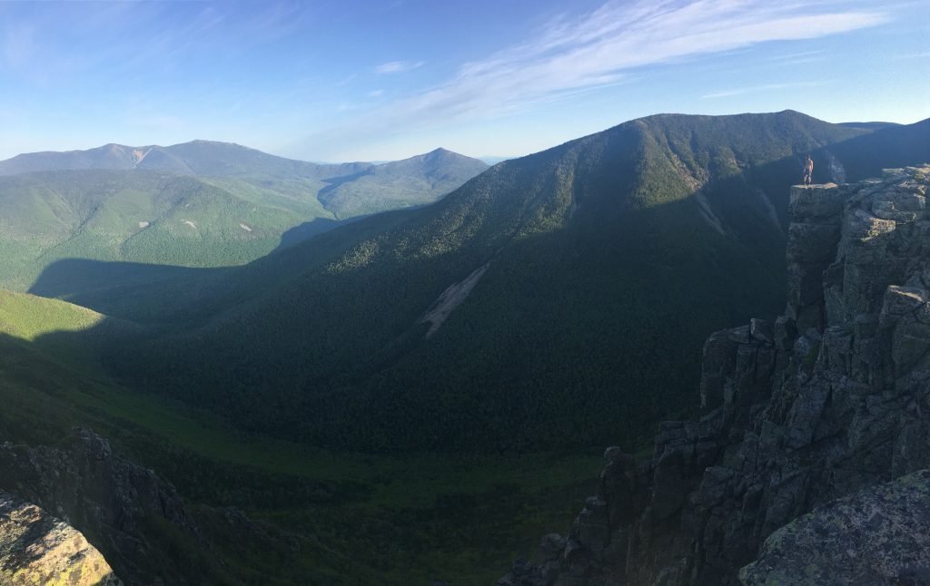
Views of Pemi Wilderness from Mount Flume
Hikers will descend down to Mount Garfield where there is a campsite location and water available for filtering. Continuing along the Garfield Ridge, hikers will descend, then rise to South Twin Mountain. It is here where hikers have the option to make the brutal descent down to the Galehead Hut. Brutal, because they will have to ascend back up to South Twin (.8 miles of around 1,000 feet of elevation gain).
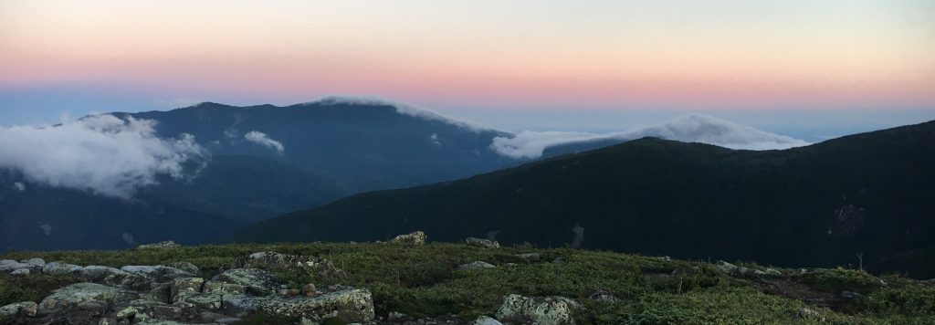
Sunrise from Mount Guyot
Hikers will then head south towards Mount Guyot (not a 4,000 footer, but a beautiful summit), and then on to Mount Bond. Before reaching the summit of Bond, a spur trail leads .5 miles to the summit of West Bond. This gorgeous summit is worth the 1 mile round trip detour. Summiting Mount Bond may be your highlight of the loop. The views are breathtaking in all directions, especially towards Bondcliff.
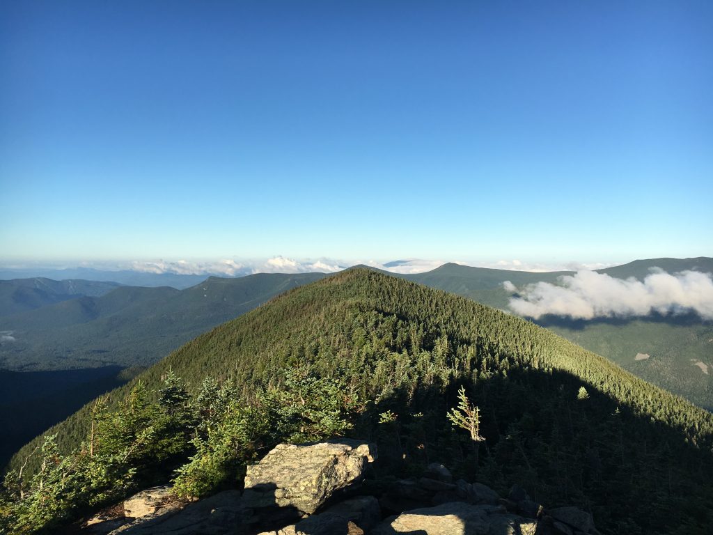
Views from West Bond
The descent down to Bondcliff features incredible views. Bondcliff will be your final summit in the loop. Sitting 9 miles from your starting point. The way down features around 4 and a half miles of descent before flattening out and paralleling the West Branch of the Pemi for another 4 and a half miles.
Views from Bondcliff
Other Trailheads
Entering the loop can be accomplished from just about any trailhead surrounding the Pemi Wilderness. One of the most common alternate entrance points to the loop is from Franconia Notch, where hikers often park at the Lafayette Campground parking area. This parking is free, and gives hikers the option to summit the largest peak of the loop first.
Choosing the best starting location is really up to the hiker’s preference. Routes differ in a few different ways:
Parking: Parking is free in some areas, and $5 per day in other areas. Some locations are of course farther north or south than others, making driving distances differ. This may be a consideration for some.
Elevation Gain: Lincoln Woods allows you to rise to the loop in either direction, and maintain high elevation during the entire loop. Other options will make it necessary for hikers to ascend to the loop, descend down to Lincoln Woods, before needing to ascend back up to the loop. This is very much the case with starting in Franconia Notch, where mileage and elevation gain is added.
Difficulty: Certain starting points feature steep sections while others are more gradual gains. As an example, Lincoln Woods Trailhead or the Garfield Trailhead offer gradual gains, while you’ll experience steeper ascents starting from The Falling Waters Trail or the Old Bridal Path of Franconia Notch.
- Lincoln Woods
- Liberty Springs
- Falling Waters
- Old Bridal Path
- Garfield Trail
- North Twin
Camping Information
Possible camping locations are marked in red on the attached map. The most convenient camp sites would be the Garfield Ridge campsite and the Guyot campsite. These may fill up, but there are some back country sites to camp along the loop. These options are described in more detail below. Please refer to the camping rules before choosing a back country location (link below).
Campsite: Garfield Ridge Campsite: $10 per person. Info on site here: https://www.outdoors.org/lodging-camping/campsites/campsites-profile
Campsite: Guyot Campsite: $10 per person. Info on site here: https://www.outdoors.org/lodging-camping/campsites/campsites-profile
Campsite: Liberty Springs Campsite: $10 per person. Info on site here: https://www.outdoors.org/lodging-camping/campsites/campsites-profile
BIG NOTE: These campsites are first come first serve… you are going at a busy season, it is possible that they will be full. They may have overflow campsites that they will point you to, but if not, you’ll have to find a legal place to set up a back-country campsite.
There are numerous places where you can do this, especially on the ridge between South Twin and Guyot. If you must camp in the back country, you should follow the rules below:
Camping Rules: https://www.fs.usda.gov/Internet/FSE_DOCUMENTS/stelprdb5363715.pdf
AMC Huts:
The Pemi Loop offers 2 AMC huts that can be stayed in: The Greenleaf Hut off of Mount Lafayette, and the Galehead Hut off of Mount Galehead. These are great options to stay at for completing the loop. You can get beds, a meal, some desert, and plenty of hydration.
Stealth/backcountry camping spots:
Garfield Pond – (Various sites.) In 1936 this was the shelter location for AT hikers. The current shelter is over Garfield at Garfield Ridge Campsite, another 2 miles N on the AT. (marked on map) (There is also a single tent space near the summit of Garfield)
Galehead Summit: At the summit of Galehead, there are a couple of hard packed areas which you could set up some tents. (marked on map as Galehead summit)
Between South Twin and Mount Guyot – Get water at Galehead Hut – various sites. Closer to Guyot than S. Twin. (Marked on map)
North of the summit of Mount Bond also has packed areas where people have tented. Most of these are illegal sites. There are also some on the spur of West Bond.
There is also plenty of flat areas at the base of Bondcliff near Lincoln Woods. I do highly recommend sleeping up high if the weather is nice, as waking up on the ridge of the bonds is an incredible experience. The base of bondcliff requires getting off trail by 200 feet to be compliant with rules.
This is by no means a full list, there are certainly other legal and non-legal camping spots that you can find along the way if your plans change a bit.
Hammock Camping
A hammock is a great option for this longer loop. There are plenty of places along the loop where Hammock setups are fantastic. This will also save weight, and can be more comfortable. Check out our complete guide to hammock camping.
Water & Hydration
It is essential that you pack enough food and water for this trip. There are various clean water fill stations at AMC huts along the way, but it is extremely important to pack proper food and hydration as this is a strenuous multi-day hike.
It is recommended to also bring some type of water filtration device in case you run low on water and need to collect from a stream or spring. You can also choose to carry less than the recommended amount of water if you are willing to stop and filter water frequently.
Amount of Water: 1 liter for every two hours of hiking (this is a lot of water, but if you want to insure you stay hydrated, then this is what must be done). Your longest stretch without access to water is 14.1 miles (about 8 hours of hiking. This means 4 liters should suffice if you don’t bring water filtration. It is highly recommend to bring water filtration devices or tablets to utilize at the springs and campsites labeled on the map. If you don’t bring filtration, clean water is available at Greenleaf Hut (2 miles round trip out of way), and Galehead Hut. Realistically you can probably get away with less water, 2-3 liters, if you conserve, filter water and refill at filling stations.
Food & Calories
- Nuts / Trail Mix / Granola
- Canned Beans
- Dehydrated hike meals
- Sandwiches – with lean meats and veggies
- Dehydrated Fruit
- Avocados are easy to store and pack lots of calories
- Granola bars
Calories: A LOT (you should bring at least 6,500 calories)
Gear & Supplies
- Footwear that you are used to, and durable. Hiking boots are great for wet sections, but trail runners can be great lightweight options as well.
- Layers – Even though it is summer, it can get cold, and having layers is crucial to keeping the right core temperature
- Rainjacket – This is an absolute must.
- Headlamp and flashlights (extra batteries too)
- Detailed Trail Maps
- Extra socks, underwear, shirt and lower layer.
- Sleeping bag (rated for proper season), sleeping pad, tent, and tent footprint. (or hammock)
- Knife
- Compass
- Emergency blanket and knife
- Sunscreen and sunglasses
- First Aid Kit
- Fire starting kit
- Eating Utensils
- Water filtration/treatment system
- Toilet Paper
- Trash bag
- Waterproof cover for backpack/waterproof bag for inside backpack
Looking to do the loop in Winter? Check out our Winter Hiking Guide, and Winter Hiking Clothing Guide.
Trail Maps:
You have to bring quality trail maps for a trip like this. Here is one on Amazon
Weight
This is dependent. Obviously, the lighter the better. If you aren’t used to heavy elevation gain (or anyone in your party) this hike will be difficult. Rising to Lafayette, or to the bonds, is a lot of elevation gain, and weight certainly makes a big difference. Don’t exceed 30 pounds. I would aim for 20 to 25 for overnight hikers. Day hikers should of course be packing as light as possible.
Human Waste
Practice Leave No Trace (LNT), carry in, carry out, meaning if you gotta go, please have a human waste bag, and pack it in your bag with you. There are places to go on the trail. The AMC huts have bathrooms, and some campsites do have designated go areas. Worst case scenario, you dig a hole and bury your waste.
Link to some baggies on Amazon (there are quite a few options):
Parking Information & Directions
Parking for suggested route is located at Lincoln Woods Trailhead: Here are directions: https://goo.gl/maps/yMXaqT3uAs72
If your hike is going to start in Franconia Notch State Park, you will not have any parking fees.
Parking Fee: There is a self serve pay station where you collect an envelope and a tag for your dashboard/rearview mirror. The fee is $5 per day per car. This fee is not at every trailhead, but most within White Mountain National Forest.
Getting to the trailhead you would like to start from should be simple. In most cases Google Maps can navigate you directly to your trailhead by simply typing in the trailhead you are looking for. In some cases, you may have to zoom in on your map, and have a GPS navigate to a manually selected point, or pull out a good old paper map.
How Many 4,000 Footers Are On The Pemi Loop?
The 4,000 foot mountains summited with the Pemi Loop:
- Bondcliff
- Bond
- West Bond (optional and can be added with 1 mile detour)
- South Twin
- Garfield
- Lafayette
- Lincoln
- Liberty
- Flume
When looking at a map, you will notice quite a few other 4,000 foot mountains that could be summited with detours:
- North Twin
- Galehead (Adds 1.6 miles and about 1,200 feet of elevation gain)
- Zealand
- Owl’s Head (Way Way out of the way in the middle of the Pemi Wilderness)
Current Weather Conditions
Lincoln, NH
This Afternoon
Showers and thunderstorms likely. Mostly cloudy, with a high near 63. West wind around 5 mph. Chance of precipitation is 70%. New rainfall amounts between a tenth and quarter of an inch possible.
Tonight
Showers and thunderstorms likely before 2am. Mostly cloudy, with a low around 44. West wind 5 to 10 mph. Chance of precipitation is 70%. New rainfall amounts between a quarter and half of an inch possible.
Monday
Partly sunny, with a high near 61. Northwest wind around 10 mph.
Monday Night
A slight chance of rain showers after 3am. Partly cloudy, with a low around 39. Northeast wind 5 to 10 mph.
Tuesday
A chance of rain showers. Mostly cloudy, with a high near 56. Southwest wind 0 to 5 mph. Chance of precipitation is 50%.
Tuesday Night
Rain showers likely. Mostly cloudy, with a low around 42. Chance of precipitation is 70%.
Wednesday
A chance of rain showers. Mostly cloudy, with a high near 55. Chance of precipitation is 40%.

Max DesMarais is the founder of hikingandfishing.com. He has a passion for the outdoors and making outdoor education and adventure more accessible. Max is a published author for various outdoor adventure, travel, and marketing websites. He is an experienced hiker, backpacker, fly fisherman, backcountry skier, trail runner, and spends his free time in the outdoors. These adventures allow him to test gear, learn new skills, and experience new places so that he can educate others. Max grew up hiking all around New Hampshire and New England. He became obsessed with the New Hampshire mountains, and the NH 48, where he guided hikes and trail runs in the White Mountains. Since moving out west, Max has continued climbed all of the Colorado 14ers, is always testing gear, learning skills, gaining experience, and building his endurance for outdoor sports. You can read more about his experience here: hikingandfishing/about